|
NORTH YORKSHIRE - Cloughton Woods and Hayburn Wyke
'Woods & Wykes'
This is a more adventurous variation on the other Dales Trails walk linking Cloughton and Hayburn Wyke - see Cloughton
By going off the beaten track through Cloughton Woods, you follow an alternative route to Hayburn Wyke. The cliff top Cleveland Way again provides the return route enabling you to sample the delights of Hayburn Wyke and Cloughton Wyke on the North Yorkshire coast, with views towards Scarborough before cutting back inland along Salt Pans Lane to Cloughton.
Fact File
|
Distance
|
13km (8ỳ miles)
|
|
Time
|
4 hours
|
|
Map
|
OS Explorer OL27 North York Moors East
|
|
Start/Parking
|
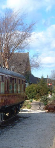
Cloughton old railway station - former goods yard, grid ref: TA 012 940.
|
|
Terrain
|
Can be rough and muddy through the woods plus there are streams to be crossed. There are a number of steep ups & downs along the coastal path. Note: the cliff-top path is liable to erosion take notice of any local diversions that may be advised.
|
|
Grading
|
*** moderate but extra care needed descending to Hayburn Beck
|
|
nearest Town
|
Scarborough
|
|
Refreshments
|
Pubs in Cloughton and at Hayburn Wyke. Tea-room at Cloughton Old Station.
|
|
Toilets |
Cloughton Old Station tearoom (for customers)
|
|
Public Transport
|
Cloughton is served by buses 15 (Scarborough & District - Ẅ hourly - not Sundays) and 93/93A (Arriva North East - hourly - daily).
|
|
Suitable for
|
enthusiastic walkers - The cliff-top path is unsuitable for young children, and dogs should be kept under control. Cattle and sheep in the vicinity of The Hulleys
|
|
Stiles
|
8
|
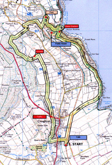
Route created using TrackLogs Digital MappingImage reproduced with kind permission of Ordnance Survey and Ordnance Survey of Northern Ireland.

- (Start) From the parking area, behind the old railway goods shed, walk back past the front of the station buildings, now a tea-room, turn left and walk back down to the main road. Cross straight over to follow a walled track down to the beck and the village football pitch. Turn right and walk along the side of the pitch to a lane turn right across the beck then immediately left through a gate. Walk by the stream towards the village cricket pitch. Do not take the path up to the right, but continue along the edge of the cricket pitch to find a narrow flagged path between gardens. This brings you out onto the main road at the edge of the village.
- (1.5km/1mile) With care, cross over to a gate (FP sign) leading to a rough walled track that climbs steadily up through woodland. At the top you enter pasture and maintain direction towards and through a thicket of gorse. The path dips through a wooded area after which it follows a rutted track up alongside a wall towards The Hulleys farm. At the gateway turn left (FP sign) down to the farm. Tractors and cattle can cause this area to be quite muddy! Pass between the farm buildings to a stile by a gate, then bear right down a slanting path, swinging left alongside a stream at the bottom. Cross the stream to reach a way-marked gate into Cloughton Wood.
- (3.5km/ 2ỳmiles) Head up into the woods, turning right at way-marked post along a narrow path through brambles and bracken. Maintain a northerly direction through the woods, roughly parallel with the main road, which can be heard but not seen. It can be difficult to follow the path, as you must deviate to avoid logs and fallen trees. Eventually you encounter a dyke and track crossing at right angles go right to follow this track down through the trees and across a stream. It climbs up along the edge of the wood to a gate onto the Staintondale road. There are views north towards the mast at Ravenscar.
- (6.4km/ 4miles) Turn left down the road to a gate on the right (FP sign). Go into the field and follow the track past a barn and smallholding towards a bridge over the old railway line. Go through the gate at the far end of the bridge and continue forward to walk along the edge of a field, parallel to the old line. Two stiles take you in and out of a small triangular copse and into another field. In the distance is the Hayburn Wyke hotel. However our route goes left down the field to a gate in the corner. Here you enter woodland, with Hayburn Beck down below. The path picks its way steeply down through the trees towards a confluence of streams. It is easier to cross each in turn before their confluence, but take care the rocks are slippery. Safely over, you join a clear path to follow the beck downstream. In places cut logs form the path surface and again can be slippery.
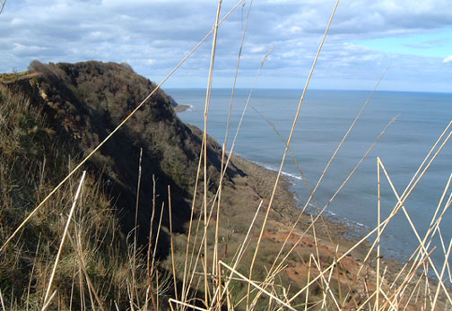
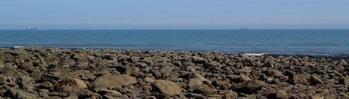
- (8km/ 5miles) This wooded valley is delightful setting with the stream tumbling over mossy rocks on its way down to a waterfall onto the beach. It is quite peaceful also, as most visitors approach Hayburn Wyke direct from the Hotel. Go right to cross a footbridge and continue down stream with the beck now on your left. The path climbs up above the beck and joins the main tourist route from the hotel, before descending once more. You arrive at a rock outcrop, with the rocky shore and the North Sea ahead of you. Whilst the beck cascades over the outcrop, you must scramble down to the right. This sheltered cove makes a superb spot for a picnic. However take care not to twist an ankle on the boulders.
- (8.5km/ 5ẅmiles) Scramble up from the shore and walk back a short distance, turning left to follow the Cleveland Way (acorn symbol) steeply upwards. At a fork bear left to continue on the Cleveland Way (the other path continues to the Hotel). At last the top is reached at a gate where you turn left to follow the edge of a field. At first views are restricted by trees and bushes but as you climb higher openings appear and you have an amazing birds-eye of the waterfall and cove its hard to believe thats where you were a few minutes ago. The route for the next couple of miles requires no description you continue south on the Cleveland Way, which hugs the cliff-top all the way to Scarborough. The going is not always easy though, as there are several steep ups and downs (assisted by steps) where streams have cut through to the shore.
- (10km/ 7ỳmiles) One of these occurs at Salt Pans and the path loops inland to reduce the gradient. The lane from here provides a direct route back to Cloughton. Following this lane inland, you have a view ahead to the wooded Silpho Brow the eastern fringe of the higher ground of the North York Moors. Just before the village the lane passes over the old railway on a bridge. Here descend the steps to join the track for the final km back to Cloughton Station. There, what better way to end your walk than with afternoon tea on the lawn between the platforms of the old station (13km, 8ỳ miles)
Along the Way
The coastline north of Scarborough is broken by numerous 'wykes' - old Yorkshire for a small inlet - too small to be called a 'bay'. Of these, Hayburn Wyke is probably the most attractive, with the beck tumbling over a waterfall onto the rocky shore.
None of the 'wykes' are particularly accessible, but with the coming of the railway in 1885 a station and hotel were built above Hayburn Wyke to attract visitors to the area. The railway was dismantled in the 1960's and today, reopened as a permissive path, it provides easy going for part of this walk.
The hotel remains and, from its car-park, footpaths descend steeply into the wooded valley to the waterfall. The whole area is a Nature Reserve in the care of the National Trust and the Yorkshire Naturalist's Trust.
Arnold Underwood & Caroline Gowthorpe (April 2004)
|