|
NORTH YORKSHIRE - Cloughton to Hayburn Wyke
'Ways to the Wykes'
Sections of the disused coastal railway and the Cleveland Way provide the route enabling you to sample the delights of Hayburn Wyke and Cloughton Wyke on the North Yorkshire coast.
Fact File
|
Distance
|
14km (9 miles) but can be shortened
|
|
Time
|
allow up to 5 hours
|
|
Map
|
OS Explorer OL 27 North York Moors Eastern Area
|
|
Start/Parking
|
Cloughton old railway station - former goods yard, grid ref: TA 012 940.
|
|
Terrain
|
Easy going on the old railway, but a number of steep ups & downs on the coastal path. Note: Cliff-top path liable to erosion - take notice of any local diversions that may be advised.
|
|
nearest Town
|
Scarborough
|
|
Refreshments
|
Pubs in Cloughton and at Hayburn Wyke. Tea-room at Cloughton Old Station.
|
|
Toilets |
none
|
|
Public Transport
|
Cloughton is served by buses 15 (Scarborough & District - ˝ hourly - not Sundays) and 93/93A (Arriva North East - hourly - daily).
|
|
Suitable for
|
all, however, the cliff-top path is unsuitable for young children and dogs should be kept under control.
|
|
Stiles
|
a few on the cliff-top path.
|
- (Start) From the parking area, behind the old railway goods shed, walk back past the front of the station buildings, now a tea-room, turn right and join the old track-bed. This cinder-surfaced track now forms a continuous concessionary right-of-way from Scarborough to Whitby. Head north along the track, soon passing under a bridge carrying Salt Pans Lane (a possible short cut on your return) and then over the access lane to Sycarham farm. Trees and bushes have sprung up since the line was closed in the 1960's so you often appear to be walking through a tunnel of foliage.
- (3km/2Ľmiles) You cross the Hayburn Wyke Hotel access road on the level, but it is too early in the walk to make the short diversion there. There was a station here, built solely for visitors to the Hotel and the beauty spot of Hayburn Wyke. Your route however will be a little longer, and will approach the Wyke by way of hidden valley. So press on along the old railway. The surroundings become more wooded and the track curves further inland coming quite close to the Staintondale road before curving back towards the sea. You come to an over-bridge and here leave the track for the minor road.
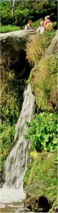
- (5km, 3Ľmiles) Walk down the lane, past Lowfield caravan site and up towards a farm. Where the lane turns into the farm, continue ahead along a field path with woodland on your right. At a gate, signed 'path to beach & cliff', enter the woods and take a clear path which gradually descends the wooded sides of this secret valley to come alongside Hayburn Beck. This is delightful setting with the stream tumbling over mossy rocks on its way down to a waterfall onto the beach. It is quite peaceful also, as most visitors approach Hayburn Wyke direct from the Hotel. Cross a footbridge and continue down stream with the beck now on your left. You arrive at a rock outcrop, with the rocky shore and the North Sea ahead of you. Whilst the beck cascades over the outcrop, you must scramble down to the right. The sheltered cove, providing the wind is not a north-easterly, makes a superb spot for a picnic. However take care not to twist an ankle on the boulders.
- (6.2km, 4miles) Scramble up from the shore and walk back upstream a short distance, turning left to follow the Cleveland Way steeply upwards. At a fork bear left to continue on the Cleveland Way (the other path continues to the Hotel). At last the top is reached at a gate where you turn left to follow the edge of a field. At first views are restricted by trees and bushes but as you climb higher openings appear and you have an amazing birds-eye of the waterfall and cove - it's hard to believe that's where you were a few minutes ago. The route for the next couple of miles requires no description - you continue south on the Cleveland Way, which hugs the cliff top all the way to Scarborough. The going is not always easy though. There are several steep ups and down (assisted by steps) where streams have cut their way through to the shore.
- (8.5km, 5Ľmiles) The first of these occurs at Salt Pans and the path loops inland to reduce the gradient. A lane from here provides a short-cut back to Cloughton. The path then loops again down and round the narrow cove of Cloughton Wyke. Looking back from the southern edge of the cove reveals some amazing rock strata in the cliffs. Soon the path dips again to cross the shortest dale in Yorkshire, Hundale - just 200yds long. Hugging the cliff top once more your next objective is the coastguard look-out station on Long Nab. Ahead stretches Scarborough bay, with the Castle prominent on its cliff-top. ˝km on from Long Nab, the path makes yet another tight turn to negotiate a gully. This is Crook Ness, and at this point you leave the coastal path.
- (12km,7ľ miles) Follow a lane inland, round a sharp bend, towards Burniston. After topping a slight rise you have a clear view over Burniston of the wooded Silpho Brow - the eastern fringe of the higher ground of the North York Moors. Just before the village the old railway passes over the lane on a bridge. Climb the steps to rejoin the track for the final km back to Cloughton Station. There, what better way to end your walk than with tea and scones on the lawn between the platforms of the old station
Along the Way
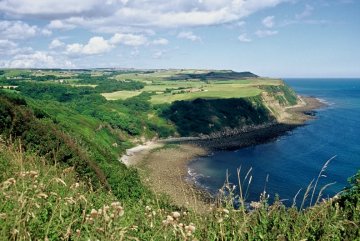
The coastline north of Scarborough is broken by numerous 'wykes' - old Yorkshire for a small inlet - too small to be called a 'bay'. Of these, Hayburn Wyke is probably the most attractive, with the beck tumbling over a waterfall onto the rocky shore.
None of the 'wykes' are particularly accessible, but with the coming of the railway in 1885 a station and hotel were built above Hayburn Wyke to attract visitors to the area. The railway was dismantled in the 1960's and today, reopened as a permissive path, it provides easy going for part of this walk.
The hotel remains and, from its car-park, footpaths descend steeply into the wooded valley to the waterfall. The whole area is a Nature Reserve in the care of the National Trust and the Yorkshire Naturalist's Trust.
The magnificent cliffs around Cloughton Wyke are of interest to geologists, looking for fossils in the rock strata, and to seabirds, looking for nest sites.
Arnold Underwood (Sept 2002)
|