|
North York Moors - Yedmandale from East Ayton, 14km (9miles)
'Yedmandale & Forge Valley'
This walk follows a narrow lane from East & West Ayton up secluded Yedmandale into Wykeham Forest.
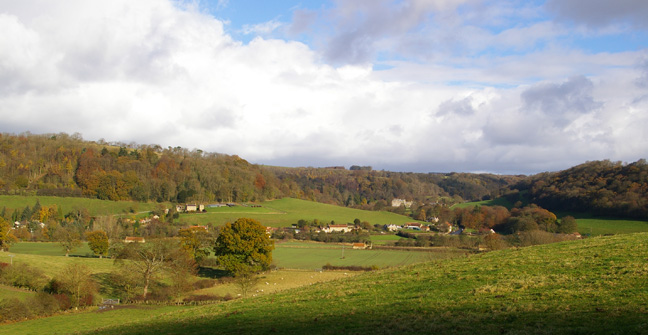
With views over Hackness, the return leg descends to follow the River Derwent through Forge Valley to the ruins of Ayton Castle
Fact File
|
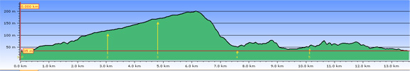
Distance
|
14km (9miles)
|
|
Terrain
|
A mix of field and forest paths, and minor roads. Some quite steep descents/ascents
|
|
Time
|
4˝ hours
|
|
Stiles
|
5
|
|
Grading
|
*** Moderate
|
|
Suitable for
|
all – but be aware of dogs, horses and geese at High Yedmandale
|
|
Start/Parking
|
East Ayton village hall (Wilson’s Lane) or lay-by on main road just by the river bridge
|
|
Nearest Town
|
Scarborough
|
|
Refreshments
|
pubs in East & West Ayton, tea-room at Betton Farm
|
|
Toilets |
None
|
|
Public Transport
|
Scarborough & District service 128
|
|
Map
|
OS OL27 North York Moors East
|
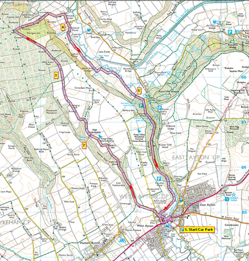

Route created using TrackLogs Digital Mapping
Image reproduced with kind permission of Ordnance Survey and Ordnance Survey of Northern Ireland.

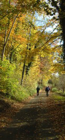
- (Start) Walk back down Wilson’s Lane to the main road. Turn left towards the bridge and when safe to do so, cross the road. Walk across the bridge over the R. Derwent and take the second right - Yedmandale Road. Walk up the road passing Yedmandale Terrace – ignore FP Forge valley right – continuing up to a cross roads. Go straight over still climbing steadily to reach a summit on a curious high embankment with low-lying ground on both sides – possibly as a result of quarrying many years ago. You will follow this quiet lane all the way up Yedmandale, where it serves just a couple of farms. After going through a gate (displaying Caravan Club notice) by Low Yedmandale the lane becomes wooded on both sides, being particularly picturesque in autumn. After about a mile the trees are left and the lane climbs round a double bend into open farmland to reach High Yedmandale.
- (1.9km/1Ľmiles) This is the location of the Caravan site, and a couple of holiday cottages. The property may well be ‘guarded’ by dogs and geese! Go through the gate & straight through the yard to another gate where the tarmac abruptly ends. Follow the track across the paddock, where there may be horses, exiting it by a stone stile by a gate. Here the tracks fork – take the left, dipping down into trees and up across open farmland with a hedge on your right. As you approach the expanse of Wykeham forest you will need to cut through a gap in the hedge and continue now with the hedge on your left and a new fence on your right. Walk along the edge of the forest (ignore BW left and FP right) to reach a forest track.
- (4.7km/3miles) Follow this track into the forest for about ľ mile (1km) ignoring other tracks L or R, until you reach a major intersection of forest drives. Turn right here (to pass a Moors to Sea cycle route SP). This track becomes a tarmac road and starts to descend with increasing steepness into the Derwent valley. There are panoramic views over Hackness village to Hackness Hall against the backdrop of Reasty Bank. As the gradient eases the road doubles round a bend to reach the hamlet of Wrench Green (Note the house with a first floor sun lounge overlooking a tennis court). Follow the road round to the right. If you want a break, there is seat by the Derwent Joinery workshop – otherwise continue straight on.
- (8.7km/5˝miles) Walk up past the houses and barns (now holiday cottages) to a gate opening onto the green slopes of the upper Derwent valley. There is a choice of paths here, the most straightforward being to follow the farm track that undulates along the hillside. At several places, old railway sleepers border this track and these make ideal seats for a break, with views across the valley. The track leads to the isolated North Stile cottage. As you approach the property, fork left off the track to pass below the house (as waymarked). Go over a stile and cross a dip where a new pond has been created and enter the next field. Turn down the field side to pick up the lower path along the bottom of the hillside. There are several boggy sections where springs issue from the hillside so pick the best route you can until you reach a stile into Scarwell Wood at the entrance to Forge Valley.
- (10.2km/6˝miles) Here you join a boardwalk path all the way down the valley. This boardwalk is being made wheelchair friendly with work still in progress at this northern end. This is a great improvement on the old boardwalk, much of which had suffered from flood damage, but can still be very slippy if wet and frosty. Once past the footbridge to the car-park it can be easy walking down the valley alongside the River Derwent. In fact there is a temptation to stride out and overlook the wildlife of this valley – particularly the birds. The boardwalk ends at a gate and stile where you enter riverside meadows for the final stretch into West Ayton. The path curves round below the ruin of Ayton Castle to a gate and Yedmendale Road. Turn downhill past the Terrace, but as a variation to the outward route, bear left into Mill Lane, passing the former water mill to regain the main road by the bridge. Cross the bridge into Easton Ayton and turn right into Wilson’s Lane to the carpark.
(14km/9miles)
Along the Way
Forge Valley Nature Reserve flanks the steep east and west facing slopes of the Derwent river valley. It is one of the best examples of mixed deciduous woodland in north-east England.The woods are named after a forge that used to operate in the area. Traditionally the woods were coppiced to provide charcoal for the forge which processed ore from locally mined ironstone. The woodland supports a rich population of breeding birds, including nuthatch, treecreeper, garden warbler, wood warbler, redstart and black-cap, while the river is home to otter, trout and crayfish.
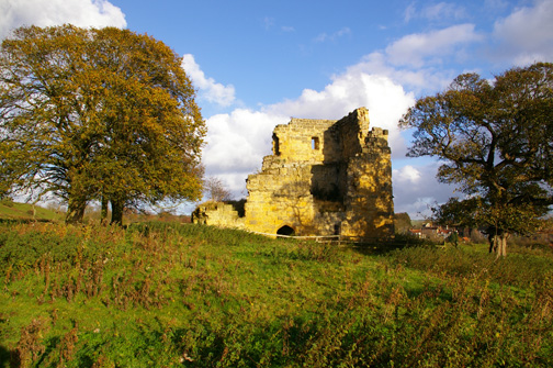
Ayton Castle is a late 14th century three storey stone tower house, with rib-vaulted chambers and twin mural stairs to give access to the upper floors. One corner stands to the height of the wall-head, where surviving corbels give evidence of a parapet and a corner turret. To the east are the remnants of the inner and outer bailey ramparts, with the grass covered foundations of an inner gateway and traces of fishponds.
Arnold Underwood (Feb 2007, with minor revisions Nov 2007)
|