|
NORTH & EAST YORKSHIRE - Wharram Percy
As featured in Country Walking Magazine April 2002
Lost in time, on the Yorkshire Wolds
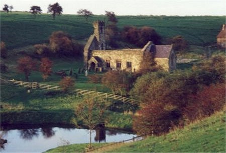
Wharram Percy is the best known of the many 'lost' villages of the Yorkshire Wolds. Changes in farming practice in the Middle Ages are thought to have lead to depopulation of the countryside, causing the wholesale abandonment of many settlements.On this walk, the approach to Wharram Percy from above Deep Dale gives a panoramic view over the site of this 'lost village'.

Fact File
|
Distance
|
13km (8 miles)
|
|
Time
|
4 hours
|
|
Map
|
OS Explorer 300 Howardian Hills & Malton
|
|
Start/Parking
|
Car Park for visitors to Wharram Percy medieval village, on minor road off the B1248, grid ref SE 867645 |
|
Terrain
|
Field paths, bridle-ways, and minor roads. Steep climb out of Thixendale.
|
|
nearest Town
|
Malton
|
|
Refreshments
|
Pub and Post Office in Thixendale.Teas served in the village hall on Sundays (11am-4pm) |
|
Toilets |
Thixendale village hall (for patrons only!)
|
|
Public Transport
|
|
|
Suitable for
|
for everyone, but some stiles can be awkward for dogs.
|
|
Stiles
|
5
|
- (Start) From the car park, set off south along the minor road towards Burdale. After 1km (1500yds) the road bends right then left. Here follow a bridleway, signed Centenary Way, through a gate with woodland on your right. Notice the fenced area in the woodland, enclosing one of the airshafts for Burdale Tunnel on the long-closed Driffield to Malton railway line.
- (1.2km, ¾ mile) Continue past the woodland for about 200m (220yds) and turn left at a bridleway sign. Walk down hill alongside the hedge for a further 200m and turn right by an indistinct way-mark into the adjacent field. Follow the contours along the field side to join a track leading down to Raisthorpe Manor. Look out for a sign at a gap in the hedge on the right where you bear right up along the edge of a new plantation. Beyond the plantation the path again keeps to the contour to the left of the hedge. At the field corner the path continues through trees on the site of a disused quarry and drops down to join a farm track. Follow this track downhill for about 200m (220yds) to the second field boundary.
- (3km, 1¾ miles) Turn right at a sign along this field side keeping the hedge on your right. This brings you to a gate at the top of the steep-sided Court Dale. If you spot any large birds of prey they could be Red Kites, which have been successfully re-introduced in this area. Pass through the gate and turn left to follow a narrow path along the top of the dale. As the dale opens out the path descends the hillside to a gate. Cross the track at the bottom and continue along Water Dale, initially on a bank. Drop down to a gate to enter a lane leading into Thixendale. Nestling in the row of cottages is The Cross Keys Inn, but if you prefer alternative refreshment try the PO or village hall further along the street.
- (5km, 3 miles) Walk through the village, passing the church and the old school, recently refurbished as the village hall, then fork right to follow the Wolds Way up Beamer Hill. It's quite a pull so you will be glad of the excuse to stop and look back over the village. You pass the village's TV aerials and as the path swings right you look down onto the road winding its way out of the village through Water Dale. If you haven't been tempted by lunch at the Cross Keys, this is a good spot for a break if the weather is fine.
- (6km, 3¾ miles) At the top of the bank bear left along a grassy path to a ladder stile over an electric fence. Continue forward to another stile, cross and turn left alongside the fence. Turn at the corner and keep along the field-side. After the next stile the ground drops more steeply and about halfway down the path crosses a stile in a new fence into the adjacent field. Continue down to the corner and pass through the footpath gate.(Open Access Information) There may be cattle accompanied by a bull hereabouts. Follow the path by a fence up a gully, which becomes steeper as you approach a gate at the top. After the gate head along the track taking to a narrow path straight through trees at the corner. You emerge from the trees at a junction of farm tracks.
- (7.5 km, 5 miles) Turn right, still following the Wolds Way. The path keeps to the field headland alongside North Plantation. At a gate your pass from cultivated land to pasture and here again there may well be cattle, including a bull. As you approach another gate in the corner, swing left along a faint path above Deep Dale to head for the ruined church and farmhouse at Wharram Percy village, now visible down the valley. If you are lucky you may also spot deer in this area. A sign indicates where you descend the valley side, and leads you unerringly down to a gate into the grounds of Wharram Percy. Walk round the pond towards the ruined church. Information boards explain the history of the site, which covers a large area of the hillside behind the church.
- (11km, 7 miles) Take time to explore the site then leave the village by the surfaced footpath past the deserted farmhouse. Go through a gate and cross the track-bed of the former Malton railway line. After a footbridge and another gate follow the path which climbs steadily back to the car park.
Along the Way
Although the start is less than 1km from the medieval village this walk saves the 'best till last'. The route follows a circuit of some of the best Wolds countryside by way of the delightful, remote village of Thixendale.
One theory behind the name is that it could be derived from the fact that six valleys converge here. The narrow valleys do mean that rooftop TV aerials are of no use to many homes in the village - so TV has to be 'piped' from aerials on the hillside. I wonder if satellite TV will make this system redundant?
The school, which until a few years ago served as a Youth Hostel, has been tastefully restored as the village hall. Information boards outside tell something of the history of the building and the village. Tea & cakes are available here on Sundays.
Arnold Underwood (Aug 2001), Revised April 2006, Feb 2008
|