|
EAST YORKSHIRE - Along the Southern Edge of the Yorkshire Wolds
Walking from Welton
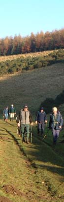
The gentle hills, tranquil dales and picturesque villages of the southern fringe of the Yorkshire Wolds make ideal walking country. This area is particularly attractive in autumn or early spring. Deer can often be seen on the edge of the woodland.
Fact File
|
Distance
|
15.5km/9½ miles (can be shortened to 13km, 8miles) |
|
Time
|
4¼ hours
|
|
Map
|
OS Explorer 294(Market Weighton & Yorkshire Wolds Central)
|
|
Start/Parking
|
Welton green
|
|
Terrain
|
Field paths, bridle-ways, and minor roads.
|
|
nearest Town
|
Hessle
|
|
Refreshments
|
Green Dragon Inn at Welton, Triton Inn at Brantingham |
|
Toilets |
none
|
|
Public Transport
|
East Yorkshire service 155 (Hull - Goole) |
|
Suitable for
|
everyone.
|
|
Stiles
|
5
|
- (Start) Head north away from the Green Dragon alongside the stream passing St Helen’s Church. At the crossroads continue ahead to follow the Dales Way into Dale Road. On the right you pass Cattle Well and then the former flourmill before entering the grassy Welton Dale by the millpond. After about ½mile you enter woodland. Continue on the main path climbing gradually to reach a stile and a concrete farm road. Cross the road to the bridleway opposite and turn left to walk parallel with the farm road up to a T-junction. Note through the trees on your left a mausoleum (most visible in winter months). Turn left to walk down the road (towards Welton) passing riding stables to reach a footpath into the woods on the right
- (2.5km, 1¾ miles) Follow the path through the plantation with views through the trees towards the River Humber. At a signpost you reach the top of the wooded Elloughton Dale. Turn left along the top of the dale. Do not follow the path down to the right but keep straight on down to the corner where you leave the wood to walk along a grassy hillside. Now clear of the trees there is a good view across Elloughton and Brough to the River Humber. The path drops down to meet the Elloughton Road. Turn right along the road, ignoring turnings left and right, to enter a bridle-way at a gate, straight ahead. An interesting notice on the gate states that this path is a bridleway for 1200m at which point horse riders & cyclists must turn back. The path passes a chapel cemetery and climbs gradually towards woodland. Continue on the main path, which swings right up through the woods, eventually to arrive at a kissing gate – it’s here, if you are on horseback, that you must turn back! Through the gate continue along the main path and turn left up steps just before another gate (marked private). The path weaves its way through bushes along the wooded ridge to reach a stile near the top of Spout Hill above Brantingham.
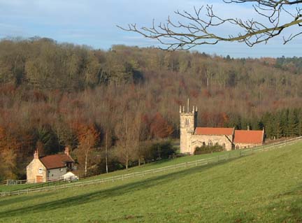
- (6.3km, 4 miles) This loop into Brantingham can be omitted, as you must return up Spout Hill to this point. To visit Brantingham, turn left down Spout Hill. Where the hill starts to get steeper cross a stile on the right to descend the field into Brantingham Dale. In this delightful setting sits Brantingham Church – probably the most photographed church in the region. From the church walk down the road into Brantingham village. To see more of this delightful village bear right to the pond. The Triton Inn is further through the village – continue from the pond past the village hall. Loop round back past the pond to the bottom of Spout Hill by the old village pump. At the pump, fork right to tackle the steady climb back up the hill.
- (8.5km, 5¼ miles) Continue up Spout Hill, which levels out to become a green lane along the edge of Long Plantation. Tree trunks restricting access mean that this green lane is slowly recovering from damage caused by off-road vehicles. The green lane merges with a minor road from Elloughton, which is followed down to a road junction. Cross over to continue along the Wolds Way. Being a bridleway, this next stretch can get churned up by horses. Turn right still following the Wolds Way towards Wauldby Manor, which reached after about ½ mile. Here, the old farm buildings have all been tastefully restored into rather exclusive homes. At the lane turn left, through a gate and then right past the pond. Through the trees across the pond can be seen the tiny church in the grounds of Wauldby Manor. Continue along the field side to reach the concrete access road encountered earlier in the walk.
- (12.5km, 7¾ miles) Turn left and then right, crossing the road, to follow a path along the top of Welton Dale. Once clear of the woodland you have a view across Welton Dale towards the Humber. On your left newly erected security-fencing heralds the expansion of the vast Melton chalk quarry. Signs warn of blasting, which may take place on weekdays. Keep alongside the perimeter fence round the corner to reach the end of lane at a vehicle barrier. Turn right and walk down the lane into Welton. Be aware that local joy riders like to ‘burn’ up and down this track – but as you near the village a 20mph speed restriction is imposed! Cross the road junction to return past the church to the Green Dragon. (15.5km, 9½ miles)
Along the Way
Welton is a picturesque village with some fine houses set around the village green, with its stream and pond. At one end of the green stands the attractive church of St. Helen’s whilst at the other is the Green Dragon inn, where it is reputed that Dick Turpin was arrested.
Brantingham is another attractive village with a large duck pond. The church is situated out of the village in Brantingham Dale.
Arnold Underwood (Feb 2004)
|