Dales Trails


|
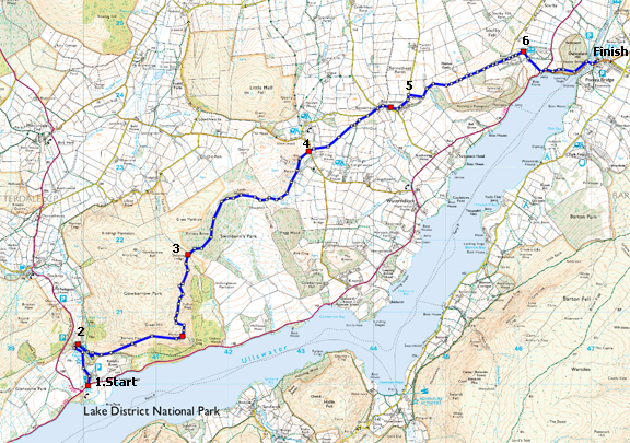
Ullswater View: Aira Force to Pooley Bridge 11.2km (7 miles)
|
| Distance | 11.2km/7 miles |
| Time | 3˝ hours |
| Map | OS Explorer OL5 English Lakes |
| Start/Parking | Pooley Bridge (pay-and-display car park; Aira Force car park (National Trust) Grid ref: NY 400200 |
| Terrain | Fellside, forest and field paths. A steady climb onto Gowbarrow Fell. Can be boggy in places | Grade | *** Moderate |
| nearest Town | Penrith |
| Refreshments | Seasonal tea-room at Aira Force (NT), pubs and cafés in Pooley Bridge |
| Toilets | Aira Force |
| Public Transport | Stagecoach North West 108 bus (Penrith – Patterdale) links Aira Force and Pooley Bridge (Mon - Sat) every 2 hours |
| Suitable for | for all |
| Stiles | 6 |
![]()
Route created using Mapyx QUO Digital Mapping
Image reproduced with kind permission of Ordnance Survey and Ordnance Survey of Northern Ireland.
![]()
-
Catch the Stagecoach North West 108 bus from Pooley Bridge for the 20min ride to Aira Force
- (Start) At Aira Force car park leave by the gate at top and follow a path heading towards the waterfall, keeping left of Aira Beck. The path climbs steadily with the beck far below. After heavy rain a cloud of spray may be seen through the trees as you approach the falls. When Aira Force comes into view take the right-hand path which descends steep steps down to the pool at the bottom of the waterfall. The view up the waterfall is dramatic, with the high level footbridge over the top, set against the sky.
- (0.8km/˝mile) Cross the footbridge below the waterfall and follow the path back along the other side of the beck. This path climbs steadily up the wooded side of the gorge and the beck is soon far below. Just past a large conifer swing right to come alongside a fence. Go right through a gate into the open countryside of Gowbarrow Park. The trend now is onwards and upwards climbing the flank of Gowbarrow Fell with views opening out across Ullswater and back towards Glenridding and Helvelyn. Keep left at a fork in the path to continue upwards towards Yew Crag. The path, clear but narrow in places with a steep drop on your right, contours round the side of the Fell giving views along the lake towards Pooley Bridge, with the Pennines in the far distance.
- (3.6km/2Ľmiles) By a ruin, bear right through a gate in the wall and cross boggy ground to a footbridge and a stile into Swinburn Park. A clear path takes you through mixed woodland. Leaving the woods at Low Meldrum, the route drops down with Watermillock church visible ahead. The path swings north below the hillside across boggy ground and passes the Rectory to arrive at a footpath gate and a minor road.
- (6.0km/3ľ miles) Cross straight over into more fields and maintain direction with more stiles and boggy ground to contend with. The route then climbs diagonally up a hillside above a copse through gates to a minor road. Walk along this lane into the hamlet of Bennethead. Follow the road round and take the left, higher, road at the fork. This lane climbs through woodland above Wreay round into open country.
- (8.0km/5 miles) From the lane turn right down a farm road. Concessionary paths, indicated by green waymarks, are now followed to Waterfoot. Much new building has taken place here, but press on past the barns crossing a concrete bridge to join a tractor track. Turn left along this track which passes woodland as it crosses Ramps Beck. The track climbs up round a field to a muddy gateway by a stone barn. A short detour left up the hillside brings you to Maiden Castle. Back at the barn the trend is gradually downhill along the side of fields from stile to stile. These fields can be quite wet. The Pennines are visible in the far distance. At the bottom, join a track by Waterfoot Farm and bear right towards a caravan park.
- (9.6km/6 miles)The way through the caravan site is private, but a public footpath goes off to the right just past the buildings, a former hotel now the site clubhouse, and continues through fields to reach the A592 road. Cross over and head towards Pooley Bridge, keeping to a path along the bank on the left then through woods. For the bus stop by the Jetty, drop down to a gate onto the road, otherwise continue through the woods to the Bridge and village centre.
Along the Way
Aira Force
The stream which flows over the waterfall is Aira Beck, which rises on the upper slopes of Stybarrow Dodd at a height of 2,362 ft and flows north-easterly before turning south to flow into Ullswater. One kilometre before entering the lake, the beck makes the 66 ft leap down a rocky ravine at the falls known as Aira Force.
Aira Force lies on land owned by the National Trust since 1906. The Trust has provided facilities, such as car parking, disabled access, graded paths, and viewing platforms to make Aira Force one of the most famous and most visited waterfalls in the Lake District. Small arched bridges span the stream above and below the falls giving spectacular views.
Arnold Underwood (April 2011)
Arnold Underwood