
|
NORTH YORKSHIRE - Thornton-le-Dale - 15km (9Ẅmiles)
'To the Woods'
Thornton-le-Dale is a picturesque village on the main A170 Scarborough road, a couple of miles east of Pickering. With a large car park and excellent bus links, particularly in the summer when the Moorsbus network is operating, it is an ideal base from which to explore the area.
This walk follows Thornton Beck into the heart of Dalby Forest and the new Dalby Forest Visitor Centre, returning through forest and farmland.
As featured in Country Walking magazine - May 2009
Fact File
|
Distance
|
15km (9Ẅmiles)
|
|
Terrain
|
Field paths, forest tracks & minor road. Can be muddy in places.
|
|
Time
|
4 hours
|
|
Stiles
|
10
|
|
Grading
|
*** Moderate
|
|
Suitable for
|
all but care needed on the Forest Drive (traffic) and Howl Wood (difficult walking conditions)
|
|
Start/Parking
|
Thornton-le-Dale |
|
Nearest Town
|
Pickering
|
|
Refreshments
|
Thornton-le-Dale (Pubs & tearooms), Dalby Forest visitor centre (Purple Mountain Café)
|
|
Toilets |
Thornton-le-Dale and Dalby Forest Visitor Centre
|
|
Public Transport
|
Thornton-le-Dale is served by Yorkshire Coastliner 840/2, Scarborough & District 128 (both part of the Moorsbus network Easter October) and Moorsbus M6 (into Dalby Forest)
|
|
Map
|
OS Explorer OL27 North York Moors (East)
|

Route created using TrackLogs Digital Mapping
Image reproduced with kind permission of Ordnance Survey and Ordnance Survey of Northern Ireland.

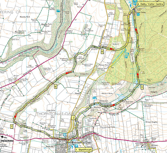
- (Start) From the car park take the footpath through wall by the toilets and go past the pond, over the footbridge to the green at the centre of the village. Turn right along the pavement and when safe to do so cross over the busy main road. Continue past almshouses and follow the path left by the stream and past a picturesque thatched cottage. At Mill Road turn left and walk along the roadside to reach the former mill, now converted into apartments. A new footpath on the right takes you round the perimeter of the grounds.
- (1.1km/ ẅ mile) After skirting the grounds, the path turns right and follows Thornton Beck upstream through green pastures to Low Farm at Ellerburn. Bear left through the farmyard to the road by the tiny, squat church. Turn right along the lane past the few cottages the make up this hamlet. At the fishponds take the right fork and head along the track to High Paper Mill Farm. Go through a couple of gates towards Dalby Forest. At another gate you enter the forest and the green pastures give way to mixed woodland
- (3.8km/2ỳ miles) A clear track continues up the Dale, with the hillside to the right densely wooded, initially with broad-leaved trees but then with darker conifers. Down to your left the dale is more open. Numerous forest trails lead off through the trees, many popular with cyclists, so beware! You should keep to the main track which heads unerringly up the dale to the Forestry village of Low Dalby. Cross the village road to continue along the path to the attractive Coutyard Complex. Here you will find toilets, café, craft shops, cycle hire etc. The new Dalby Forest Visitor Centre is a little further on across the main carpark. Facilities at the centre include an information desk, Forestry Commission shop, exhibition area, education meeting room, external and internal toilets and Treetops Restaurant with terrace.
- (6.4km/4 miles) From the visitor centre walk down to the road (Forest Drive) crossing the bridge over the beck, and head up hill. Its a steady gradient up the road for about 1km (ẅ mile), but to compensate there are good views back across the valley to Low Dalby and the forest beyond. However, take care as this road can be pretty busy, particularly at weekends. Once round a bend take extra care here a narrow path strikes off right up through the trees. Its position is indicated by a waymark on a post on the other side of the road. After a short climb this path crosses a track before merging with another path which leads to a crossing of tracks where there is a seat. Continue straight on here and after a particularly wet patch you come to the edge of the wood and enter farmland. Walk up the side of the field to a gate and the road up from Thornton Dale.
- (8.6km/5Ẅmiles) Go left then right down the side of a plantation, descending into a shallow valley. Through a gate bear left diagonally up the side to a bridle gate in the fence. The map shows the path maintaining direction across the field to the opposite corner, but the adopted route appears to be left and round two sides of the field. At the corner, overlooking Low Kingthorpe farm, descend a slippery slope to a gate. Cross a paddock to another gate and turn right into the farmyard. Walk through the yard and turn left round the buildings to a gate opening into Howl Dale. Walk down this grassy dale ignoring any tracks off to the left or right, until the grass abruptly ends at Howl Wood. Cross a stile in the bottom corner and drop down to join a forest track.
- (11km/6ẅmiles ) It is now a simple matter of following this track down this wooded dale. However, it is not that simple, because in recent years there has been much forestry activity, and the track has become deeply rutted by heavy machinery. These ruts are likely to be waterlogged which with the added hazards of felled trees and logs, make this section quite tedious. Its a long mile to the bottom corner of the dale where you turn left, and with relief, leave the assault course. Ignore a footpath right and continue up the track to a gate which was hidden by a fallen tree on my last visit.
- (13km/8ỳmiles) Cross a field to a gate by a former farm at Hagg House which has undergone extensive renovation in the last year. Cross the driveway to a new gate and climb up the bank and steps through trees into a field. Walk down the side of this field to a farm track. Turn right down the track then soon go left over a stile in the hedge. Cross two cultivated fields from stile to stile, then a shallow valley, and finally diagonally cross another field to a stile by the A170 road. Cross the road with care and walk down the pavement back into Thornton-le-Dale, noting the Motor Museum at the petrol station. (15.1km/9Ẅmiles)
Along the Way
Numerous mills were operated in the Thornton & Ellerburn area for various purposes; fulling, paper-making, down to the Burgess family milling flour.
The main Thornton manor passed into the hands of Richard, first Viscount Lumley, through his marriage to Elizabeth Sandys, a granddaughter of the forth Lord Latimer. When her son died in 1656 she founded a charity for the building of alms houses & a grammar school at Thornton
Dalby Forest is situated on the southern slopes of the North York Moors National Park. The southern part of the forest is divided by a number of valleys creating a 'Rigg and Dale' landscape whilst to the north the forest sits on the upland plateau. Although comprising mostly pines and spruces there are many broadleaf trees such as oak, beech, ash, alder and hazel both in the valleys and on the 'Riggs'.
St Hilda's Church, Ellerburn.
Dating from c.1150, the present stone church reveals the remains of 8th and 9th century Celtic crosses built into its walls, along with many interesting and symbolic carvings.
 Arnold Underwood with Leven Walking Club (April 2006, updated Dec 2007)
|
