|
Lincolnshire Wolds - Walesby & Tealby 16km (10miles)
'Viking Ways'
From Willingham Woods near Market Rasen, this route takes in the picturesque villages of Walesby and Tealby. From the Rambler's Church overlooking Walesby, the Viking Way is followed along the Lincolnshire Wolds into Tealby.
Although not subject to the recent 'Open Access' laws, this part of the Lincolnshire Wolds has numerous local 'Countryside Access' agreements with many permissive paths and open access areas which do not show on OS Maps. Details can be found on the DEFRA website - DEFRA Walks & Rides
Fact File
|
Distance
|
16km (10 miles)
|
|
Terrain
|
Forest tracks, field paths & bridleways
|
|
Time
|
4Ẅ hours
|
|
Stiles
|
9
|
|
Grading
|
*** Moderate
|
|
Suitable for
|
all but can be muddy in the forest and near Walesby
|
|
Start/Parking
|
Willingham Woods, on A631 1 mile east of Market Rasen (grid.ref: TF 138 884) |
|
Nearest Town
|
Market Rasen
|
|
Refreshments
|
Walesby - tearoom; Tealby - The Kings Head Inn, The Olde Barn Inn, and Tearooms
|
|
Toilets |
Willingham Woods car park
|
|
Public Transport
|
Market Rasen is on the main Lincoln Cleethorpes bus route (Road Car service 3). Bus services to surrounding villages are very limited.
Also Central Trains, Lincoln Grimsby services call at Market Rasen
|
|
Map
|
OS Explorer 282 Lincolnshire Wolds North
|
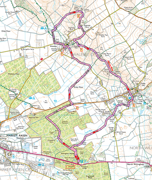

Route created using TrackLogs Digital Mapping
Image reproduced with kind permission of Ordnance Survey and Ordnance Survey of Northern Ireland.

- (Start) Head into the woods from main parking/picnic area. Here, the path joins a forest road. Keep left at the first fork then turn left signed Forest Office. Bear right past the office where a notice board explains the history of the area. Continue into woods passing a cottage on your right. Keep straight on at junctions. Where the main surfaced track turns right, again continue straight on along narrow path (can be muddy) through the trees. At a crossing of footpaths (signpost) turn right, following a line of electricity poles. Keep straight on at any intersections, eventually falling out of the wood at a bend on the Tealby road. Cross to the pavement and walk left back to the entrance drive to Risby Park Farm.
- (3.0km/ 1ẅ miles). Walk along the farm road and across the grass between farmhouse and barns (now an Equine study centre for the University of Lincoln) bearing right to follow a track for a mile to the Walesby road. Ahead, the ridge of the Lincolnshire Wolds, our return route, extends from North to South. At the road turn left towards Walesby. Numerous notices give details of permissive paths and access under the Countryside Stewardship scheme. Ignore these to eventually come to a gate and public footpath sign on the right. Enter the rough pasture and head diagonally left across the field, skirting the perimeter hedge of a large house, recently renovated. Head across somewhat boggy ground towards Walesby. You reach a footbridge by the rear gardens of houses in the village. The path goes left and then up the side of the gardens emerging at a small wall-stile in the centre of Walesby. Turn left and walk along to the church here there are couple of benches, so its an ideal place for a short break. (Signs indicate that there is a tea-room further along)
- (5.9km/ 3Ẅ miles). Walk down the path through the churchyard to the lower road. Turn left and walk along the pavement. Just beyond the last house you come to an access drive to Mill Farm caravan site. Turn right along this driveway, bearing right at the fork to cross a cattle grid. Either side of the driveway is now given over to paddocks for horses. As you near the buildings swing left to cross a sleeper bridge over the stream, then right, behind the old mill buildings. Enter fields and head along a shallow valley eventually curving round and up towards Otby House, visible on the hill ahead. Walk past the house to a gate onto a farm road.
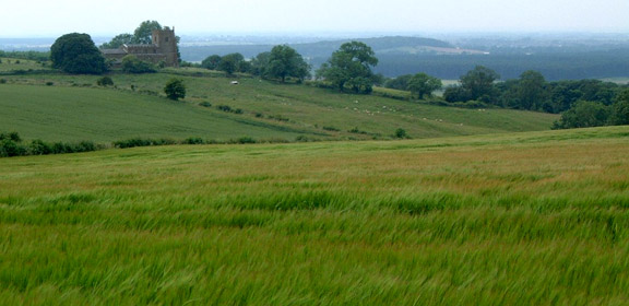
- (8.1km/ 5 miles). Turn right down the lane passing between a cottage and its landscaped garden. At the next junction, turn left and just before gates (private drive except for footpath), go into the field on the right continuing along field side and round the corner. As you top the rise, the hilltop Ramblers Church at Walesby is prominent on the next hill. At the road turn right and walk down towards Walesby. Just before the 30mph sign a stile provides access to the field below the old church. Follow a permissive path up the hillside to cross another stile near the church. The church and its surroundings make another suitable spot for a break.
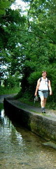
- (9.7km/ 6 miles). From Walesby Church you now head south on the Viking Way towards Tealby. This path has been much improved in recent years with clear signs, and gates replacing many stiles. The path drops steeply down alongside a new high fence the reason deer are now kept on the upper part of this dale. Then its steeply up the other side and along to Risby. Cross the road and continue forward dipping down the hillside to pass a pond before climbing back up to the side of a wood. At the end of the wood you emerge by Castle Farm, with its interesting fortified farm house, now looking a bit worse for wear. Walk down the dip, past piles of chalk and along the bottom of fields towards Tealby. Take the right path at a fork, to reach Teably village. Cross to the footpath opposite, which leads you across an open pasture a common, with cattle grazing in the centre of the village. At the lower road turn right. There is a interesting craft shop on the left and a fascinating display of flowers right. Opposite is The Kings Head, which welcomes walkers. It's an interesting building, being thatched, and claims to be the oldest thatched pub in Lincolnshire.
- (12.5km/7ẅ miles). Walk along the road to the right of the pub and take the left fork. At the edge of the village (FPS) go through a gate/stile on the right into a field and walk alongside the River Rase. At the far corner of the field the path squeezes between the river and the wire fence surrounding a sewage works! Ignore a path to the right and leave the sewage works behind and arrive at another junction of paths. Either will eventually take you to Tealby Thorpe I took the one left through into a field, bearing right to head across towards the hamlet. Passing to the right of buildings you reach a road, which here shares its course with the river! Cross the road and the river and follow the footpath opposite into fields. Head across the field to its corner and enter a vaste area under cultivation. The path is clearly defined through the crops, but it seems to take for ever to cross. Eventually you arrive near Dairy Farm and cross a stile to skirt left round the farm. Keep on the field side of the fence until you reach the end of the drive where you cross a stile. Walk down the farm road to its junction with a forest road and there turn left. Walk back along this road, passing the turn to the Forest Office, keeping left at a fork before finally taking to the path through the trees back to the car park. (16km/10miles)
Along the Way
Tealby
Tealby is a quiet rural village with many attractive attributes it is said to be the prettiest village in Linolnshire and is situated in the Lincolnshire Wolds Area of Outstanding Natural Beauty. The Viking Way, a long distance footpath from the Humber to Oakham in Rutland, passes through the village.
All Saints Church, Tealby, which dominates the village, dates from the 12th century. The Church is built of orange-brown Tealby ironstone, the oldest parts being the west doorway and the lower part of the tower. There are many interesting features, including the memorials to the Tennyson family. George and Mary Tennyson were the grandparents of Alfred Lord Tennyson, the Poet Laureate.
Walesby
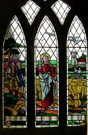
The old village of Walesby was sited on the hilltop and All Saints Church there, dates from the 12th century. Over the centuries, the hilltop location for the village was abandoned in favour of a site at the bottom of the hill. All Saints was still the parish church, but a temporary church had been built in the new village. In 1914, with the building of the new Parish Church in Walesby village, the church on the hill became disused and it fell into disrepair. However, the old church was renovated in the 1930s and became the meeting place for various local groups including the Ramblers. It became known as the "Rambler's Church", and the stained-glass window depicting walkers and (for some reason) cyclists, was donated by the local Ramblers in 1951.
Arnold Underwood (June 2003, May 2007)
|