|
|
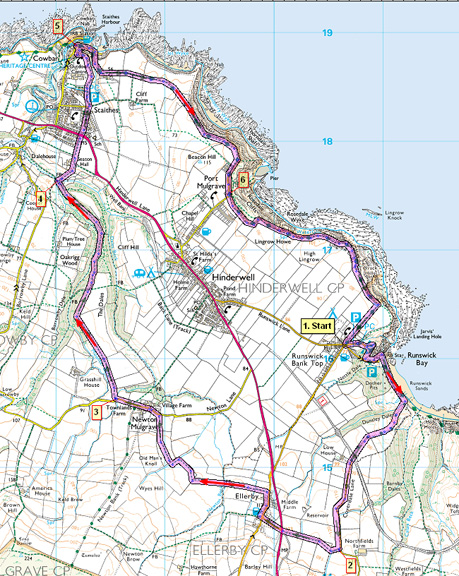
NORTH YORKSHIRE COAST
Smugglers' Coast - Runswick Bay, Staithes & Port Mulgrave
This route loops inland from Runswick Bay round to Staithes. Nowadays Staithes is a peaceful North East fishing village, tucked away and well protected from the sea. But it has had a chequered history with tales of great storms, smugglers and pirates, the Armada, Captain Cook, great fishing fleets, and the ironstone industry.The return to Runswick Bay is along the cliff-top Cleveland Way above Port Mulgrave.
Fact File
|
Distance
|
14.4km/9 miles |
|
Time
|
4 Ẅ hours
|
|
Grade
|
*** (moderate)
|
|
Map
|
OS Explorer OL 27 (North York Moors East)
|
|
Start/Parking
|
Runswick Bank Top car park
|
|
Terrain
|
Field paths & farm tracks, exposed cliff-top path
|
|
Nearest Town
|
Whitby
|
|
Refreshments
|
Pubs at Ellerby, Staithes, and Runswick Bay
|
|
Toilets |
at car park
|
|
Public Transport
|
Scarborough Whitby Middlesbrough service Arriva 56/X56 serves Runswick Bay and Staithes.
|
|
Suitable for
|
keen walkers
|
|
Stiles
|
15
|

Route created using TrackLogs Digital Mapping
Image reproduced with kind permission of Ordnance Survey and Ordnance Survey of Northern Ireland.

- (Start) From the car park take the path which winds its way steeply down to the beach. Walk south along the beach for about 100yds looking out for a footpath on the right. This is part hidden behind a large concrete block, where there is a gate. A narrow path picks its way, steeply in places, up the hillside through scrubby hawthorn. Choose that best route for you until you emerge onto the open hillside with views back across the bay. Continue up the field, where there may well be cattle, to a gate at the top. Go through and follow a track across undulating farmland. After crossing the line of a long-gone railway and the entrance to Low House farm, the lane becomes metalled.
- (2.8km/1ẅmiles) Just before a left bend a footpath sign indicates our route, right, into fields. Follow the waymarks from field to field to emerge on the main coast road opposite the turn for Ellerby. Cross with care and walk into the village bearing right past the Ellerby Hotel. At the far end of the village look out for a footpath sign pointing left into fields. Head straight down the field to a stile and footbridge. Continue along the side of the next field and just along from the corner the path drops down through trees to cross another footbridge over Newton Beck. Two fields on, the right of way bears right to cross a stile in a wire fence. Walk alongside the fence to a gate. Go left through the gate (back into the field you were in!) then right through a gateway and follow a farm track down to Newton Mulgrave. Turn left and walk through this small village.
- (5.6km/3Ẅmiles) At a left bend in the road, take a footpath right (through field gate or over stile). The path follows a track along a ridge between two wooded dales. Hinderwell village is visible over fields to the right. This is a pleasant walk trending downhill through a mix of woodland and clearings which would make an ideal sheltered spot for a break. Eventually the path drops steeply down to where the two dales merge. Cross a sleeper bridge over the beck.
- (8.0km/5miles) Here, double back right towards the caravan site entrance to find a footpath up the bank. This climbs steeply out of the valley finally levelling out by Seaton Hall and follows a field side to the main road on the outskirts of the newer part of Staithes. Cross over into a council estate and follow the road straight ahead. Bear right towards a corner of the estate where there is access to some garages. Walk past these to reach another road next to the stone abutments of an old railway bridge. Go right through bridge and immediately left onto a narrow path. Ignore any other paths branching off, and this path suddenly brings you out onto the cliff-top overlooking the old picturesque part of Staithes. A surprise view if there ever was one. There are two benches just round the corner making this a good place for a break albeit a bit exposed.
- (9.6km/6miles) From the seats walk down steps through the old part of the village to the harbour side, where there is a pub another good place for a break! Unfortunately the only way from here is up! So turn away from the harbour to follow the Cleveland Way, sign-posted Port Mulgrave 1 and Runswick Bay. Its a long haul up past a pig farm and over the headland. Eventually the path rejoins the cliff top as far as the tiny settlement of Port Mulgrave.
- (12.0km/7Ẅmiles) At Port Mulgrave, an information board give details of the history of this bay and its former harbour. Now simply continue along the Cleveland Way on the cliff-top, taking care in places where erosion has occurred. At a corner, keep to the Cleveland Way as it turns right and walk along a field side back to Runswick Bank Top.(14.4km/9miles)
Along the Way
The original village of Runswick Bay lay slightly to the north on the other side of Lingrow Beck but in one tragic night in 1664 the village slid into the sea. Many of the villagers were attending a wake when a latecomer noticed the steps to the house slip away under his feet. Looking out, the alarmed mourners saw the ground slide several feet down the cliff. By morning every house had fallen into the sea, except one the house of the dead man!
The village was rebuilt but the land has continued to slip, so in 1970 a new sea wall built to prevent further damage. 1962 saw the opening of the new road, leaving the old one as a pleasant winding path from the top car park.
Staithes is famous for its past fishing industry and hundreds of years of mineral production, an industry that continues to the present day. The Boulby Potash mine being one of the deepest in the United Kingdom and one of the tidiest being located within the North York Moors National Park.
Staithes was once one of the largest fishing ports on the north east coast of England. In its heyday there were just under 300 men engaged in fishing with three trains a week, from its station on the Whitby, Redcar and Middlesbrough Union Railway, delivering the catch to the rest of the United Kingdom.
The locally built boats, known as Cobles and larger ones known as "Five-Man", were launched and landed on the beach
In 1744 James Cook moved to Staithes to work in the shop of William Sanderson. In those days of poor roads and no railway the best form of long distance transportation was by sea making Staithes a very busy little port. It was not long before the interests of 16 year old James moved from being a farmer or a shop keeper to that of becoming a seaman. The rest as they say is history and James's life was to take him far away from his humble beginnings in North Yorkshire.

Port Mulgrave was once a thriving community where locally mined ironstone shipped from its own harbour.
A tunnel connected Port Mulgrave through the hill to Dalehouse so that ironstone from the nearby Grinkle mine could be brought directly to harbour. The beach at Port Mulgrave is one of the best locations for collecting fossils in Yorkshire. However access is difficult.
Arnold Underwood/LWC (Sept 2007)
|
