
|
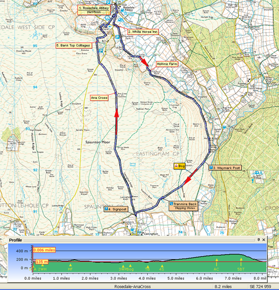
NORTH YORK MOORS - Rosedale (West Side) - 13.2km (8ỳ miles)
'Rosedale & Ana Cross'
A generally straightforward walk using farm tracks and moorland paths. Choose a clear day and there should be no problems with navigation across the moor.
It can be boggy on Askew Rigg and the steep descent back down into Rosedale can be wet and slippery
Fact File
|
Distance
|
13.2km (8ỳ miles)
|
|
Terrain
|
Moorland, field paths and forest tracks & bridleways. Steep ascent and descent
|
|
Time
|
4 hours
|
|
Stiles
|
5
|
|
Grading
|
*** Moderate
|
|
Suitable for
|
all but can be boggy in one or two places!
|
|
Start/Parking
|
Car parks near Milburn Arms at Rosedale Abbey (grid.ref: SE 724 959) |
|
Nearest Town
|
Pickering
|
|
Refreshments
|
White Horse Inn at Rosedale Abbey (The Milburn Arms is closed at present). Tearooms at Rosedale Abbey
|
|
Toilets |
At start/finish
|
|
Public Transport
|
Moorsbus from Pickering (Sundays & Bank Hols, Easter October)
|
|
Map
|
OS Explorer OL27 North York Moors East
|

Route created using TrackLogs Digital Mapping
Image reproduced with kind permission of Ordnance Survey and Ordnance Survey of Northern Ireland.

- (Start) Head south out of the village along the roadside pavement then cross over and take the right turn, the road to Hutton-le-Hole, passing the caravan site, and start the climb up Rosedale Bank. Be aware of traffic as you walk round a bend. Fortunately it is not far up the hill to the White Horse Inn where this route turns left.
- (0.5km/ ỳ mile) The track in front of the Inn will be followed for about 2miles down the valley passing isolated farms and cottages. At Hollins Farm the track bears right keeping by the boundary wall. Stay with wall, not the track that climbs up onto the moor. Your route continues down the valley through heather and bracken with hidden rocks and boulders to trap the unwary. Nearing Hartoft Bridge you pass an information plaque at the site of an ancient glass works
- (4.8m/3 miles) Fork right at a yellow waymark to follow a faint path out of the valley onto Askew Rigg. There can be boggy areas on the rigg where you will need to tread with care. Cross a moorland track (providing access for grouse shooting) and descend steeply to Tranmire Beck and cross with care using the stones if necessary. This gill provides a sheltered spot for a break. From the beck there is now a stiff climb onto moor towards Lastingham. At cross-sign and seat its about half a mile down into village for the pub.
- (7.2km/4Ẅ miles) Otherwise turn right to follow a clear path across Spaunton Moor to Ana Cross. From the cross, continue north to the Hutton-Rosedale road. Cross straight over onto a track through old mine workings and drop down towards Bank Top Cottages with views across Rosedale. Descend the hillside to the left of the cottages, past a tree, bearing left between fences down to a stile.
- (11.6km/7ỳmiles) It can be slippery on the next section as the path zig-zags steeply down to a ladder stile take care its bigger drop on other side! Cross another stile in a hedge into Red House golf course. Follow the waymarks and posts across and down past the clubhouse. Leave by the gate or stile and cross the road to another stile. Walk down side of a rough boggy field which may contain cattle. At the bottom corner, a stile and narrow steps by cottages brings you back onto the road. Walk down the hill, turning left at the bottom retracing your steps back past the green to your car.
Along the Way
RosedaleA century ago, the moors above the peaceful settlement of Rosedale Abbey were alive with industry. There was iron in 'them there hills'. The ore was dried in kilns and then taken by the Rosedale Ironstone Railway to iron works in Middlesbrough. There is evidence of mining and quarrying going on in the valley for hundreds of years previous. Then materials were transported along the rough valley road, which is the track followed on the return leg of this walk from Hartoft. Much of the medieval working was controlled by the Abbot of St. Mary's Abbey in York, which owned much of the valley. There was also a Cistercian Nunnery, of which very little evidence remains, in the village which may have had connections with the Abbey in York. 19th century building work revealed signs of a medieval iron works near to the nunnery site.
Today the major industries of this dale are farming, forestry, and tourism.

Arnold Underwood (July 2012)
|
