

|
NORTH YORKSHIRE MOORS - Roseberry Revisited
Roseberry Topping & Highcliff Nab
A variation on the walk featured a couple of years ago. This is a classic walk over undulating heather moorland, taking in the distinctive conical hill of Roseberry Topping, then via Hutton Village to the viewpoint at Highcliff Nab, and returning by way of Captain Cook's Monument.
As featured in May 2008 Country Walking Magazine
Fact File
|
Distance
|
15.5km/9˝ miles |
|
Time
|
4 hours
|
|
Grade
|
**** (strenuous)
|
|
Map
|
OS Explorer OL 26 (North York Moors West)
|
|
Start/Parking
|
Gribdale (grid ref NZ 592110)
|
|
Terrain
|
Field & moorland paths, tracks & minor roads
|
|
Nearest Town
|
Great Ayton, Stokesley
|
|
Refreshments
|
none (there may be an ice cream van at Gribdale in summer)
|
|
Toilets |
none
|
|
Public Transport
|
None; but Arriva NE buses serve Newton-under-Roseberry, from where you can climb Roseberry Topping to join the route at point 2. Also, Northern Rail Esk Valley trains call at Great Ayton station
|
|
Suitable for
|
strong walkers
|
|
Stiles
|
4
|

Route created using TrackLogs Digital Mapping
Image reproduced with kind permission of Ordnance Survey and Ordnance Survey of Northern Ireland.

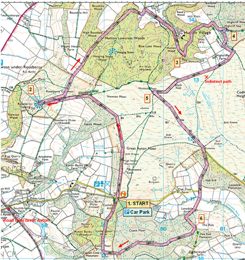
- (Start) Head north on the Cleveland Way, climbing steeply onto Great Ayton Moor and walk alongside a wall. Once past Intake Plantation, Roseberry Topping comes into view left over the wall. About 2km from the start go through a gate in the wall corner and drop down to Roseberry Common. Continue up the steep steps to the summit (320m). There are panoramic views extending from Capt Cook’s monument in the south, to the Cleveland Hills at Clay Bank and over Tees-side to the north.
- (2.8km, 1ľmiles) Retrace your steps down to the common where numerous paths radiate through the bracken. Take the wider path heading diagonally left (north-east). This swings round to enter woodland through which you follow the main path for about 1.5km. This path trends gradually down to emerge from the trees overlooking parkland. Here cut left, down the field to a gate and the road, opposite the entrance to Hutton Hall. Turn right up the road towards Hutton Village – a one-street, rather exclusive village tucked under the northern wooded slopes of the moors. Large properties border the street as far as a gate. Beyond this, a track climbs steadily up through the trees.
- (6.4km, 4miles) At the top keep to the main track which doubles back on itself then contours round the hillside. A cycle route and the Tees Link path both come this way. Keep left at a fork (right is to Highcliffe Farm) following the main track, which emerges from the trees to reveal Highcliff Nab dominating the view ahead. Go through a gate and turn uphill towards the crags. When level with crags a path cuts left towards them. The Nab is good place for lunch with panoramic views over Guisborough and across to Redcar and the North Sea.
- (7.6km, 4ľmiles) From the crags skirt back round to the west. Notice the metal signpost, complete with ‘rucksack’, where the Tees Link path leaves the Cleveland Way. Head down through the trees to a gate opening onto a patchwork of fields surrounding Highcliffe Farm. Follow the waymarks through more gates until finally emerging onto the moor. Turn right (Cleveland Way) and follow the well-trod path south alongside the wall past the farm. In places the ground is boggy, but flagstones have been laid so the going is generally good. Continue on the main path, which climbs to meet another track on Percy Cross Rigg.
- (9.6km, 6miles) Turn left here left and follow this track along the ridge to a gate, beyond which commences a tarmac road. Immediately turn right through another gate and head downhill on a track that has been severely eroded by heavy rain. Capt Cook’s monument is now visible in the distance above the trees on the next hill. At the bottom, the track meets a minor road which you follow straight ahead, up hill and round a bend through the trees.
- (12.4km, 7ľmiles) At the top you meet up with the Cleveland Way again. Turn right and head due west along the wooded fringes of Coate Moor. One final short but sharp climb brings you up onto a plateau upon which sits Captain Cook’s Monument. Once again there are panoramic views all round – including Roseberry Topping and Highcliff Nab. From the monument head north over Easby Moor and down through woodland to the car park in Gribdale

Along the Way
James Cook was born on Oct 27th 1728 in the village of Marton-in-Cleveland, now a suburb of Middlesbrough, where his father worked as a farm labourer.
When a small boy, the Cook family moved to Aireyholme Farm, three miles from Great Ayton. The nearby Roseberry Topping, prominent against the sky, was among the first of James Cook’s many conquests. In later life as Captain Cook, he was destined to cross the oceans of the world on his voyages of discovery.
Until 1914, the Roseberry summit resembled a sugarloaf, but a geological fault, possibly aided by nearby alum and ironstone mining, caused its collapse. The area immediately below the summit is still extensively pitted and scarred from the former mine works.
The summit has magnificent views across the Cleveland plain as far as the Pennines, some 60 to 80 km (40 to 50 miles) away.
Excavations confirmed that hunter-gatherers occupied Highcliff Nab in the Mesolithic period. Burnt flint from the excavations indicated that fires were lit at the summit of the Nab. These may have been campfires but could also have been used to signal to other people in the surrounding landscape. It is also likely that the Mesolithic people utilised the viewpoint to track herds of wild animals such as deer and wild cattle across the landscape.
Hutton village was originally the home of miners who mined iron ore from in the Cleveland Hills. Nowadays it appears to be more ‘up-market’!
Arnold Underwood/HWC (Sept 2007)
|
