|
NORTH YORKSHIRE - Ripley and part of the Nidderdale Way
Nidderdale Way
This is a varied walk that includes riverside, farmland and woodland sections. Starting from the delightful village of Ripley with its Castle and deer park, the walk follows parts of the Nidderdale Way via Hampsthwaite and Shaw Mills.
Fact File
|
Distance
|
16.5km/11 miles |
|
Time
|
5 hours
|
|
Grade
|
** moderate
|
|
Map
|
OS Explorer 298 (Nidderdale)
|
|
Start/Parking
|
Car park at Ripley (Grid. Ref: SE 284 604)
|
|
Terrain
|
Field paths, bridle-ways, and minor roads.
|
|
nearest Town
|
Harrogate or Knaresborough
|
|
Refreshments
|
Tea Rooms in Ripley Castle & village, Inns at each village (some just off route).
|
|
Toilets |
Ripley
|
|
Public Transport
|

Ripley is on the frequent Harrogate & District service 36 Leeds - Harrogate - Ripon bus route (every 20mins Mon-Sat, every 30mins Suns).
Also service 23 (four per day - not Suns) from Harrogate |
|
Suitable for
|
everyone.
|
|
Stiles
|
6
|
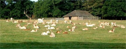
- (Start) From the car park walk into the village and turn left at the picturesque cobbled square. Go past the castle into Hollybank Lane following the Nidderdale Way. At a bridge over Ripley Beck you have a good view across the lake to the Castle. The track follows the park wall and from on a bank and at gateways you may catch a glimpse of the herd of dear in the park. At the corner of the park wall, where a notice proclaims here as a site of a former Manor, continue straight on to pass through Hollybank Wood. Go through a gate and on along a country lane to a road junction at Clint. Directly opposite, a footpath crosses a wall stile and heads down the side of fields into the Nidd valley. At the bottom you must rejoin the road, cross the River Nidd and reach the village of Hampsthwaite, by the church.
- (3.3km, 2Ľ miles) You can either, turn right through the churchyard or walk up to the village green and turn right along the road. The route via the churchyard does avoid some of the walk along the road, which is quite busy and has no footpath. About ˝mile from Hampsthwaite by a barn, a footpath sign indicates the way across a field to the riverbank. The path, at times segregated by a fence, follows the river towards Birstwith. As you near the village, with its large mill, turn sharp right as indicated to detour round the perimeter of the works to emerge on the main road by the old millstream.
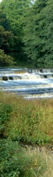
- (5.2km, 3˝ miles) Here you leave the Nidderdale Way for a while, turning right to re-cross the river. Looking upstream from the bridge you can see a large weir. Immediately take a footpath on the left into riverside meadows, and you soon come to where you are able to view the weir side-on. Continue alongside the river until you reach a 'permissive path' sign. This directs you up the side of a field, over a low embankment (the long-gone Nidd Valley railway line) to a lane leading to Nidd House Farm. (The actually right of way - somewhat overgrown - is up the other side of the hedge into the grounds of the farm). Walk past the buildings to join a bridleway, which follows the edge of woodland up to a wall corner where a sign shows the bridleway going left. Ignore this and go through the gate ahead into walled green lane. This climbs steadily out of the valley to a T-junction with the B6165 Pateley Bridge road.
- (8km, 5miles) With care, cross straight over to proceed along the bridleway opposite. Once clear of woodland you catch a glimpse of the rock formations of Brimham Rocks on the skyline to your left. At the next road turn right for about 300yds and then left at a footpath sign, just before Winsley Hall. Keep along the field side, passing the end of a belt of woodland. Now, just when a footpath sign is really essential, there isn't one! You must turn 90o left at a wall corner and walk along the right-hand side of this wall. At the next wall turn right and follow this downhill - it can be wet, because a stream follows a similar course! Continue downhill, through bridle gates, to reach a junction with the Nidderdale Way (no obvious sign). Turn right along the top edge of two fields then left down a field side, and finally right, past Cowgate Farm and along a lane into Shaw Mills. The Mills here are being redeveloped as quality homes.
- (10.5km, 7 miles) In Shaw Mills turn left up the hill through the village (a visit to the pub will involve a short detour the other way). At the end of the village, where the road turns sharp left, leave the road and take to a footpath straight ahead alongside gardens, crossing three stiles in quick succession, into a field. Walk across the field to a gate, go through and, still following the Nidderdale Way, turn left and climb diagonally up the field to a stone wall. Turn right and walk, with the wall on your left, down towards marshy ground. The track then bears left and climbs quite steeply up towards High Kettle Spring farm. Turn right and follow the track down through another gate to Low Kettle Spring farm. Pass the farm buildings and follow the farm lane for about ˝ mile to its junction with a main road.
- (12.5km, 8˝ miles) Turn left and walk up hill on this quite busy road for about ˝ mile, rounding a bend at the top to find a Nidderdale Way sign by the corner of a wood. Turn right to follow the Way along the lane beside the wood. The track enters a wooded dale and descends to cross Cayton Beck. This is a quite delightful setting, with the secluded, marshy, valley enclosed by wooded hillsides. Walk towards a gate and turn right to follow the waymarked bridleway down Cayton Gill. Pass a small wood, go through a gate and walk down the field to cross the beck. Go left to a gate into woodland and climb up through the woodland, passing a seat at the top, following the Nidderdale Way into Braithwaite Lane.
- (14km, 9˝ miles) Walk down the lane past Braithwaite Farm to the B6165 on the edge of Ripley. Cross diagonally over to follow what was once the main road through the village before the coming of the by-pass. Continue through the village back to the car park.
(16.5km/ 11 miles)
Along the Way
Do not depart however without exploring the delights of the village, its antique shops, cafés, etc or of, course the Castle if time permits. The old stocks still stand in the cobbled market square.
Ripley Castle has been the home of the Ingilby family for 650 years. It is open to the public on Sundays and Bank Holidays through the summer.
Arnold Underwood (Oct 2003/April 2004)
|