
|
North York Moors - Tabular Hills
'Rievaulx & Caydale'
From the popular tourist attraction of the majestic Rievaulx Abbey we head north through Cold Kirby into the remote Caydale. The return leg is through woodland and alongside the River Rye.
Fact File
|
Distance
|
15km (9˝ miles)
|
|
Time
|
4˝ hours
|
|
Map
|
OS Explorer OL26 North York Moors West
|
|
Start/Parking
|
Rievaulx Abbey (pay & display April – October)
|
|
Terrain
|
Field & woodland paths, farm tracks & minor roads
|
|
nearest Town
|
Helmsley
|
|
Refreshments
|
Tea-room at Rievaulx Abbey (restricted opening in winter)
|
|
Toilets |
none
|
|
Public Transport
|
Bus 198 (Tues & Thurs only) from Helmsley. Also Moorsbus in summer months (Sun & Bank Hols, May-Oct; Daily, July-Aug)
|
|
Suitable for
|
all (with dogs on leads through farmland)
|
|
Stiles
|
5
|

Route created using TrackLogs Digital Mapping
Image reproduced with kind permission of Ordnance Survey and Ordnance Survey of Northern Ireland.

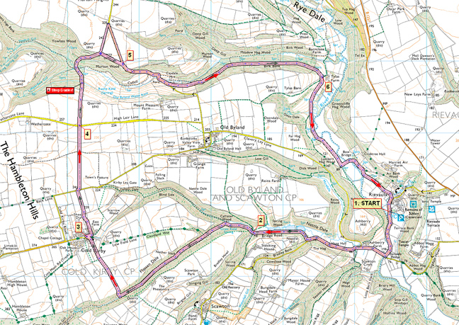
- (Start) From the Abbey car park, walk along the road away from the village to the T-junction by Rievaulx Bridge. Turn right over the bridge and continue along the road, straight on at the next junction, with the white-washed Ashberry Farm over to your right. Eventually you leave the road where it bears left and go through a gate onto a track (SP Cleveland Way). This takes you past a series of ponds thought to have been originally fish ponds for the Abbey.
- (2.4km/1˝ miles) At a junction of paths and tracks, finding the correct path can be confusing – we found it so. Do not go through the gate on the main track, but go right across a stream and a stile to follow a footpath along the bottom of the dale, still on the Cleveland Way. At the next junction take the left fork into Flassen Dale. A short distance further the Cleveland Way branches right and heads directly for Cold Kirby. However our route is less direct and continues up Flassen Dale with its steep wooded slopes. In about 1km a path from Scawton crosses the dale and it this we join as it climbs up the right-hand side of the dale. At the top emerge from the trees into open farmland and walk down the side of two fields leading to a track into Cold Kirby by the church. This section of the walk gives wide views north across the moors with the whaleback Easterside Hill prominent at the entrance to Bilsdale, along with the transmitter mast further north.
- (6.4km/4 miles) At the triangular green in Cold Kirby go right then turn at a bridleway sign up the gravel drive of house and through two gates between gardens. Note the cottage on the left is inhabited by ‘two old crows’. In the next field, a pile of logs make useful seats should you want to take a break. Go down the dip and through a gate and up the side of the next field to reach the Old Byland Road. Cross to the gate almost opposite and continue north along the bridleway by the side of a dry-stone wall in the process of being rebuilt (Feb – Oct 2008).
- (8.0km/5 miles) At the next road, once again cross and continue north on the bridleway. After topping a rise the wooded valley of Caydale comes into view. As the land starts to slope down, head for a bridle gate in the right-hand corner of the field. From this gate the path now picks its way steeply down through bushes into the valley, passing a seat and a signpost (Murton). At the bottom the path bridges a stream, passes through a gate, crosses another stream and begins the climb out of the valley. At another gate join a farm track and bear right (SP Bridleway). Keep left climbing gradually and follow the bridleway signs which divert you away from the main track for some reason, only to rejoin it further on up the hillside. At the top you leave the wooded slopes and again reach a plateau of open farmland. Here we can take a short-cut. On the right a track runs along the top of the valley side at the bottom of the field. This is not a right-of-way and a large tree trunk seems to have been placed to deter vehicles from cutting through. You suddenly come to a narrow tarmac lane that takes you down to Caydale Mill. (This short-cut saves you about 500m compared to following the bridleway further towards Murton and then back down the road)
- (10.8km/6ľ miles)Walk down this narrow lane back into Caydale. Looking ahead, it appears that the lane turns right straight into Caydale Beck – it does! For about 50m road and stream follow the same course – creating a rather long ford! This beck is by now quite substantial, draining as it does several square km of the Hambleton Hills so the ford does deter most through traffic. On foot walk alongside the ford to the access bridge to Caydale Mill and rejoin the tarmac.
A little way up the hill a bridleway sign by a gate indicates where we branch off left along the hillside. This area is pretty squelchy underfoot. Pass above the former Caydale Mill following the signpost to maintain height along the hillside to enter woodland. For about 1.5km the path contours along the wooded side of the dale. The woodland is initially mostly deciduous but towards the end becomes coniferous – dense and dark. You fall out into daylight onto a farm road by Tylas Farm in Ryedale.
- (10.8km/6ľ miles) Head south along this road and, in about 500m, bear left to take a footpath that crosses rough grassland to come alongside the River Rye. A section of the path near the river has been made into a boardwalk, which does make for easier walking, although it can be slippery when wet and covered by fallen leaves. It might be worth taking a quiet break here and hope to spot a kingfisher darting along the river. At the end of the wooded section the boardwalk ends abruptly and you come to a stile into more open land. Again, this low-lying, rough tussocky grassland can be very wet underfoot. Pick the best route across to a gate to rejoin the farm road near Bow Bridge. Turn left and cross the bridge and in about 200m go through a gate (SP Rievaulx) and head across hummocky ground (probably as a result of quarrying many centuries ago) into the next field. Keep along the top edge of this field, heading towards Rievaulx village and the Abbey. Note an indistinct channel just over the fence – this is the remains of an ancient canal thought to have been built to move stone from the quarry for construction of the abbey. Go through more gates to walk past a stable block and join the road through the village. Turn right back to the Abbey car park.(12.8km/8 miles)

Along the Way
Rievaulx Abbey is in the care of English Heritage. Go to
English Heritage - Rievaulx Abbey for more information
The Abbey was founded by St Bernard of Clairvaux in 1132 and became one of England’s wealthiest monasteries before its dissolution by King Henry VIII in 1538.This enormous Cistercian house, numbering some 150 monks and 500 lay brethren at one time, was the nucleus from which several other northern abbeys were colonised.
Arnold Underwood (Feb 2008, with thanks to Bob, Mike, & Pam)
|
