

|
NORTH YORKSHIRE COAST - Ravenscar
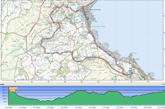
Ravenscar and Robin Hood's Bay - 17.6km (11 miles)
'Summer by the Sea'
This is a lengthy but rewarding walk with coastal & country scenery, and natural & industrial history.
To be sure of safely completing the section along the shore please check tide-times and if necessary switch the direction and/or the starting pont. Failing this, the cliff-top Cleveland Way can be followed between Stoupe Bank and RHB.
Fact File
|
Distance
|
17.6km (11 miles)
|
|
Time
|
5 hours
|
|
Map
|
OS Explorer OL27 (North York Moors East)
|
|
Start/Parking
|
Ravenscar (Grid Ref: NZ 980 015)
|
|
Terrain
|
Undulating - Suitable for keen walkers
|
|
Grading
|
****
|
|
nearest Town
|
Scarborough
|
|
Refreshments
|
Tearooms at Ravenscar (Station Square) and Robin Hood's Bay
|
|
Toilets |
Ravenscar and Robin Hood's Bay
|
|
Public Transport
|
Scarborough & District 115 to Ravenscar
|
|
Stiles
|
4
|

Route created using TrackLogs Digital Mapping
Image reproduced with kind permission of Ordnance Survey and Ordnance Survey of Northern Ireland.

- (Start) In Ravenscar, set off down the track by the NT Information Centre. Bear right down at a junction of paths to follow the Cleveland Way. After passing the old Alum works the path keeps along the side of fields to reach the cliff top. Here there is a good view back to the Raven Hall Hotel high on the cliffs. The path joins a lane by Stoup Bank Farm. Turn right and head down Stoupe Bank to the shore. If the tide is in, or coming in, you must use the cliff path (Cleveland Way) up the steps and over to Boggle Hole, and up and over again to Robin Hoods Bay. If the tide is out walk down to the beach and have a pleasant stroll along the beach to Robin Hood's Bay, but beware of the crumbling cliffs. You will have to negotiate Mill Beck as it spills across the beach at Boggle Hole, having flowed down from Ramsdale.
- (5.7km/3˝miles) In Robin Hoods Bay, walk up the steep narrow street. At the top a few seats provide a convenient spot for a break overlooking the bay. Continue onwards and upwards to reach the main car park on the site of the former railway station. Walk through the car park, passing the old station building, and turn right up Thorpe Road. Where the road turns left, go up steps (footpath sign) in the corner to a stile leading into a field. Walk up the edge of a series of narrow fields, crossing about 8 stiles in the process! At the top you arrive on Church Lane, where you turn left and then, in about 50m (50yds) turn right up a farm track. This narrows to become a sunken green lane, which can be wet underfoot. When this lane swings right another lane merges from the left. Double back up this track under some large trees. In places along this track ancient flagstones are evident. Between the trees the view across the Bay opens out after which you come upon a gate leading into a garden with a well manicured lawn. The path skirts round the perimeter of the garden before joining the driveway near the house to reach the road
- (7.2km/4˝miles) Turn right up the road (steep hill) through Raw. At the top, about 50m (50yds) past a turn on the right, a footpath sign points the way, left, along a track. There now follows an airy walk along the fringe of the moor between a mix of gorse and bracken. Evidence of former quarrying pock-marks the landscape on your right, but to compensate there is the complete panorama of Robin Hoods Bay on your left. Ignore other tracks to left or right and follow the contour round the hillside. After crossing the track to Skerry Hall, the way ahead becomes more overgrown, put press on and things improve as the track curves round to meet a road.
- (8.8km/5˝miles) This road is the main access to Robin Hood's Bay from the south, and can be quite busy. Crossing to face oncoming traffic, walk downhill for about 100m (100yds) and take the right fork towards Fyling Hall. Continue along this lane through the gateway (Fyling Hall School) and at the fork by the school, take to stony track on the right (bridleway sign). This track contours round the hillside, before dropping down into the wooded Ramsdale. The track twists and turns, with the beck down to your left, to arrive at the restored Ramsdale Mill. If you are lucky the restored water wheel may be operating. .
- (11.2km/7miles) Cross the bridge behind the Mill and walk up towards Mill Farm. There turn sharp right through a gate. Follow the field side (can be wet) up and round into Carr Wood. At the top of the wood turn left (bridleway sign) into open fields. Turn right through a gate then left to continue due east by a crumbling wall and gorse bushes. In the next field, swing right to follow the tractor track down and round to Swallow Head Farm. Go through the farm and down the lane to reach a minor road. Turn right and follow the road round the corner to where it was once crossed by the railway line.
- (13.6km/8˝miles) Join the old track bed on the right and follow it towards Ravenscar. Initially the route passes through woodland and under a couple of bridges. Then Stoupe Brow rises on your right above Browside Farm, whilst on the left the land falls away and there is an uninterrupted view of the full extent of Robin Hood's Bay. The track passes under the road down to Stoupe Bank and swings round towards Ravenscar. There is much evidence of former industry – alum mines and brick works – before branching off the old railway to rejoin the path up to the road in Ravenscar
Along the Way
Ravenscar – the resort that never was.
Long before being given the name ‘Ravenscar’ the cliffs near the ‘Peak’ were associated with a major chemical industry involving the extraction and processing of alum for use with dying of cloth. The site of the old Peak Alum Works can be explored.
With the coming of the railway, developers bought the land around the Peak and produced grand plans to create a cliff-top resort to be known as Ravenscar. Streets were laid out and plots were offered for sale for homes, hotels, etc. Alas the enterprise failed and only a few plots were sold. Today many of the streets of this resort that never was can be traced on the ground
Robin Hood's Bay is one of the prettiest fishing villages on the Yorkshire Coast. Its red pantile roofed houses cling to the cliffs around the ravine of Kings Beck. A very steep road links the old village, once the haunt of smugglers, with the more modern development at the top - which grew with the coming of the railway in 1885. Alas the railway is no more, but provides an excellent recreational path, and tourists have replaced smugglers as the main source of trade for the village.
The walk passes Boggle Hole - A Boggle is a hobgoblin - they were thought to live in caves along the coast.

Adapted from a walk by Arnold Underwood and friends (April 2010)
|
