

|
EAST YORKSHIRE - Millington
'Millington Dale'
This is an undulating stroll from one of the most delightful villages in the heart of the Yorkshire Wolds.
Fact File
|
Distance
|
12.8km (8 miles)
|
|
Time
|
3½ hours
|
|
Map
|
OS Explorer 294 (Market Weighton & Yorkshire Wolds Central)
|
|
Start/Parking
|
On grass verge opposite Millington church
|
|
Terrain
|
Undulating field paths and bridleways - several steep, but short, ups & downs
|
|
nearest Town
|
Pocklington
|
|
Refreshments
|
Ramblers Tea-room and The Gait Inn at Millington
World Peace Cafe at Kilnwick Percy Hall (see below)
|
|
Toilets |
none
|
|
Public Transport
|
none convenient.
|
|
Suitable for
|
all (with dogs on leads through farmland)
|
|
Stiles
|
None - now all replaced by gates I believe. The Yorkshire Wolds Way is entirely 'stile-free'
|

Route created using TrackLogs Digital Mapping
Image reproduced with kind permission of Ordnance Survey and Ordnance Survey of Northern Ireland.

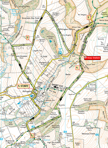
- (Start) From the church walk towards the cross roads and turn left up the lane. At the T-junction at the top cross straight over to follow the farm road down to Little Givendale Farm. Go past the farm along the track to a gate overlooking Whitekeld Dale. However our route this time takes us right (FP sign) away fro the dale, up the side of a large field back to the road.
- (2.4km/1.5 miles) Turn left up the road, continuing for about a mile as far as the driveway to Millington Heights farm. Turn right here and continue down past the farm to a gate opening onto the grazing expanse of Millington Pasture, at the time of writing populated by a herd of Highland cattle. These animals look intimidating but are quite docile, but like all cattle the cows can be very 'protective'of their calves! Continue down the side of the pasture by the left-hand fence (on the line of a Roman Road), to dip down to a gate into a gully. This brings you steeply down to the road through Millington Dale. Turn left along this road for a pleasant stroll along the dale, passing several wooden posts with carved letters that spell out 'IN WOLD' (There are four more near Millington Wood which spell out the missing word - 'GAIT').These posts are part of a 'Waymarker Sculpture Project' along the Dale.
- (6.4km/4 miles) In about half a mile, after rounding a bend, footpath signs indicate where we leave the road. Doubling back right up the hillside, the sign indicates the footpath up the other side of a fence, but with new access rights we can now walk up the track to a new gate at the top. Go through this gate and follow the path along the top overlooking Millington Dale. You are now following the Wolds Way. Soon you come to a seat overlooking the Dale, a place to take a break, although it may be more sheltered in Sylvan Dale, a little further on. It was a very steep descent into Sylvan Dale, but the gradient has been eased by zig-zagging the path.However it needs to be taken carefully. You are then faced with a not-quite-so-steep climb up the other side diagonally to a stile.
- (8.0km/5 miles) Bear left to follow the Wolds Way up the side of the field to a corner and their strike off right across the hillside to arrive at the track leading to Warren Farm. Bear right then left keep along the field edge above Warren Farm. In a short distance a path, right (The Minster Way), provides a short cut down to Millington. Otherwise continue on the Wolds Way along the top, with panoramic views over Millington and on across towards York. Approaching North Plantation the path does a left-right zig-zag and joins a tractor track down the side of Warrendale Plantation to a junction with a minor road near Kilnwick Percy.
- (10.8km/6.5 miles) Here we leave the Wolds Way and turn right to walk down this road into Millington. At the bottom of the hill the road turns and crosses Millington Beck and climbs up to the village. Turn right into the village and The Gait Inn is on your left, the Ramblers Rest tea-room on the right. Just beyond these turn left back up to the church and your car. Time permitting have a look round this quaint little church. (12.8km/8 miles)

Along the Way
The Gait Inn at Millington gets its name from the days when the vaste open sheepwalks were enclosed. Millington Pasture was shared between the local people, with each share being a 'gait' - enough grazing for six sheep.
About 15 years ago the spelling of the pub name was changed from 'Gate' to the correct 'Olde English' form - Gait.
There is archeological evidence of a Roman settlement in Millington Dale, taking advantage of the springs, and OS maps show the alignment of a Roman Road cutting across the Dale.
Drop in to Madhyamaka Centre's World Peace Cafe at Kilnwick Percy Hall and try our delicious vegeterian meals and yummy cakes. There are acres of woodland and parkland to explore after your visit to the cafe.

Opening times: usually every day 11.00am - 4.00pm (Closed over Christmas and New Year)
If you would like to visit the cafe with a group of 6 or more people, please ring or email in advance to ensure we can fit you in and feed you!
Email worldpeacecafe@gmail.com
For full information and menu visit the website at
www.madhyamaka.org/world-peace-cafe
Arnold Underwood (Nov 2007, updated April 2023)
|
