|
WEST YORKSHIRE - Marsden Moor Circular
'Magical History Tour'
A superb walk from this former mill town at the head of the Colne Valley. The route follows the Wessenden valley past reservoirs up on to Marsden Moor and Standedge. On the return, visit the new attractions of the restored Huddersfield Narrow Canal at Tunnel End and even take a trip by barge back to Marsden.
Fact File
|
Distance
|
16km (10 miles)
|
|
Time
|
5 hours (but allow more)
|
|
Map
|
OS Explorer OL 21 South Pennines & OL1 Dark Peak
|
|
Start/Parking
|
Marsden Railway Station - new car-park grid ref:SE048 118
|
|
Terrain
|
Varies from canal towpath to bleak moorland with over 800ft ascent/descent.
|
|
nearest Town
|
Huddersfield
|
|
Refreshments
|
Pubs and shops in Marsden and at Tunnel End. Pubs on A62 near Redbrook Reservoir.
|
|
Toilets |
At Tunnel End
|
|
Public Transport
|
Local trains on Leeds to Manchester line. Frequent buses from Huddersfield to Marsden. |
|
Suitable for
|
for experienced walkers. Be prepared for extremes of weather! |
|
Stiles
|
4
|
- (Start) Head down station road, bearing right to pass St Bartholomew's Church. Go through the tunnel under the A62 and up past a sports field to a roundabout. Go straight across and take the first right at a footpath sign. The track passes between the walls of a large mill and emerges at the foot of Butterley Reservoir dam. There are 210 steps to the left of the dam which brings up to the level of the water company road up the Wessenden Valley.
- (2km, 1˝ miles) There now follows a pleasant stroll up this road past Butterley and Blakey Reservoirs. Beyond Blakey Reservoir you come upon a Pennine Way sign. Turn right here off the road and descend steeply to cross Wessenden Brook by a footbridge. The scramble up the other side is even steeper, but at the top the concrete edge of a covered water tank makes an ideal seat from which to survey the scene back towards Marsden.
- (5km, 3Ľ miles) Breath regained, follow the path alongside Blakey Clough to a weir and cross to the opposite bank. The path climbs up onto open moor, and, being the Pennine Way, is now paved with flagstones to reduce erosion of the moorland. Route-finding is therefore not the problem it was 10 years ago. Follow the clearly defined path which passes Swellands and Black Moss Reservoirs. Beyond a slight rise the larger Redbrook Reservoir comes into view with Pule Hill beyond.
- (6.3km, 4Ľ miles) The path joins another track coming up from Marsden - a very early pack-horse road. From up here there is evidence of many of the routes across Standedge - pack-horse, turnpike, and present day roads plus the air shafts and spoil tips along the line of the tunnels. Follow the track as it swings away from the reservoir to come to the A62 at Standedge cutting. Here there is a small car-park, and information boards.
- (8.5km, 5Ľ miles) Cross the main road and follow the Pennine Way north-west along the Millstone Edge with fine views west towards Oldham and Manchester. Near the trigpoint see if you can find the Ammon Wrigley stone - dedicated to a local poet. At Northern Rocher the path crosses a gulley and a guide stone marks a fork in the path - bear right, still on the Pennine Way. Again the Way is surfaced across Oldgate Moss and down into Oldgate Nick. With the A640 road about 200yds ahead, look out for a faint short-cut path heading right across Little Moss to a marker post on the old pack-horse road down to Marsden. (If you miss it, just continue to the A640 and double back).
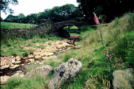
- (12km, 7Ľ miles) There now follows a long undulating descent towards Marsden. The path is clear to follow but uneven and boggy in places. Views down the Colne Valley open out as you proceed. Eventually the path descends steeply to a stream, which is followed down to a delightful setting where streams converge to form the River Colne. A packhorse bridge (Close Gate or Eastergate Bridge) forms the centrepiece of this scene - which featured in several episodes of 'Last of the summer Wine'.
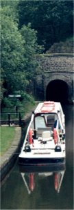
- (14km, 8ľ miles) Cross the bridge and follow the path along the river bank to a gate onto a lane. Walk down the lane towards Marsden. At the Tunnel End Inn turn right and walk down to the restored Huddersfield Narrow Canal. If time permits explore the area around this the eastern end of Standedge Canal Tunnel. Note also the railway tunnel at a slightly higher level. It may well be possible to travel by barge, the Marsden Shuttle, back to the car park. Otherwise cross the canal by the footbridge to join the towpath. This passes under the railway lines to bring you back to the lock-gates by the railway station and car-park.
Along the Way
Marsden - once a run-down mill town has now got so much going for it following the superb restoration of the Huddersfield Narrow Canal. A large new car-park has been created near the railway station to cater for the new tourist traffic. The Marsden Shuttle barge links the station and car-park with the main attractions at Tunnel End. Here there is a museum in a former warehouse and electrically powered glass-roofed barges take visitors into Standedge Tunnel. All this is surrounded by over 5,000 acres of Marsden Moor, which since 1955 has been in the care of the National Trust. This moorland has always been an obstacle to trade between Yorkshire and Lancashire and over the centuries a variety of routes have been followed - evidence of which remain to this day. Various locations in and around Marsden have been used in episodes of 'Last of the Summer Wine'.
Arnold Underwood (Aug 2002/Feb 2003)
|