|
DERBYSHIRE - Return to the Edge
Longshaw to Stanage by way of Hathersage
All the best features of the Dark Peak – woodland, riverside, gritstone crags and moorland - in one classic walk! Down the wooded Padley Gorge to the River Derwent followed by a long climb up on to Stanage Edge. Here wide-ranging views abound as the gritstone edge is followed by way of Higger Tor and Carl Wark back to Longshaw Park.
Fact File
|
Distance
|
16km/10 miles
|
|
Time
|
5 hours
|
|
Maps
|
OS Explorer OL1, Peak District (Dark Peak) and OL24, Peak District (White Peak)
|
|
Start/Parking
|
Car park at Longshaw Lodge (NT) Grid Ref: SK 266800 (entrance on B6055 near Fox House Inn)
|
|
Terrain
|
Field & moorland, woodland & riverside paths & tracks
|
Grade
|
***** strenuous
|
|
nearest Town
|
Sheffield
|
|
Refreshments
|
Pubs, cafes, and shops in Hathersage, Tea room at Longshaw Lodge
|
|
Toilets |
Longshaw, Hathersage, and near the car park above North Lees House.
|
|
Public Transport
|
‘Peak Bus’ Sheffield – Hathersage – Castleton, plus other services from the surrounding area.
Local Manchester – Sheffield trains (various operators) stop at Grindleford (for Padley) and Hathersage stations.
|
|
Suitable for
|
strong walkers
|
|
Stiles
|
8
|
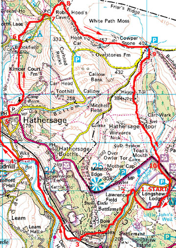
Image produced from the Ordnance Survey Get-a-map service.
Image reproduced with kind permission of Ordnance Survey and Ordnance Survey of Northern Ireland.

- (Start using White Peak map) Leave the car park, and head down towards the Lodge. Follow the gravel footpath by the fence below the lodge. Open views to the right reveal the flat-topped Carl Wark and Higger Tor – to be visited on the return to Longshaw. The path enters the fringe of Granby Wood, passing a pond on your right. Walk down to the B6521 road. On fine weekends there is likely to be around Ľ mile of parked cars along the roadside. Cross to the right to find a wall stile behind the cars. Follow the well-worn path down to the footbridge across Burbage Brook. This area is very popular with picnickers.
- (0.8km/˝mile) Walk down stream to enter the wooded confines of Padley Gorge at a gate. The path picks its way down through the trees with the beck tumbling over its rocky course far below. Keep to the main path until you come to a stone building (a disguised water pumping station). Here take a lesser path to the right over a stile into woodland. This picks its way down the hillside, passing behind homes set in superb location with a stunning view down the Derwent Valley. Turn at a wall corner to follow the path down to a rough road next to a cattle grid. Just to the left, across the cattle grid is Padley Chapel and the ruins of the old manor – worthy of a visit (see Walk for Aug 2003 for details).
- (2.7km/1ľ miles) From the Chapel, cross back over the cattle grid and head down a track on the left – this crosses a bridge over the Sheffield/Manchester railway and enters the open meadows of the Derwent Valley. Ahead a footpath sign by a wall indicates the route to Leadmill Bridge. Cross a couple of fields swinging right towards a corner of woodland by a bridge over the railway. Do not cross the bridge but go through a gate on the left, into the wood. A rough path descends through the wood to emerge in riverside pasture. (Here you will need to switch to the Dark Peak map) Keep close to the River Derwent through two fields, then at the next field cut straight across to a footpath sign by a restored former farmhouse. Join the gravel driveway to this house and follow it for the ˝mile to the B6001 road at Leadmill Bridge
- (5.5km/3ľ miles) Cross the road to continue along the well-used footpath across the fields towards Hathersage. This path meets a minor road. Here turn left, passing the entrance to Nether Hall, and walk round to go under the railway bridge into the centre of Hathersage. With a choice of pubs, cafes, etc this make a good location for a break, but don’t eat and drink too much because the strenuous part of this walk is still to come!
- (6.5km/4˝miles) Walk up the main street and turn left along a lane that leads to the village cricket pitch. There are a few benches here, and it makes a pleasant spot for a picnic lunch if you so decide. By the cricket field turn right to followed an enclosed path up hill towards St Michael’s Church. Enter the churchyard and pay your respects at the grave of Little John, situated over to the right opposite the Church porch. Leave the churchyard by the lytch gate and turn left along the lane. Go into the field and follow the steps cut into the steep hillside down to a footbridge in the bottom corner. Continue up the side of the next field after which you should cut diagonally across up to the far corner. From that point you contour along the hillside to the right of a hedge straight to Cowclose farm. The path skirts to the right of the farm and then continues in the field parallel to and above the farm drive to reach a stile at a minor road opposite a campsite. (Note: the farm drive itself is not a right-of-way)
- (8.6km/5ľ miles) Turn left along the road, passing the farm drive gate, to reach the entrance to North Lees on the right. Go through the gate and walk up the tarmac drive to the castellated house, built by the Eyre family in the 16th century. An information board explains its connections with the Brontes. Behind the hall turn right up a walled track and then across an open hillside with Stanage Edge looming ahead. Maintain direction on a clear path, which enters woodland and climbs up to meet a road. (Toilets are situated near the car park about 100yds along to the left.)
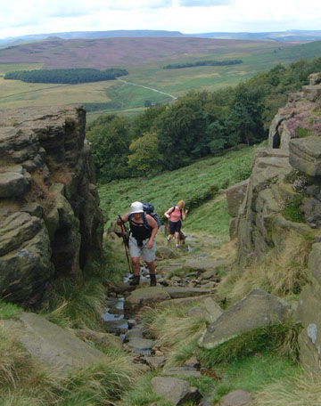
- (9.7km/6ľ miles) Directly ahead, the Edge looks threatening. It will no doubt be dotted with rock-climbers appearing the size of ants from here. You could opt out of the challenge, and follow the road, right, towards Upper Burbage Bridge, but it seems a pity having got so close. Various paths created by rock climbers lead up to the crags and one provides a direct route to the Edge up through the bracken, with the trees of Stanage plantation to your left. It’s a steady pull, but the path is clear enough and eventually you will find yourself among the tumble of rocks below the crags. Venturing round to the left you should find a clear track that must have been cut through the rocks in years past, and provides a surprisingly easy route up on to the top. Now take time to savour the view, particularly west across towards Hope and Edale, with the Great Ridge leading to Mam Tor, Rushup Edge, and Kinder Scout.
- (10.3km/7miles) Head south along the Edge. As well as the view, the activities of rock-climbers and paragliders provide further interest. At a trig point (457m) you reach the highest point on this walk, and if the day is clear you now also have wide ranging views to the east, with the power stations of the Ouse and Trent valleys in the distance. The path picks its way down through the rocks and heads across moorland towards Upper Burbage Bridge, another location which attracts visitors and easily spotted by the number of parked cars. However, this does mean there is usually an ice cream van there!
- (12.5km/8miles) Cross a stile in the fence and follow the well-worn path that contours round the hillside above Burbage Brook towards Higger Tor. Another steady pull brings you up onto this plateau. Continue due south across the top – now it is more difficult to find the way down the other side. Pick your way down through the rocks and you will find a clear path continuing across the hollow up to Carl Wark. Beyond Carl Wark the path descends across marshy ground. Longshaw Lodge can be seen directly ahead. Fork left off the main path and drop down to cross Burbage Brook. At the top of the bank join a track, which leads to a gate and the A6187 road.
- (15.2m/9˝ miles) Cross with care to a bus stop, to enter woodland by a stile. Walk up through the woods, parallel to the main road to arrive at the B6521 road opposite the entrance to Longshaw Park. Go through the gate and walk along the drive towards the Lodge. A path swings left up to the car park, but you may well want to make use of the facilities (tea and toilets) before returning to your car. (16km/10miles)
Along the Way
Padley Chapel – this is all that remains of the 14th century manor house of the Padley family. In 1588, during the period of persecution of Catholics, two priests Nicholas Garlick and Robert Ludlam, had taken refuge there. They were discovered and arrested and hanged a few days later. In 1933 the Catholic Nottingham Diocese purchased the site and converted the one remaining building into the chapel we see today.
North Lees Hall – built in the 16th century for the Eyre family. The Hall features in the novel, Jayne Eyre, written by Charlotte Bronte after visiting the area in 1845.
Longshaw Lodge – a former shooting lodge for the Duke of Rutland, now owned by the National Trust
Arnold Underwood & LWC (August 2004)
|