|
EAST YORKSHIRE - Market Weighton
As featured in Country Walking Magazine, June 1999
'Londesborough Park'
A pleasant walk following part of the Wolds Way on the edge of the Yorkshire Wolds. Interesting features include an attractive estate village & parkland, a 'lost' village, a nature reserve and a section of disused railway.
Fact File
|
Distance
|
12km (7Ĺ miles)
|
|
Time
|
3Ĺ hours
|
|
Map
|
OS Landranger106 or Explorer 294
|
|
Start/Parking
|
Market Weighton (Londesborough Road)
|
|
Terrain
|
Undulating field paths and bridleways and disused railway
|
|
nearest Town
|
Market Weighton
|
|
Refreshments
|
Pubs at Goodmanham and Market Weighton
|
|
Toilets |
at Start/Finish
|
|
Public Transport
|
East Yorkshire service X46 (Hull - Market Weighton - York)
|
|
Suitable for
|
all (with dogs on leads through Londesborough park)
|
|
Stiles
|
2
|
- (Start) From near the toilets in Market Weighton cut through the market place, turn right along the pavement and head out of town towards York. You pass an old chapel, and some newer housing before coming to a Wolds Way sign pointing to Londesborough. Follow this path along field sides, crossing footbridges, to reach the busy A614 Bridlington road.
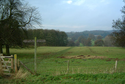
- (2km, 1ľ miles) Cross the road with care to continue along the driveway opposite. Walk past the buildings at Towthorpe Grange and enter a field. Continue across the field and through the opposite gate. This is the site of the lost village of Towthorpe, revealed by the humps in the field. There is free access in this area as shown by Countryside Commission notices. The path curves right to another gate and stile - cross and continue along the field side with Towthorpe Beck on your right. At a road turn left and in about 50m (50yds) you reach the entrance to Londesborough Park.
- (3.25km, 2 miles) You could go through the gate (Wolds Way sign), probably disturbing the geese and dogs (in kennels) at the gatehouse. Have no fear, continue along the driveway through the park with a lake down to your right. In about 400m (ľ mile) you come to another Wolds Way sign indicating the route to Goodmanham.
Alternatively, to visit the village continue up the road past the park gates, for about Ĺ mile, to a footpath sign by a gate on the right. The avenue of trees here once extended across the fields down to George Hudson's private railway station. Go through the gate and climb the bank to the left coming to a gate leading to an enclosed path. This takes you to the main street in Londesborough. Turn right, and follow the lane round a corner passing the church and an information board. The original Hall was behind the wall on your right. Continue ahead down a driveway - the present Hall is through the gate to the left - here bear right and walk down through the trees to another gate opening into the park. Follow the track through the park to the Wolds Way sign mentioned earlier.
- (4.75km, 3 miles) Follow the Wolds Way down across parkland to gates and a footbridge over the stream between two lakes. Continue up the hill-side on a faint track to a gate. Here there is a view back across the park to the Hall(see photo above). Turn right along the farm road which curves left over the hill - the summit of the walk at 80m (260ft) above sea level - and then turns sharp right. Here, continue straight along a rutted track by the side of a field to reach the A614 at Towthorpe Corner. Cross the road with care and discover, behind the trees, a picnic site with a few tables - a suitable spot for a break.
- (6.25km, 4 miles) From the picnic area, walk south along the Wolds Way, in about 400m (ľ mile), turning sharp left down the side of a field. Ignoring a path at a gap in the hedge, continue down a farm track, under an old railway-bridge and up into Goodmanham. The pub - the Goodmanham Arms - is round to the right, behind the church.
- (8 km, 5 miles) Follow the road east out of Goodmanham turning right at the first junction. This road descends into a dale alongside a disused railway at a location known as Springwells. This area is managed by the Yorkshire Wildlife Trust, assisted by local schools and other organisations. Where the road crosses the railway turn sharp right onto the track-bed (The Hudson Way) and follow it back along the embankment towards Market Weighton. In about 800m (Ĺ mile) you pass St. Helen's Well where crystal-clear water emerges from a spring below the chalk and flows down into the stream. Here you can leave the track-bed to follow a path alongside the stream. This path rejoins the track in about 200m (220yds).
- (11.5km, 7ľ miles) Where the track-bed expands at the site of the old railway yard, keep to the more obvious path to the left. Walk past some modern housing, built on the station site, into Londesborough Road. Turn left to arrive back at your car (12km, 7Ĺ miles).
Along the Way
The original Londesborough Hall was demolished early in the 19th Century, to be replaced by a new building some distance to the east of the original site. George Hudson, the 'Railway King', bought Londesborough estate in 1845 to prevent a rival company building the railway from York. Hudson then built the line, complete with his own private station. After the railway was closed in the 1960's, the section from Beverley to Market Weighton was converted to a footpath now called the 'Hudson Way'.
It is said that Goodmanham church was built on the site of a pagan temple, which was destroyed when King Edwin of Northumbria was converted to Christianity in 627AD.
Market Weighton is a quiet market town these days. It was once the junction of four railway lines (closed in the 1960's), and of five main roads (now by-passed). The town's main claim to fame is that it was the home of England's giant - 27stone, 7ft 9 inches tall William Bradley.
Arnold Underwood (Jan 2002/Revised Dec 2005)
|