|
NORTH YORKSHIRE - Round via Lastingham
'Tops and Dales'
A mix of woodland and riverside feature in this walk linking some delightful villages on the fringe of the North York Moors. From Sinnington there is a steady climb to the hill-top villages of Appleton-le-Moor and Spaunton. After descending to the atrtactive village of Lastingham the return route is in the company of the River Seven, which rises at the head of Rosedale and after passing through Sinnington joins the River Derwent in the Vale of Pickering.
Fact File
|
Distance
|
13km (8 miles)
|
|
Time
|
allow up to 5 hours
|
|
Map
|
OS Explorer OL North York Moors Eastern & Western Areas (this route unfortunately overlaps the two maps)
|
|
Start/Parking
|
Park tidily by the green in Sinnington (honesty box for donations)
|
|
Terrain
|
Woodland paths and bridleways and minor road
|
|
nearest Town
|
Pickering
|
|
Refreshments
|
Pubs in Sinnington, Appleton-le-Moors, and Lastingham
|
|
Toilets |
none
|
|
Public Transport
|
Scarborough & District 128 serves Sinnington
|
|
Suitable for
|
all
|
|
Stiles
|
-
|
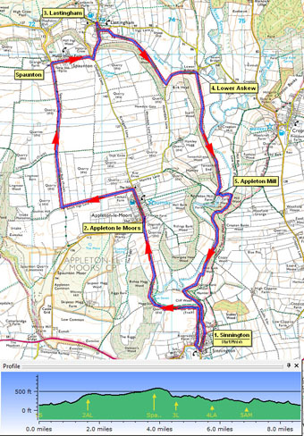

Route created using TrackLogs Digital Mapping
Image reproduced with kind permission of Ordnance Survey and Ordnance Survey of Northern Ireland.

- (Start) From Sinnington village green cross the road bridge over the River Seven and then immediately turn right along a bridleway track in front of cottages. This track initially keeps by the river. As you approach woodland go through a gate on the right marked 'to Appleton'. Now the path climbs away from the river. Leave the woodland and cross a field to a gate and turn left up the side of the next field. Go through more gates and past a farm to emerge in Appleton-le-Moors.
- (2.5km, 1˝ miles) Walk up the wide main street of the village - the Moors Inn is on the left. At the top of the village,just past Appleton Hall and opposite the church, turn left along a green lane (bridleway). In about ˝ mile, at a junction, turn right through a gate to follow another green lane straight over Spauton Moor (farmland). Continue straight on at the next junction and to arrive at the western end of the hill-top village of Spaunton. Turn right through the village and at the road junction cross slightly to the right to a footpath sign. Follow this path steeply down the wooded hillside into Lastingham village. To visit the Church or the Blacksmiths Arms continue forward and round the left-hand bend - the pub is conveniently opposite the Church. There are also one or two seats on the green by the stream for a picnic lunch.
- (4.75km, 4 miles)Walk back through Lastingham, round the bends, and on the right just past the last house, take the footpath on the right. This leads to across to a stile after which the path appears to coincide with a stream for a few yards! Cross another stream by an ancient stone slab bridge then head up through woodland to emerge into open pasture.round to a minor road. Turn left and walk down the road to Lower Askew.
- (5.5km, 3˝ miles)Just before the corner at Lower Askew take the footpath on the right (the right-hand of two gates). Walk along the field side and enter the wooded hillside. Follow the narrow path which picks its way through the trees along the side of the valley. Here, wild daffodils, garlic, primroses, and bluebells provide a succession of blooms through the spring. The path climbs high above the river then descends and leaves the woodland, but keeps to field side by the wood round to a gate near Appleton Mill.
- (8km, 5 miles) Do not go through the gate, but turn left to follow the edge of the field round to a substantial footbridge over the River Seven. Continue up to a sign at a junction of paths. Turn right (bridleway) through a gate and climb steadily up through the trees. At the top the path swings right to a junction of paths. Here, take to a narrow path almost straight ahead. This is a 'short cut' which drops steeply down the side of the valley to meet another track coming from the ford at Appleton Mill. This track keeps along the bottom of the valley until forced to climb by a loop of the river. At a fork keep to the right after which the path again descends to the valley bottom. Enter open farmland (recently ploughed) and walk along the left-hand side below the woodland. Go through a gateway and soon the river, have made another wide loop, comes alongside once more. Pass below the rock face of an old quarry and re-enter Sinnington. Passing between cootages to arrive back on the green.
Along the Way
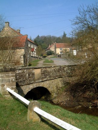
Sinnington is a picturesque village at an ancient crossing point of the River Seven. In springtime the daffodils on the green rival those of nearby Farndale. The woodland also abounds with spring flowers - daffodils, primroses, wild garlic and bluebells.
Appleton-le-Moors is a typical moorland village, with a single broad street bordered by stone built houses. The church was designed by Victorian architect J.L. Pearson, who was also responsible for Truro Cathedral.
Lastingham is an attractive village with an interesting Church built on the site of a monastry founded by St. Cedd over 1300 years ago. Later, a Norman crypt was built over the shrine of St.Cedd as part of an attempt to restore the monastery. Then, in the 14th century, the partly rebuilt abbey church became the parish church we see today in which the Norman crypt has remained, completely unaltered, since the time of William the Conquerer.
Arnold Underwood (March 2003)
|