|
NORTH YORKSHIRE - Kirkdale
'Down St Gregory's Way'
Explore the wooded valley of Kirkdale, with its historic church, and two hilltop villages on the southern flanks of the North York Moors - a walk for all seasons.
As featured in Country Walking magazine - Jan 2010
Fact File
|
Distance
|
12˝km (8 miles)
|
|
Time
|
4 hours
|
|
Map
|
OS Explorer OL26 North York Moors Western Areas
|
|
Start/Parking
|
Kirkbymoorside main street or car park
|
|
Terrain
|
Field & woodland paths and bridleways and minor roads
|
|
nearest Town
|
Kirkbymoorside
|
|
Refreshments
|
Pubs in Kirkbymoorside, Fadmoor, and Gillamoor
|
|
Toilets |
Kirkbymoorside
|
|
Public Transport
|
Scarborough & District 128 serves Kirkbymoorside; various Moorsbus services in summer.
|
|
Suitable for
|
all
|
|
Stiles
|
8
|
- (Start) Walk up the main street of Kirkbymoorside, turning left at the top into Dale End. Look out for footpath (Back Line) on the left leading behind house to a new estate. Follow a path left through the estate then bare right following the road round through bungalows. At the end go right to find a footpath between nos. 45 and 47. This leads to a stile into fields - the tricky bit is now over!
- (1km, ľ mile) Head straight across three fields from stile to stile, then pick up a tractor track through gateways, veering south, away from Snapes Wood to keep to the bottom edge fields as far as Hulyer Bank. Cross a stile and bear left to follow a path along the bank to a gate opening on to a minor road. Go straight across and follow the road to Kirkdale. Note across the field to the left a viaduct on the long gone Scarborough to Helmsley railway line. As the road dips to ford Hodge Beck, take a few minutes to explore Kirkdale Cave among the trees on the right.
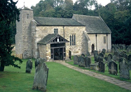
- (3km, 1ľ miles) Cross Hodge Beck, by the footbridge if necessary, and turn right down the lane to the little church in Kirkdale - St Gregory's Minster. This dates from Saxon times and is worth a visit if possible. Continue past the church through a gate and take the right fork crossing rough ground towards a flag pole. Here you must once again cross Hodge Beck, and again there is a footbridge, but rarely is there water in the beck here as it tends to disappear underground further upstream. Continue along a faint path into woodland, merging with another path.
- (5km, 3 miles) At a junction take the left fork, keeping along the bottom edge of the wooded valley with the beck to your left. After a gate the path, now a stony track, starts to climb steadily over Cat Scar - from where you get a good view across the dale. A gradual descent follows to the weir and former mill at Hold Caldron - there is plenty of water in the beck here. Leave the track and go through the gate into a field as indicated. Continue across to come close to the wooded slopes and look out for a gate on the right way-marked with a yellow arrow. Go through the gate and continue once more within the wooded slopes of the dale. Immediately after another gate take the right fork and climb steadily up the valley side through Mell Bank Wood.
- (7km, 4˝ miles) Continue onward as indicated by a bridleway sign to eventually join a track at the top. Go left, following the 'Link' sign. Soon you come to a minor road and turn right (SP Link - Fadmoor 1 mile). For ˝ mile this quiet lane is a tree-lined avenue. Turn left into Fadmoor, where the first building is the Plough Inn - how convenient. If it's not yet opening time continue right past the village green and follow the roadside footpath to Gillamoor, less than a mile from Fadmoor. On the green there is the Royal Oak Inn. Walk on down the main street, noting on the left the unusual sundial, towards St. Aiden's Church. Just past the church on the roadside is a 'surprise view' across Farndale to Blakey Rigg and the moors north of Hutton-le-Hole.
- (8.5km, 5˝ miles) Back at the church, take to a narrow path heading SE away from the church. Continue straight on up a bank across rough ground to a junction of paths. Cross the stile in front and walk along an enclosed path by the side of a paddock with horses. Go through a gate and continue forward from stile to stile straight across three fields, then along field sides to a stile onto a farm track. Turn right along this track to its junction with Woodhead Field Lane. Turn left along this lane passing Cockpit Hall to arrive, in a further ˝ mile at a junction near High Park Farm.
- (10km, 6˝ miles) Turn right and, then opposite the farm, bear left through a metal gate. Keep to the path round the field sides passing a memorial seat, to come alongside a golf course. As the surroundings become wooded take the right fork down into a wooded valley to reach a metalled road leading to the club house. Turn left and walk down this road, passing through the council Highways Dept depot, back to Dale End, Kirkbymoorside. Turn left, then right to arrive back at the town centre.
Along the Way
Kirkdale Cave was discovered during quarrying in 1821. Inside were found bones of many animals, including those of over 500 hyenas, and Prof. Buckland of Oxford University said at the time that the discovery was proof of the biblical Noah's flood.
Five minutes from the cave, St. Gregory's Minster stands at the entrance of Kirkdale. This delightful little church dates from Saxon times, and was extensively rebuilt between 1055 & 1065 by Orm, Son of Gamiel - a fact commemorated on its Saxon sundial.
Arnold Underwood (Oct 2002)
|