|
EAST YORKSHIRE WOLDS - Huggate - 14.5km (9miles)
'Round from Huggate'
A pleasant walk on the Wolds at any time of year, by way of grassy dales and bridleways and farm roads from Huggate, the highest village on the Wolds. The route uses new open access through Horsedale to link existing rights of way
As featured in Country Walking magazine - Spring 2009
Fact File
|
Distance
|
14.5km (9˝miles)- can be shortened
|
|
Terrain
|
Field paths, tracks & minor roads
|
|
Time
|
4 hours
|
|
Stiles
|
5
|
|
Grading
|
*** easy/moderate
|
|
Suitable for
|
all
|
|
Start/Parking
|
Park tidily by the green or in Church Street in Huggate (Grid Ref: SE 881552), or at the Wolds Inn with permission |
|
Nearest Town
|
Pocklington
|
|
Refreshments
|
Wolds Inn, Huggate (01377 288217)
Rachel's Walnut Cottage Tea Room, Huggate (01377 288378)
|
|
Toilets |
none
|
|
Public Transport
|
limited shoppers service from Pocklington (Tuesdays only)
|
|
Map
|
OS Explorer 294
|
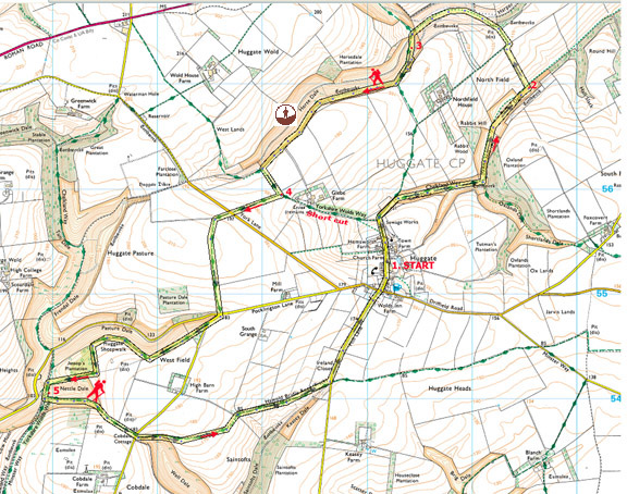

Route created using TrackLogs Digital Mapping
Image reproduced with kind permission of Ordnance Survey and Ordnance Survey of Northern Ireland.

- (Start) Set off down through the village, past the green and St Mary’s church, with its spire. Go down the lane passing the turn for Glebe Farm and look out for a stile on the right, by a new metal gate. Cross this stile and head down into Cow Dale. At a junction of dales cross a stile, and turn left - this takes you into Rabbit Dale. Ignore a track heading up right and cross a stile by a gate to continue along the dale bottom now with a fence on your right.
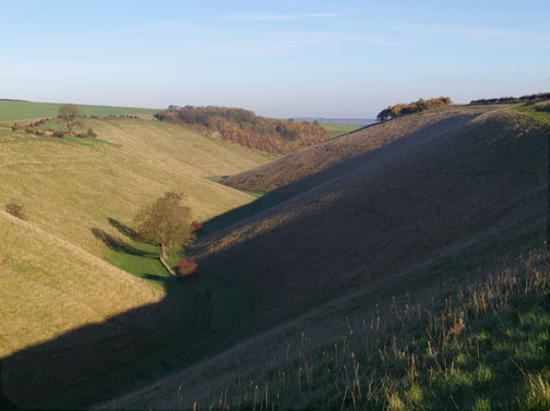
- (2.4km, 1˝ miles) At the next field boundary’ look out for a way-mark pointing left up the hillside, by the hedge. This path doesn’t appear on OS maps but has been in existence for at least 20 years. (It appears on the former Humberside County Council route cards). Walk up the field side with the hedge on your left to meet a farm track at the top and there turn right. The track soon turns sharp left and then swings down through Harper Dale to meet the Wolds Way again at the convergence of Holm Dale and Horse Dale. The latter is now open access and provides a link to the right-of-way at the western end of the dale.

- (4.8km, 3miles) Although ‘access land’, a wire fence restricts access to the north side of Horse Dale. In fact the best route through the dale is along the top of the southern slope. From the dale bottom you should follow the Wolds Way diagonally up the hillside, towards Huggate, but before reaching the top strike off to the right on a faint track, which contours along the daleside passing below a small plantation. There are good views along Horsedale from here. After about 1.5km (ľmile) you will encounter the bridleway from Wold House Farm. Turn left here, through a gate, and head once again towards Huggate. Walk along a field side to the driveway for Glebe Farm – from here it is less than a mile directly back to Huggate.
- (7.0km, 4Ľ miles) To continue the longer walk turn right (Wolds Way) along the farm drive to a junction with the road from Huggate. Go straight over, following a tractor track along the edge of a field, and then left at the next field boundary. Although clearly signed you could easily miss this and head straight along the track! On this next section you cross the highest point on this walk (210m above sea level) before dropping down to meet a minor road. Take the left fork (for Warter) and walk along this lane for about 200m. At a bend continue straight on, following the Wolds Way towards Millington. The path contours round the rim of Pasture Dale, with the lane to Millington running along the valley floor. After the scrubby woodland of Jessops Plantation the path plunges down into Nettle Dale. Nettle Dale is now open access, although we saw no indication of that from this direction. As the return route follows the Minster Way east out of Nettle Dale it may be possible to cut across the head of this dale from Jessops Plantation, avoiding this steep down and up.
- (11km, 6ľ miles) From the bottom of Nettle Dale head up the other side to where a Minster Way sign points the way alongside a hedge of hawthorn trees. The going is tough through long, tussocky grass and beneath overhanging branches. Eventually the path cuts away up to a gate at the corner of a wood at the head of the dale. It’s easier going now but still slightly uphill until you reach the Warter road again by Cobdale Cottage. Go straight over, following the Minster Way along the Hawold Bridle Road. There are excellent views south down Well Dale towards Warter and beyond. 2km (1˝miles) of this ancient track brings you to another road, and here you turn left and walk back down the road to Huggate.
Along the Way
Huggate is the highest village on the Yorkshire Wolds at 170m (550ft) above sea level. On the village green there is a well, which at 365ft, is said to be one of the deepest in England. Unusually for the Wolds there is also a pond, situated on a bed of clay overlying the chalk.
Today’s walkers and riders have much to thank the Enclosure Act of 1795 for, as there it was stated that the Hawold Bridle Road should be a ‘bridleway for all time’.
‘Access Land’ on the Yorkshire Wolds.
Horsedale is one of the few areas opened up under this scheme that you can actually walk through, without having to retrace your steps. In fact around half of new Access areas on the Wolds are isolated pockets of land nowhere near any rights of way – it appears that the only legal means of access would be to be lowered from a helicopter!
Arnold Underwood with Pam Eldred (July 2006, updated Nov 2018)
|