
|
EAST YORKSHIRE – Hotham 12.8km (8 miles)
Jurassic Walk
Between the flat fen-like country east of Yorkshire’s River Derwent and the rolling chalk hills of the Wolds lies a belt Jurassic sandstone, which provides a contrast of natural habitat. Wildlife to watch out for includes deer, foxes and badgers, but no dinosaurs!
This is a fairly easy walk from the picturesque estate village of Hotham. First you descend to cross the flat lands to the west - much of it reclaimed from marshland then a short climb brings you back onto the Jurassic ridge. The walk continues into the rhododendron woods of Houghton Moor and back to Hotham.
Fact File
|
Distance
|
12.8km (8 miles), but can be shortened.
|
|
Terrain
|
Field paths, farm tracks, and country lanes, with just one hill.
|
|
Time
|
4 hours
|
|
Stiles
|
6
|
|
Grading
|
** Easy
|
|
Suitable for
|
all – but take care along country roads
|
|
Start/Parking
|
Hotham village Grid Ref: SE 893343 |
|
Nearest Town
|
Market Weighton
|
|
Refreshments
|
The Hotham Arms (opening times vary)
|
|
Toilets |
None
|
|
Public Transport
|
Hotham is served by East Yorkshire bus 143, Brough - Beverley, on Mon, Wed, & Sat only.
|
|
Map
|
OS Explorer 291 & 293 (both required)
|
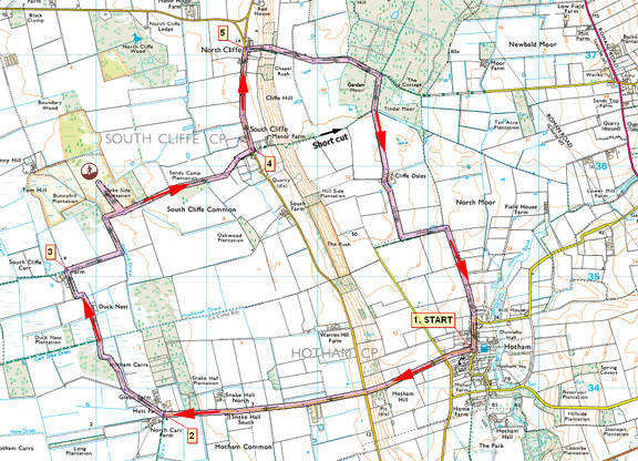

Route created using TrackLogs Digital Mapping
Image reproduced with kind permission of Ordnance Survey and Ordnance Survey of Northern Ireland.

- (Start) From the war memorial in Hotham set off up the road opposite the Hotham Arms, and straight on over Four Lane Ends crossroads. Continue up and over the hill down to another crossroads. Head west from here along a narrow lane, Carr Lane, which brings you in about 1Ľ miles (2.0km) to North Carr Farm
- (2.8km/1ľ miles) Bear right along the unfenced track (bridleway) across farmland. This leads into some scrubby woodland, in which are remnants of un-reclaimed marsh, and patches of gorse - a haven for a variety of wild birds, depending on the season. Leave the woodland and continue along the track, ignoring a footpath going left, and go through a gate. Continue straight on passing the ruins of a farm, shown as Duck's Nest on the map, following waymarks to a gap in the hedge. Go left then, in about 50m, right, to keep by the edge of this field until you meet a farm road near Carr Farm.
- (4.8km/3 miles) Turn right along this track, and follow it east then north to the corner of an area of access land at Bunny Hill. This can be explored via a kissing gate, returning to the same gate. This area is a complete contrast to the Wolds just four miles to the east. There are outcrops of heath land with thickets of gorse and bracken, and a fascinating area of pine forest. The soil here is a reddish brown, with evidence of sand in places, and is apparently ideal for growing carrots. Now continue east along the track for about 1km to the road at South Cliffe.
- (7.6km/4ľmiles) At the tiny settlement of South Cliffe turn left and walk along the road for about a mile (1.6 km) to North Cliffe. Take care as this road is quite busy with traffic making a short cut to the M62 (alternatively you can proceed straight up the hill in South Cliffe, shortening the walk by about 1.0km)
- (8.8km/5˝ miles) In North Cliffe take the bridleway right, up the hillside and onto Houghton Moor. At a crossing of tracks in the woods, turn right along a path which brings you to Cliffe Dales Farm. Go past the buildings and down the access road to a T-junction. Turn left along a track which becomes a grassy green lane as it swings round towards Hotham. Walk past the church to arrive back at the centre of this unspoiled village.(12.8km/8miles)
Along the Way

For those who normally associate East Yorkshire with the chalk landscape of the Wolds, Houghton Moor and its immediate area comes as a surprise. The acid peaty soil on this ridge of Jurassic sandstone provides ideal conditions for rhododendrons, bracken and conifers. The rhododendrons add colour to the scene when in flower in early summer.
If you have time, visit Hotham church with its short, sturdy tower. Also note the plaque on the wall of the Coach-house next to the church which commemorates the fact that this community was recorded in the Domesday Book of 1086.
Arnold Underwood (Feb 1997; updated Feb 2009, June 2015)
|
