
|
NORTH YORKSHIRE - Hackness
Hackness, Silpho and Broxa - 13.6km (8˝ miles)
'Not all misery'
The forested southern edge of the North York Moors National Park is intersected by several delightful, secluded dales. The area has a sense of remoteness but is surprisingly only a few miles from the hustle and bustle of Scarborough!
Criss-crossing the dales using forest and field paths results in an undulating route which, with some poor way-marking and indistinct paths, makes for a strenuous, sometimes tedious, but ultimately rewarding walk!
Featured in Country Walking Magazine Aug 2009
Fact File
|
Distance
|
13.6km (8˝ miles)
|
|
Time
|
4˝ hours
|
|
Map
|
OS Explorer OL27 (North York Moors East)
|
|
Start/Parking
|
Hackness Village Hall (Grid Ref: SE 968900)
|
|
Terrain
|
Undulating - Suitable for keen walkers
|
|
Grading
|
****
|
|
nearest Town
|
Scarborough
|
|
Refreshments
|
Pub at Langdale End (The Moorcock) and tearoom near Hackness (The Everley Country House Cafe). Also Hackness Grange Country Hotel - booking required
|
|
Toilets |
None
|
|
Public Transport
|
|
|
Stiles
|
4
|
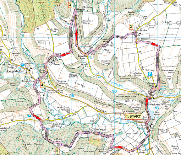
Image reproduced with kind permission of Ordnance Survey and Ordnance Survey of Northern Ireland.

- (Start) From the village hall cross the road to the pavement and walk north with glimpses through the trees of the Lake and Hackness Hall and Church. Follow the road round to the right but just before the buildings take the left turn for Silpho. After an initial straight this road zig-zags up the steeply wooded hillside. Ignore a path left at the first bend and continue on the tarmac round two further hair-pin bends (beware of traffic). On the next bend a footpath on the right takes you into Hilda Wood. Above a narrow wooded valley, this path climbs gradually to reach open farmland. At the next gate/stile bear left up across fields towards Silpho and at the road, turn right.
- (3.2km/2miles) In Silpho, note the strange stone-built tower which conceals the water tank serving this hamlet. Opposite this tower our route follows a bridle track down past fields to the top of Haggland Wood. Keep to the main track – the side branches served disused quarries. After a short distance along the edge of the wood the track begins to descend diagonally down the wooded hillside into Lowdales. At the bottom, turn left along the track and cross two streams by fords/footbridges near Lowdales Farm. This is a picturesque spot, particularly in spring and autumn. Now turn right to follow the narrow lane leading to Newgate and Highdales.
- (5.7km/3˝miles) The buildings at Newgate Gills are reached in about 1km (˝mile). Here turn left through a gateway crossing a bridge over a stream and then left again to pick up a footpath coming down from Highdales. After about 100m this path enters open pasture, which can be quite wet underfoot. Go though a gate and bear right up the hillside to a stile into a wood. Turn left and climb steadily up through the trees to emerge at the top within sight of Broxa. Walk down the side of the field then cut across diagonally right to a gate in the corner by Broxa Farm. Turn left through the village noting again the stone water-tower just like that in Silpho. On a bend, a bridleway branches right, down Broxa Bank. Initially the track is enclosed by trees and bushes, but half-way down you turn right emerging to be greeted by a panoramic view across Langdale End. On a good day this is a pleasant spot for a break to take in the view. From here a footpath heads straight down the hillside to Langdale Bridge, however a word of warning – the final part of the descent through gorse and scrub is very steep. Cross a stile to reach the road by the bridge. The pub is further up the road in Langdale End, past the tiny church.
- (8.0km/5miles) Cross the bridge and take a footpath on the left through gate into Bridge Farm, which like many isolated farms in these parts, seems to have seen better days.It can be very muddy here! After farm, cross a stone bridge and bear left past caravan site. After the next field the path turns right by a fence up the hillside towards the corner of a wood. At the top cross stiles and keep along the field edge to a gate. Join a track emerging from the wood and follow this down to the Troutsdale road. Cross over onto another track leading to Mount Misery. After dipping to cross a beck, this track then heads steadily uphill. Waymarks and signs in this area are not good, so keep an eye on the map and all around. Where the gradient starts to ease look out for a sturdy post on the left – at the time of writing, a post with no sign! Here, an indistinct path forks left up through bracken and bramble to a stile into the field at the back of Mount Misery Farm. Head across towards the farm, but stay in the field and walk round the perimeter of the farm yard through a gateway to the corner of the wood down to the left. Note it is very muddy here, with sheep and cattle (possibly including a bull)
- (11.2km/7miles) At the corner go into the woodland and pick your way along the edge of the forest for about 200yds before regaining farmland at another stile. The footpath, devoid of markers, now follows a series of grass fields round the hillside between upper and lower belts of woodland. Head from gate to gate, sometimes encountering clumps of gorse, which obscure the way ahead. Another wooded stretch is encountered above Wood House, after which the view opens out with Hackness directly ahead across the valley. However the path keeps more or less to the contour, so with end in sight, you find yourself swinging almost 180 degrees round the hillside away from Hackness! As you approach Comb Slack Farm – a riding centre – cross a stile and turn down an overgrown enclosed path diverting you past the horse paddock. Walk along the farm road to the junction with Lang Gate, with Hackness across to the left again, and down to Wrench Green. Go past the house with its tennis court and high level sun-lounge into this hamlet. At the end of the lane the map shows two footpaths but there is nothing to indicate them. Do not choose the footpath gate into a small wood, but go through the field gate, taking care not to let any of the inquisitive ponies escape! Walk down the side of the field to a footbridge over the Derwent. At the road, turn left back into Hackness.
Along the Way
Hackness is a typical estate village and has the unusual feature of a stream running alongside the main street
Hackness Hall dates from 1777 and is the home of Lord Derwent. It is not open to the public.

Arnold Underwood (Oct 2008, minor amendments March 2018)
|
