
|
PEAK DISTRICT
This route is featured in the Go Outdoors '10 Great Peak District Walks'

Eyam & Abney
A walk from the plague village of Eyam (pronuced 'Eem') over moorland and cloughs of the Peak District with extensive views south over the White Peak and north towards the Dark Peak. Take time out to explore the moving story of the villagers of Eyam and their self-imposed quarentine to prevent the spread of the plague in the 17th century. This walks passes the locations of two of the Plague Stones on the village boundary.
Fact File
|
Distance
|
14.0km/9 miles |
|
Time
|
4 hours
|
|
Grade
|
**** (strenuous)
|
|
Map
|
OS Explorer OL 24 (Peak District - White Peak Area)
|
|
Start/Parking
|
Eyam car park, grid ref: SK 220 768
|
|
Terrain
|
Field & moorland paths, tracks & minor roads
|
|
Nearest Town
|
Bakewell
|
|
Refreshments
|
Pubs at Eyam (in Town End) and at Bretton. Tearoom at Eyam Hall
|
|
Toilets |
Eyam car park and at Eyam Hall Craft Centre. Also at Abney Village Hall (if open)
|
|
Public Transport
|
Buses: 65 Buxton - Sheffield (TM Travel); 66/66A Buxton - Chesterfield (G&J Holmes (Mon-Sat), Hulleys (Sun)); and 275 Bakewell - Bamford/Sheffield (Hulleys) all serve Eyam.
|
|
Suitable for
|
strong walkers
|
|
Stiles
|
10
|
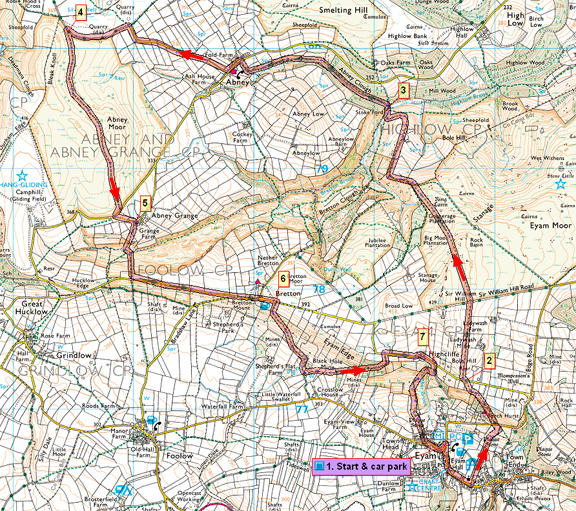

Route created using TrackLogs Digital Mapping
Image reproduced with kind permission of Ordnance Survey and Ordnance Survey of Northern Ireland.

- (Start) From the car park walk down into the village and turn left. Go along the main street past the Hall (you can visit here later) and past cottages displaying information relating to the fate of their occupants during the Plague. At the church, turn left (FPS) along the far side of the churchyard and squeeze through the tight kissing-gate. Cross an area of new housing and follow the path up the hillside. This emerges onto a road near Eyam Youth Hostel. Go left and across the road to follow a path, which climbs steeply up the wooded hillside onto Eyam Edge. At the top walk across a field and come to another road.
- (1.6km/1 mile) Go left a few yards than take a path on the right (FPS). This keeps to the field side over the hilltop with the chimney of the former Ladywash Mine prominent to the right. Soon the landscape changes dramatically as you enter an expanse of heather moor. There are wide-ranging views ahead over Bretton Clough and Abney Clough towards Hathersage and the Dark Peak, with a glimpse of Ladybower Reservoir. On the skyline left is Abney Gliding Club. A clear path leads across the moor dropping down towards Abney Clough, and at one point skirts the hillside on a ledge with interesting rock formations. From here the descent steepens down to Stoke Ford and a footbridge over the stream.
- (4.3km/2ľ miles) Pass some stone seats and follow the path left, up the wooded side of Abney Clough valley. At the road turn left into Abney village. Opposite the village hall turn right along a narrow lane. This lane winds up past high level pastures to the boundary wall of Abney Moor. Here the lane becomes a rough moorland track – turn left towards Bradwell Edge. This track can be busy with mountain bikes, moto-cross bikes, and even cars if paragliders are launching from Bradwell Edge! Follow this sandstone track round the hillside to where a footpath merges from the left.
- (7.3km/4˝ miles) Double back over the stile to follow this path across the moor. This path picks its way across Abney Moor with Abney Grange – our next target - ahead and the white buildings at Bretton on the ridge beyond. Gliders from Abney Gliding Club provide further interest. At a road, cross over and cut down by a fence to join the lane that loops round via Abney Grange.
- (9.1km/5ľmiles) Just before the buildings, a footpath sign on the right points the way over a wall stile and down the hillside. Cross another wall and pick your way down to the stream. Although the valley of Abney Clough is less deep here than it was further downstream, its sides are much steeper. Across the stream the footpath heads straight up – steps cut in the hillside don’t always help because some are extremely high! Ignore a tempting gate left, into access land, and plod onwards and upwards. At last the gradient levels out and you reach the road on the top of the ridge. Breath regained, you can now stroll along the road to Bretton for a welcome drink at the pub. Seats outside allow you to relax and take in the view south across Foollow and the patchwork of stonewalled fields.
- (10.8km/6ľmiles) Just on from the pub, a sign indicates ‘Footpath to Eyam’ which sounds promising, but things may not be as straightforward as expected. The path tracks diagonally down the side of the ridge towards an industrial eyesore shown on the map as Black Hole Mine. Pick your way down through gorse, where cattle may also have been and head for a footpath sign near the bottom corner. Cross a stile and walk towards the ‘works’. A notice ‘Footpath to Eyam avoiding works traffic’ points right, down a track. Walk down by the perimeter of the works past heaps of minerals and large bags and containers of various chemicals. Here a narrow path forks left taking you round the south side of the factory to bring you back into the works by a weighbridge. Here you may encounter ‘works traffic’ as you must cut diagonally left then right across the main entrance (white arrows on buildings) to a stile into rough grazing land. There are no signs now but head initially for a clump of trees, which conceal an old mine shaft, then keeping over to the left pick up a trace of a path by the wall. This becomes clearer as you leave the fields for the wooded hillside of Eyam Edge. It’s a steady climb through the trees, past another old mine shaft, before swinging left up to a field and to the road along the top. Turn right towards Eyam.
- (12.8km/8 miles) After a bend take a rough track down to the right opposite Highcliffe, then immediately right again at a footpath through a gate (Note: it is possible to continue down the track then the road, directly to the carpark in Eyam). The footpath contours round the head of Jumber Brook, and as you continue through woodland, the gill deepens considerably. From the woods, head down the open hillside into Town Head at Eyam. Turn left and walk back into the village, perhaps continuing as far as the Hall for a cup of tea at the Buttery Restaurant in the Craft Centre courtyard. (14.0km/9miles)
Along the Way
Eyam – The Plague Village
In 1665 the Plague was raging in London. George Viccars, a tailor from Eyam, had ordered some cloth from the capital and it arrived damp and was laid out to dry. This released the plague-carrying fleas and within days Viccars fell ill and died. Several of his neighbours also died and some families began to panic and fled the area. William Mompesson, the rector, feared that this would spread the disease over a wider area and asked villagers to quarantine themselves.
Food and medical supplies were left at various points (marked by Plague Stones) on the village boundary. Eyam church was closed and services were held in Cucklett Delf. There were no funerals and families buried their own dead near their homes. One of the last to die, in August 1666, was Catherine Mompesson, wife of the rector. She had loyally stayed with her husband and tended the sick, only to become a victim herself.
The Plague ended in October 1666 and had claimed 260 lives in an 18month period.
Today, one of our nursery rhymes has a special significance to Eyam:
Ring a ring of roses
A pocketful of posies
Atishoo Atishoo
We all fall down
A ring of roses - a red rash - was the first sign of the plague, the posies relate to fragrant flowers that were used to cover the smell of the infection and sneezing was the final stage of the illness before death.
A remembrance day to victims of the Plague is held at the end of August at around the time of the Annual Well-dressing, although the tradition of well-dressing pre-dates the plague by many centuries, possibly from pagan times. However the fact that Eyam had its own supply of pure water no doubt helped the village through its months of self-imposed quarantine.
The Parish Church of St Lawerence partly dates from the 12th century and probably stands on a Saxon foundation. The North Aisle was doubled in width in 1868. The South Aisle was enlarged and a porch added in 1882. Various other restoration work was carried out in the 19th century. The church contains a chair that was used by the Rev William Mompesson, a Jacobean pulpit, a Plague register, a Saxon font and a fine set of 6 bells, the oldest of which dates back to 1628. The churchyard contains various interesting tombstones and monuments including one to Catherine Mompesson. It also contains a magnificent Celtic Cross, one of the finest in the country and probably a wayside preaching cross from the 8th century
Mining
Mining in the area was originally for lead, but is now for fluorspar (originally waste material) with lead as a bi-product. Today, the mining into Eyam ridge is accessed from Great Hucklow and extends under the ridge as far as the old Ladywash Mine which was closed in 1990’s.
Arnold Underwood (Sept 2007, minor revisions March 2015)
|
