Dales Trails
 ____
____
|
|
NORTH YORKSHIRE MOORSCropton Forest & the River SevenHeading first north into Cropton forest and round via Spiers Bank to meet the River Seven at Hartoft in Lower Rosedale.The river is followed past Lower Askew and the walk ends with climb back up to Cropton villageFact File
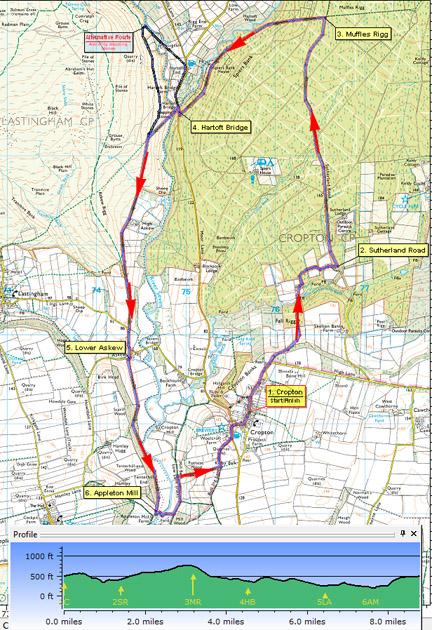
Image reproduced with kind permission of Ordnance Survey and Ordnance Survey of Northern Ireland.
1. (Start) Walk due north up the broad main street out of Cropton noting the interesting houses and cottages that border this road. The road narrows and does a loop near Sycamore Farm, which you on foot can cut out by using a narrow path on the left. Further on where the road bears right go straight ahead through a gate onto a footpath. Soon you begin a descent of the wooded slope of Cropton Bank. The downhill trend continues across open land and then more forest to a footbridge over Sutherland Beck. Across the bridge walk straight up the field to a gate between barns. Go through and bear right past stables and a bungalow to follow the driveway round to the left. Keep to driveway past more buildings and paddocks to arrive at junction with Sutherland Road. 2. (2.4km/1Ẅmiles) Now head north along this forest road for 2km. There is a mix of wooded and cleared areas so the surroundings are not as monotonous as you might expect. Also there are dips and turns in the road, suggesting that this forest track does follow the line of ancient road. Eventually you reach a junction with another forest road, which comes straight up from Spiers house continuing up to Muffles Rigg. Our route now continues straight ahead as a narrow bridleway through the trees (blue waymark). In places this path can be wet and boggy as it picks its way through the forest. Here the fir trees are tall and well spaced so there is a light and airy feel, not dark and claustrophobic, as in many conifer forests. After about 0.5km you emerge onto another forest road at a bend. On your right a yellow waymark indicates a path along Muffles Rigg our route is in the opposite direction, on your left. 3. (5.1km/3ỳmiles) Here a narrow path descends quite steeply down through the trees. Take care there are some awkward rocky sections to negotiate which are likely to be wet and slippery. Safely you spill out onto a forest track. The path continues its downward trend of Spiers Bank directly opposite to bring you to another track. Here go slightly left to pick up the continuation of the path (waymarked here) down to yet another forest road looking very much like the previous ones! However this time you turn left and follow this track for 1.5km, past Spiers Bank House with its flags flying, to the Rosedale Road near Hartoft Bridge. 4. (7.5km/4ẅmiles) Turn right to cross the bridge, then cross the road to a footpath opposite alongside Hartoft Beck. Follow the path over stiles to the confluence of the beck with the River Seven. Here stepping stones lead across the river. If the river is low it should be possible to cross here, although one stone has been shifted out of place and could be awkward.(If it is not possible to cross the stepping stones you must return to the road and walk up past the Blacksmith's Arms and take a footpath on the left down to a footbridge across the river). Where the path from the stepping-stones joins the main track you pass the site of a medieval glass works (marked by a plaque). Beyond High Askew Farm, over to your left, the condition of the track improves, becoming a metalled lane to its junction with the Lastingham Road. Walk on along the road into Lower Askew continuing straight on to a gate & stile at the road corner. 5. (11.0km/6ẅmiles) Walk up the side of the field and enter Scarth Wood. Here youll find a succession of wild flowers in spring from daffodils in March, wild garlic, primroses, and bluebells in May. Keep to the lower narrow path, which follows the edge of a steep wooded bank falling away to the river below. The path merges with a broad track and a gate you exit the woods. Follow the edge of a large field round below the wooded hillside towards Appleton Mill Farm. 6. (12.5km/7ẅmiles) Do not leave the field, but double left back round the edge of the field to a sturdy wooden bridge over the river. Walk away from the bridge up a muddy track to a t-junction (SP) and go left. In a short distance go right (no signpost) to follow a tractor track up a shallow gully. This climbs out of the valley and for the last part of the climb becomes surfaced with stone chippings. At the top, this track joins Bull Ing Lane and here turn left. This enclosed green lane brings you into Cropton near to the New Inn. The High Street is a short distance along from the pub round to the right. (14.4km/9miles)
Along the WayCropton is a typical moorland village with robust but attractive cottages bordering a wide main street.
Arnold Underwood (March 2008, Revised Oct 2017)
|
Arnold Underwood