|
YORKSHIRE WOLDS - Secret Valleys
As featured in Country Walking Magazine February 2003
Sledmere Monument to Cottam and Cowlam
The landscape of the Yorkshire Wolds, towards Bridlington, is sparsely populated. Minor roads criss-cross the rolling countryside, which is dotted with isolated farms and the sites of long-gone villages. This is a secret corner of Yorkshire, much of it inaccessible to the country walker. Fortunately bridleways lead up the two dales featured in this walk, to the sites of the medieval villages of Cottam and Cowlam.
Fact File
|
Distance
|
13km/8 miles
|
|
Time
|
4 hours
|
|
Grade
|
**(moderate)
|
|
Map
|
OS Explorer 300, Howardian Hills & Malton
|
|
Start/Parking
|
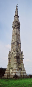
Tatton Sykes Monument on the B1252 Driffield - Malton road (grid ref: SE 958 619)
|
|
Terrain
|
Field paths and bridleways across undulating farmland
|
|
Nearest Town
|
Driffield
|
|
Refreshments
|
none
|
|
Toilets |
none
|
|
Public Transport
|
bus 135 Driffield - Sledmere (3 per day, none Sundays) |
|
Suitable for
|
all (be aware of frisky horses at Cottam Grange)
|
|
Stiles
|
5
|
- (Start)Set off due east down a lane by the side of Monument Cottage, signed to Sledmere Grange, opposite the Sykes Monument. Pause to take in the view across the Wolds - note in the distance to the northeast, a white house - this is Cottam Grange which you will pass later. The lane follows the route of a Roman road - York Road (Woldgate). So like the Romans of centuries ago, you can stride out along this lane. Initially metalled, this lane becomes a rough chalk track beyond the entrance to Sledmere Grange. After about 2km (1˝miles) it dips steeply down to meet a minor road in Garton Bottom.
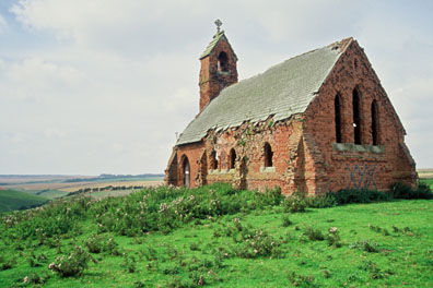
- (2km/1Ľmiles) Here we leave the Roman alignment (which continues straight ahead as a bridleway) and turn left. About 400m (Ľmile) along the road, take to a bridleway at a wooden gate on the right (waymarked) and head into Cottam Well Dale. The valley twists and turns and it is easy to lose a sense of direction. The route keeps to the bottom of this secluded dale for about 3.2km (2 miles), but be sure to swing right at the junction (wooden finger-post) with Cowlam Well Dale - that is your return route. Concrete structures set into the sides of the dale hark back to World War II when there was an airfield at Cottam. You have to negotiate a zig-zag through a pair of gates. The dale twists again, and the tiny brick-built ruined church at Cottam comes into view and a steady pull brings you up to the head of the dale.
- (5.5km/ 3Ľmiles) Pause by the church and survey the surrounding countryside (but do not stand too near the building as the slates on the roof are unstable!). The earthworks in the immediate vicinity are all the remains of the medieval village of Cottam. Sheltered by trees, Cottam House stands on the edge of the village site.
(The wartime airfield was just to the south and can be investigated by following a bridleway round the eastern side of Cottam House. To continue this walk you will need to return to the church.) Head north away from the church to cross a stile and maintain direction along a field boundary, aiming for the white house at Cottam Grange. The path crosses a dip in the landscape and comes up to a fenced paddock. Cross a stile and keep along the right-hand side of the paddock to a stile by the gate in the corner near a cottage. This paddock was home to a couple of frisky horses which become rather excited at the sight of walkers, particularly if they have dogs. The ground here can be rather sticky.
- (6.5km/ 4miles) Once over the stile, maintain direction along the lane past the barns of Cottam Grange. After a further 500m you reach the highest point on this walk (160m /520ft above sea level). Prominent on the skyline to the southwest, like a rocket on its launch pad, is the Sykes Monument. Turn left at a half-hidden way-marked post down a track to the right of a hedge. Go through a small gate and you find yourself overlooking a steep-sided dale, shown on the OS Explorer map as 'Phillip's Slack'. Carefully pick your way down the hillside and head southwest down this valley. After about 1km (ľ mile) this dale merges with Cowlam Well Dale. (If you wish to visit the site of Cowlam village and church you will have to turn right up Cowlam Well Dale and then either return to this point or walk down the road to Garton Bottom. This would add about 3.2km (2miles) to the walk)
- (8.5km/ 5Ľmiles) A short distance on, this valley re-joins the main Cottam Well Dale at the signpost mentioned earlier. Here you bear right and retrace your steps to the minor road through Garton Bottom. A little way along this road, turn right up the chalky track for the return leg up hill back to the Tatton Sykes Monument (13km/8miles)
Along the Way
The 120ft high Monument was erected in 1865 'in memory of Sir Tatton Sykes, Baronet, by those who loved him as a friend and honoured him as a landlord'. The squire, known affectionately as 'Old Tatters', was indeed well respected by one and all.
First the Black Death then changes in farming in the 18th century, with the open grassland being transformed into prime arable land, brought about the demise of the twin villages of Cottam and Cowlam. Today, Cottam church is derelict and unsafe, but that at Cowlam is still used occasionally and stands behind Church Farm.
In World War II, an airfield was built near Cottam House, but it was never fully operational. Nowadays, in late summer, the landscape is a scene of frenzied activity as the harvest is gathered in, and it is the wheels of farm machinery that rumble over the remaining concrete roads and runways of the old airfield.
Arnold Underwood & Caroline Gowthorpe (Feb 2004)
|