
|
NORTH YORKSHIRE COAST - Cloughton to Hayburn Wyke and beyond
'Hayburn Wyke & Staintondale' - 14.5km/9 miles
This walk is yet another variation on my routes in the area, taking in Hayburn Wyke, Cloughton Moor and woods. Heading north on the Cleveland Way brings a panoramic view of Hayburn Wyke. Beyond the Wyke, the route follows quiet lanes and paths into Staintondale, and joins the railway path near the former Staintondale station for part of the return to Cloughton.
Fact File
|
Distance
|
14.5km (9 miles)
|
|
Time
|
4 hours
|
|
Map
|
OS Explorer OL27 North York Moors East
|
|
Start/Parking
|
Cloughton old railway station - former goods yard, grid ref: TA 012 940.
|
|
Terrain
|
Cliff-top path, field and woodland paths, disused railway
|
|
Grading
|
*** moderate but extra care needed descending to Hayburn Beck
|
|
nearest Town
|
Scarborough
|
|
Refreshments
|
Pubs in Cloughton and at Hayburn Wyke. Tea-room at Cloughton Old Station.
|
|
Toilets |
Cloughton Old Station tearoom (for customers)
|
|
Public Transport
|
Cloughton is served by buses 115 (Scarborough & District - ˝ hourly - not Sundays) and 93/93A (Arriva North East - hourly - daily).
|
|
Suitable for
|
All - Take care on cliff-top path. Cattle and sheep in the vicinity of The Hulleys
|
|
Stiles
|
8
|
Route created using TrackLogs Digital MappingImage reproduced with kind permission of Ordnance Survey and Ordnance Survey of Northern Ireland.

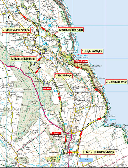
- (Start) By the former station at Cloughton join the disused railway and walk north until the first overbridge. Climb the steps to join the minor road and walk along this lane to its end at Salt Pans, Cloughton Wyke. Here join the Cleveland Way heading north along the cliff-top. After dipping down the path climbs quite steeply to cross a wooded headland from which there are views south back towards Scarborough and beyond. Ahead the land drops away towards Staintondale and Ravenscar.
- (2.5km/1˝miles) Continue north with occasional glimpses of the sea far below on your right. As the path starts a gradual descent more gaps in the undergrowth reveal the rocky bay of Hayburn Wyke ahead. A National Trust sign marks the entrance to the wooded valley of Hayburn Beck, into which the path descends steeply. Bear right continuing the downward trend and you reach the level of the beck. A footbridge leads the Cleveland Way across and on its journey north. However do not cross but continue down to reach the rock step over which the beck tumbles to the shore below. It is possible to scramble down to the right to view the waterfall from below, but take care on the rounded boulders on the shore.
- (4.0km/2˝miles) Continue by retracing your steps up past the footbridge, but now keep to the wide path, parallel to, but high above Hayburn Beck. Take a right fork to follow a path down and across the beck at another footbridge. Now it is simply a matter of following the course of the beck up the wooded dale, ignoring any paths off to the right. Take care though as the path has been badly eroded in places. However this is a delightful walk at any time of the year in company of the beck as it tumbles down to the sea. Eventually the path emerges from the wooded confines of the dale and joins a tarmac lane to a junction by Whitehouse Farm.
- (5.5km/3˝miles) Turn right here to follow the narrow farm road past the Shire Horse centre and on through a unspoilt, unvisited country between the coast and the old railway. Go round past Plane Tree Farm and on up to White Hall Farm, where the barns have been tastefully adapted as holiday cottages. Here turn left through a gate into a field and head downhill to join an enclosed path. This drops down into the the valley which is covered with quite dense shrub and scrub. The path zig-zags down, crosses the beck, and climbs steeply up the other side. It can be wet and boggy and not frequently walked around here. Pick your way up through the undergrowth to a gate and the disused railway below the scattered community of Staintondale. Turn left and head south and in about 800m (˝mile) you reach the former Staintondale station, now a private house. However the disused platforms to provide a convenient seat on which to perch and take lunch.
- (8.0km/5miles) After a break continue south along the old railway – beware of cyclists on this section. The whole of this old railway is now bordered by trees so is quite sheltered but views are restricted. The track passes under a bridge and begins to curve left and about 400m (Ľmile) further look out for a gate/gap in the fence on the right. This is about 100m (100yds) before the next bridge. Here a path cuts up across an overgrown field to join a farm track which heads up through a small-holding (where vegetables may be for sale) to a gate onto the Staintondale Road, opposite a lonely red mailbox.
- (9.6km/6miles) Turn left and walk up the road and round the bend for about 200m (200yd) - take care as this road can be quite busy with traffic to and from Ravenscar. On the right a bridleway heads up the side of conifers towards the forested Cloughton Moor. At the top, the path turns left through a new gate. Route finding here can be tricky – it is probably easiest to continue ahead along the top of the forest until the faint path swings right and descends through bracken and bramble. It can be wet and boggy in the hollow. Pick your way across and continue up the other side to reach the corner of a fenced area which has been cleared. Turn left opposite a gate in the fence to follow a rutted track through the trees. In about 400m (Ľmile) look out for a waymark indicating a narrow path on the left. Follow this down to meet another track at a gate. Go through the gate and double back left on boggy ground to cross a stream by a boardwalk bridge. Climb up the other side to reach the farm at The Hulleys (note there may be cattle here). Go through the gate between the barns and along the farm road to reach a footpath sign pointing south towards Cloughton.
- (11.2km/7miles) Turn right as indicated, through the gate, and follow the track along the field edge of this ridge that drops gradually down to Cloughton. Ahead can be Scarborough and beyond. Again these fields are likely to contain cattle. The path passes patches of gorse and goes through a belt of woodland before finally leaving the fields for a rough enclosed track down to a gate and the main road at the edge of Cloughton village. Take care and cross straight over to find a narrow path running behind the gardens of the houses opposite. Soon you emerge from the restricted confines of the path onto Cloughton cricket field. Walk along the by the beck which forms the east side boundary to reach a lane. You can turn left here up into the centre of the village, particularly if you want to visit the pub. Otherwise continue to follow the beck down stream past a patch of woodland and take the next lane left. This takes you past a cemetery up to the main road, opposite Station Lane. Cross over and walk down the lane back to the Old Station (14.5km/9miles).

Along the Way
The coastline north of Scarborough is broken by numerous 'wykes' - old Yorkshire for a small inlet - too small to be called a 'bay'. Of these, Hayburn Wyke is probably the most attractive, with the beck tumbling over a waterfall onto the rocky shore.
None of the ‘wykes’ are particularly accessible, but with the coming of the railway in 1885 a station and hotel were built above Hayburn Wyke to attract visitors to the area. The railway was dismantled in the 1960’s but the track-bed is now designated as a permissive recreational path, and is popular with cyclists
Arnold Underwood (July 2007 and July 2009)
|
