|
NORTH YORKSHIRE MOORS - Cawthorne - (14.5km, 9miles)
'Surprise Views'
The site of the Roman Camp in the forest at Cawthorne provides an ideal starting point for a walk taking in forest and moorland leading to the escarpment edge overlooking Newtondale. After a break at Newton-on-Rawcliffe the return is via open farmland.
Fact File
|
Distance
|
14.5km (9 miles)
|
|
Terrain
|
Flat - A mixture of moorland and woodland paths & bridleways, boggy in places, and minor roads
|
|
Time
|
4˝ hours
|
|
Stiles
|
5
|
|
Grading
|
*** moderate
|
|
Suitable for
|
all
|
|
Start/Parking
|
Cawthorne Roman Camp, north of Pickering (Grid Ref: 783 897) |
|
nearest Town
|
Pickering
|
|
Refreshments
|
Mucky Duck Inn at Newton-on-Rawcliffe
|
|
Toilets |
none
|
|
Public Transport
|
Moorsbus from Pickering serves Newton-on-Rawcliffe and Cawthorne Camp entrance (Suns & Bank Hols, Easter – October)
|
|
Map
|
OS Explorer (OL27) North York Moors East
|
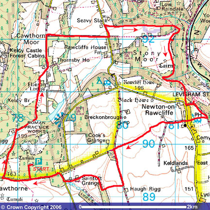
Image reproduced with kind permission of Ordnance Survey and Ordnance Survey of Northern Ireland.

- (Start) From the car park, walk back down to the road and turn right. In about Ľmile turn right at the junction (SP Keldy). Head north along this lane for about ˝mile – it can be quite busy with traffic to and from the Forest Cabins at Keldy. From the top of the hill you get a good view north over the forest. Opposite a farm at the bottom of the hill take a path (no SP at present) on the right into woodland. This path picks its way through mixed woodland with views right of the escarpment on which is situated Cawthorne Camp. The path swings north to cross a stream and climbs steadily until the woodland thins and you come across open farmland. Head across the field to the gate opposite – High Cawthorne farm is to the left and Elleron Lodge through the trees on the right..
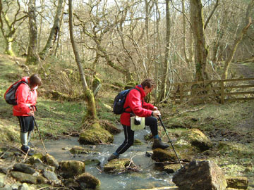
- (2.5km, 1˝ miles) Through the gate immediately bear left along a rough track (do not go through a second gate onto the driveway from the Lodge). Head along this track (shown as Middle Head Road on the OS map) with open farmland on your left, forest on the right. At the end of the forest turn right (east) along another track (SP Tabular Hills Walk). This rutted track passes the edge of the forest and emerges into open country as it drops down to meet a minor road near Stape. Do not cross to the footpath opposite but turn left up the road for about 100yds, and then turn right along a forest road. (SP Tabular Hills Walk). Where this road turns down into Raindale, go through a gate on the right (blue waymark) and follow a bridleway along the field edge with woodland on your left. The going can be sticky here as the bridleway passes through a succession of gates before re-entering woodland. In a few yards you come to an intersection of paths.
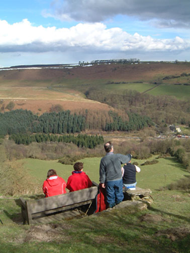
- (4.7km, 3miles) Here continue straight on (SP Footpath). The woodland becomes thicker and the path less distinct before it swings right to avoid a steep gully that drops down into Raindale. You arrive at a gate at the top of this gully, but instead of turning downhill go through the gate into an area of scrubby moorland. Not shown on the map a well-used trod heads left across peaty ground. A faint path left takes you to a stunning viewpoint on the edge of the escarpment overlooking Newtondale. Ahead the NYMR can be seen threading its way down to Levisham Station on its way to Pickering, whilst across the valley is the moorland of Levisham Bottoms and beyond. Having savoured the view, return to the main path and follow this as it heads south, parallel with the escarpment. This path, favoured more by those on horseback or mountain bike, picks its way through the scrub and can be very boggy underfoot. The trend is gradually downhill and the ridge on which sits Newton-on-Rawcliffe looms up ahead. The path bears right down into Raygate Slack to a stream and a bridleway.
- (7.5km, 4˝miles) Cross the beck and go through the gate. You are now on a bridleway, which is followed as far as Newton. Keep to the main track as it contours round the hillside before climbing steadily up Newton Bank, passing a cattle shed to arrive at the northern edge of the village. The pub is just down the road by the pond but if it is good weather save this till later and turn left along the lane for a few yards. Cross a stile to find a seat at the top of Newton Bank with a panoramic view across Newtondale -there can’t be many better places for taking a lunch break. Levisham Station is down below, looking like a model railway, and across to the left on the edge of the moor can be seen Skelton’s Tower.
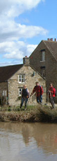
- (9km, 5˝ miles) Climb back over the stile and go left along the lane for about 400yds. Turn right (footpath SP) to walk by a field and caravan site to emerge in Newton-on-Rawcliffe by the pub – The Mucky Duck, formerly the Black Swan. Opposite on the green is a large pond, complete with ducks. Head diagonally left from the pub to find a narrow lane heading west between barns and cottages – the barns now themselves converted into homes. At a junction of tracks in about ˝mile, continue straight ahead (in fact a slight right-left kink) to follow a tractor track along the field edge across open, rolling country. The track turns left and then you turn right to maintain the westerly direction with hedge on your left. It can be sticky underfoot.
- (11km, 7miles) At the field corner descend a bank onto a lane and turn left. Walk past a disused quarry, now unsightly with dumped rubbish, ignore a track to the right, and continue south for about 400yds. Turn right along a field boundary (just before buildings) with a hedge on your left. This track dips down through a disused sand quarry (now used for motorcycle scrambling) and round to the extensive farm at Saintoft Grange. Walk between the large cattle sheds to be greeted by a confusion of footpath signs. The right of way skirts round some of the barns and past the farmhouse, but a permissive path provides the best option – straight through! This leads straight down the driveway past a cottage with dogs, ducks, geese, goats and turkeys – you won’t sneak past here un-noticed!
- (12km, 8miles) At the road turn right and walk up to the T-junction. Turn left and the entrance to Cawthorne Camp is in about Ľ mile.
Back at the car park, study the information board about the Roman Camp and explore the way-marked trail round the site. About halfway round you can survey much of your walk from the top of Cawthorne Banks.
(14.5km, 9miles)
Along the Way
Cawthorne Roman Camp was constructed in about AD100. It lay forgotten for centuries, becoming overgrown with forest and scrub, until being excavated by a Professor Richmond in the 1920s. Research has shown that the site was used by the Romans as a practice ground for building fortifications rather than as a settlement in its own right. A Roman road heads north from the site and a well-preserved section exists on Weeldale Moor, near Goathland.
The 50mile Tabular Hills Walk connects Helmsley with Scarborough thus forming a link between the ends of the Cleveland Way
Arnold Underwood (March 2005)
|