|
NORTH YORKSHIRE - Castle Howard
Round Howard's Way
This is a pleasant walk in the Howardian Hills Area of Outstanding Natural Beauty - a fact proclaimed on the many signposts - with the added bonus of the House and parkland of Castle Howard itself. Spring, with the new growth and woodland flowers, and autumn with its golden colours and fungi, are the best seasons for exploring this area.
Fact File
|
Distance
|
16km (10 miles) - can be shortened to 11.5km (7˝ miles) |
|
Time
|
4 hours
|
|
Grade
|
*** Moderate
|
|
Map
|
OS Explorer 300 (Howardian Hills & Malton)
|
|
Start/Parking
|
Opposite the Great Lake (grid.ref: SE 708 712)
|
|
Terrain
|
Undulating field paths and bridleways - can be quite muddy in places.
|
|
nearest Town
|
Malton
|
|
Refreshments
|
None on route - tearoom and pub in Welburn, Courtyard tearoom at Castle Howard
|
|
Toilets |
none
|
|
Public Transport
|
Hutchinsons 182/183 - one bus each way from Malton serving Coneysthorpe not Sundays.
Moorsbus M4 from Helmsley (Sundays & Bank Hols April - Oct plus Fri,Sat & Mon 23 July - 30 Aug).
Welburn is better served by service 81 (Malton - York)- not Sundays.
|
|
Suitable for
|
all - dog owners be aware of horses on the bridleways.
|
|
Stiles
|
none
|
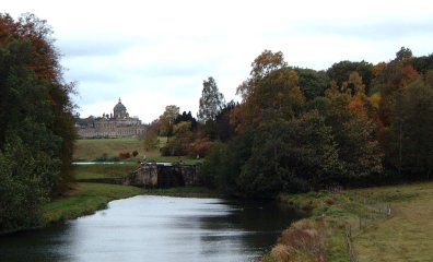
- (Start) From the parking area cross the road, pause to admire the view of the 'Big House' across the lake, and then walk back to the crossroads and turn right for Coneysthorpe. Walk along the road for about Ľ mile to Coneysthorpe and there turn left up the side of the large village green. For the first leg of this walk you follow the Centenary Way. Go past the small chapel onto a track which dips to the left then follows a straight course up the side of fields towards the wooded Coneysthorpe Bank. At the wood the path turns left then right. 'No Right of Way' signs ensure that you do not go astray. You are now faced with a steady climb up the wooded hillside - becoming steeper and quite muddy towards the top!
- (2.5km, 1˝ miles) You emerge from the wood on top of the ridge where there extensive views north over Ryedale to the North York Moors. Turn right, leaving the Centenary Way and follow the edge of the woodland. After about a mile you meet another track and cross straight over to continue along the ridge. In a further ˝ mile the path swings down to the right and round through a paddock by Easthorpe Farm Go through a gate onto the driveway and walk down the drive past Park House to the road.
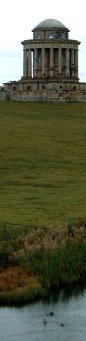
- (5km, 3 miles) Cross over and follow the track as indicated, which dips to the left and then swings round to the right and quite steeply downhill. There are views from here across the Castle Howard estate with the Mausoleum prominent. This edifice will be a recurring landmark throughout this walk. Follow the bridleway round to the left, through a gate and along below Spring Wood. As you approach farm buildings, shown as Alamo Trekking Centre on the map, you will find that footpath has been diverted around the grounds. Follow this diversion to a T-junction of tracks and turn right (signposted High Gaterley). Head due south on this track (shown as Thackadale Lane on the Explorer map), through another gate and up by Gaterley Plantation. Here there is another view of the Mausoleum to the west. At the top (FP sign) continue straight on, soon coming to a junction with another track. Turn right towards High Gaterley.
- (7.8km, 5 miles)( For a short cut you could continue along this lane to meet up with the main route again at point 6).
Otherwise by the farm turn left at a bridleway sign (Hutton Hill) and walk by the side of the barns, passing through several gates as you go down hill to a footbridge over a stream. The open hillside ahead is intensively farmed with a variety of crops - potatoes in particular. Directly ahead from the footbridge, tractor tracks show the line of the path straight up the hillside to a gap in the hedge below electricity transmission lines. At the top follow the track under the cables, turning left and then right down the side of the field to the farm at Hutton Hill. (Ignore the waymark on a gate showing the right-of-way across a paddock into the farmyard.) At the farm you will come to a footpath sign - turn right here to follow the path towards Welburn.
- (9.3km, 6 miles) This path keeps alongside a hedge and then dips down towards a wood. Go through a gate and bear left into the wood, crossing a small stream. This area can be wet and overgrown. A narrow path picks its way through the undergrowth and heads up hill out of the valley. Continue forward by the side of a field to meet another track and signpost.
(If desperate for refreshment you could continue to the pub in Welburn from here by turning left and following the signs for Welburn. Return from Welburn along Water Lane and up through the woods to point 6). Otherwise, turn right (FP to Coneysthorpe) through a gate and walk along the field side. Follow the bridleway due north to a gate where you once again enter woodland. At the top the path swings left, but take a small detour to the right to visit the recently restored 'Four Faces' monument. Now continue along the woodland track, which after about ˝mile turns right out of the wood down to the lane from High Gaterley.
- (11.8km, 7˝ miles) From here notice the Pyramid and the view of the 'Great House' of Castle Howard to the left, the Temple and New River Bridge straight ahead, and the Mausoleum to the right. Take the track leading down to the bridge where again you should pause to take in the scene. Go through the gate and head diagonally left across the field, where there may be cattle, passing close to the Temple (not accessible from this side) to come alongside the boundary Ah-ah wall of Castle Howard's grounds ( Note:the actual right-of-way heads straight across this field). As you walk along the track below the wall you may experience the disconcerting sight of other people looking down on you from the other side of the wall. This is because there, the ground level is near to the top of the wall giving an uninterrupted view from the House across the estate.
- (9.6km, 8˝miles) Go though a gate and follow farm track back towards Coneysthorpe. A footpath sign indicates a short cut across the grass but otherwise keep to the stony track. As you approach the gate onto the road you will need to veer left across the grass to leave via the smaller pedestrian gate. Turn left and retrace your steps through Coneysthorpe back to your car.(16km, 10miles)
Along the Way
Castle Howard, with its immense façade, is one of England's grandest and best-known houses. Designed by Sir John Vanbrugh and built between in 1699 and 1726, for the 3rd Earl of Carlisle, it has remained the home of the Howard family for 300 years. The house contains some fine furniture and paintings, whilst in the surrounding parkland can be found the Mausoleum and the Temple of the Four Winds, along with other monuments and follies.
Arnold Underwood & Denise Middleton (October 2003, Revised January 2006)
|