|
EAST YORKSHIRE - Bracey Bridge
Twixt Wolds and Sea – via some delightful villages
A 'bracing stroll' where the Yorkshire Wolds drop down to Holderness and the North Sea, passing a ruined church, a lost manor, a haunted well and visiting the village of Kilham, one time ‘Capital of the Wolds’
Fact File
|
Distance
|
14.5km / 9miles
|
|
Time
|
4˝ hours
|
|
Map
|
OS Explorer 295 (Bridlington & Driffield)
|
|
Start/Parking
|
Bracey Bridge lay-by on A614. Grid Ref. TA 077 620
|
|
Terrain
|
Field paths, tracks & minor roads. Can be muddy in places
|
Grade
|
** (easy)
|
|
nearest Town
|
Driffield
|
|
Refreshments
|
Pubs in Harpham, Burton Agnes, and Kilham and shops in Kilham. There is often a mobile snack bar at the Bracey Bridge lay-by.
|
|
Toilets |
none
|
|
Public Transport
|
Bracey Bridge lay-by and Burton Agnes are on the East Yorkshire 121 bus route Hull - Driffield - Bridlington - Scarborough. Harpham and Kilham are served by less frequent local services (125, 126).
|
|
Suitable for
|
for everyone.
|
|
Stiles
|
12 (some awkward for dogs)
|
- (Start) Towards the western end of the lay-by go through a metal gate on the left (although marked private there is a stile and a footpath sign in the undergrowth, right of the gate). Walk along the farm track with a pond among the trees to your left. Where the track swings down to the old mill continue straight on along the top by the field side, possibly confined by an electric fence.
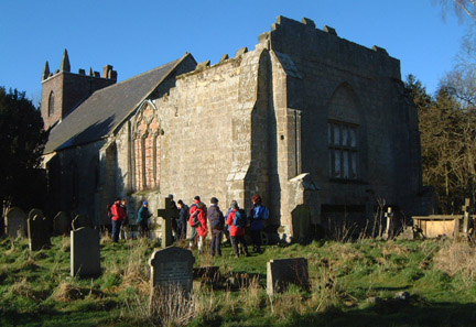
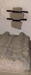
Head across the field to a gate and a junction of paths. Through the gate turn right alongside the hedge towards a corner of a wood. Walk down the side of the wood to a road and turn left towards Lowthorpe.Tucked away in the wood is an historic church, which is well worth a visit. Turn left along the driveway and enter the churchyard - the present day St Martin's church adjoins a ruined chancel, said to be part of a former monastry. Just inside the church is a most unusual carved gravestone, representing a man & woman and their thirteen children. Part of ancient Saxon cross is fixed to the adjacent wall.
- (1.6km/ 1 mile) Back at the road continue into the village and cross a stile on the left, near the phone box. Walk across two fields and join a track. Go left, then immediately right along the edge of two more fields to a footbridge over Lowthorpe Beck. See if you can spot any trout in the clear waters of this stream, which is one of the main tributaries of the River Hull. At the road turn left towards Harpham. In about 200m (220yds) look out for a footpath on the right - this makes a bee-line across fields towards Harpham church. In the second field you will come across the Drummer's Well and the earthworks of the old manor. From near a tennis court you can either go straight on through a gate to reach the St. Quintin Arms, or right to visit the church.
- (4km/2˝ miles) In Harpham, at the crossroads, look for a stile by the old chapel, now converted into a home. Go along this path and enter a field by another stile and head diagonally across. Go over a footbridge and keep to the field edge until another stile is reached. Cross over and head half-left diagonally across fields to arrive at a stile by a gateway in the opposite corner.
- (5.6km/3˝ miles) At the main road turn right into Burton Agnes village. At the first road junction, opposite the Blue Bell Inn, go left up the hill past the school. (For a glimpse of the Elizabethan Hall you will need to continue into the village and take the next left) Just beyond a sports field, turn left at a footpath sign. This path keeps to the field edge, before dipping down and up across a field. At the next field boundary the path swings to the right to head diagonally across to a gate onto a narrow lane.
- (7.5km/4ľ miles) Here the footpath continues straight on across several more fields, with crops, cows, and sheep to contend with, so it is much less tedious to turn right along the lane. At a bend this lane becomes an un-metalled track bordered by a line of trees. At the end, go through a gate and walk along the road towards Kilham. You could follow the road all the way to the village, but to keep off the tarmac turn left at a footpath sign, which takes you down by a turkey farm. By the sewage works, follow the field round to the right to a footbridge and a stile. From this stile, head diagonally across a meadow to a gate and follow the track into Kilham village, by the pond, where there is a conveniently situated seat.
- (10.4km/6˝miles) Turn left and walk through the village. There are shops and a couple of pubs in this large village. By the church pause to read something of Kilham’s history on the informative map and note the bull ring in the wall opposite. Ignore a footpath to the left and continue past the Old Star Inn and turn left at the next road junction. Go past the Blacksmith’s Cottage B&B and turn left again (footpath sign) into South Grove. At the end of the track cross the stile into a field and continue forward keeping to the higher ground. (If you drop down to the left you will be back at the sewage works!).
- (11.6km/7Ľmiles) The footpath now heads across several fields back to Bracey Bridge. Look for stiles or gaps in the field boundaries. Waymarking is not all that clear and some fields maybe ‘set-aside’. The right-of-way passes under power lines and swings to the left as you approach a woodland plantation. Here, a yellow waymark indicates that the path should be between the first rows of trees in the plantation. However this does get overgrown with nettles, so it is easier to walk along the edge of the plantation. Cross a stile and climb up the embankment to the A614. Climb over the crash barrier and cross this busy road with care. Drop down the bank on the other side through the bushes to arrive back at the picnic site and lay-by (14.5km/ 9 miles).
Along the Way
If time permits explore the earthworks of the old hall in the fields near the church in Harpham. Near these earthworks is the haunted Drummers Well. It is said that the sound of the drum forewarns of the death of a member of the St Quintin family.
Kilham sits in a sheltered hollow on the Roman Road (Woldgate) linking York and Bridlington and it is here that crystal-clear water appears from below the chalk of the surrounding hills. The name Kilham comes from the Anglo-Saxon for settlement by the springs.
In the Middle Ages, Kilham was the capital of the Wolds, and was awarded a royal charter to hold a market. But with the coming of the canal and the railway in the 19th century, Kilham lost out to Driffield, and the village is now a quiet agricultural community. However, the nine roads that converge on the village from across the Wolds, the church, and some large 18th Century houses in the main street are reminders of its former importance.
The red-brick Elizabethan Hall at Burton Agnes is open to the public from April to October. Adjacent to the hall is the Church and the Manor House, dating from Norman times.
Arnold Underwood/HWC (Feb 2001/Jan 2005)
|