|
NORTH YORKSHIRE - Blubberhouses
'River & Reservoir' - The Upper Washburn Valley
Yorkshire Water has opened up many walking opportunities by creating permissive paths around their reservoirs in the Washburn Valley. This walk follows a riverside path, from quaintly named Blubberhouses, at the head of Fewston Reservoir, to the dam at Thruscross and then onto the moors around Thruscross Reservoir.
Fact File
|
Distance
|
15km/9˝ miles
|
|
Time
|
4˝ hours
|
|
Map
|
OS Explorer 297 Lower Wharfedale/Upper Washburn Valley (Note: Older maps may not show the permissive paths)
|
|
Start/Parking
|
Blubberhouses Car Park (Yorkshire Water) Grid.Ref: SE 168 554
|
|
Terrain
|
Field, moor & waterside paths, and minor roads
|
Grade
|
*** (moderate)
|
|
nearest Town
|
Harrogate
|
|
Refreshments
|
Pub – The Hopper Lane Hotel - on the A59 towards Harrogate and The Timble Inn in the delightful hilltop village of Timble, 2 miles south.
|
|
Toilets |
none
|
|
Public Transport
|
Harrogate & District X59 (Harrogate - Skipton, two-hourly, not Suns) stops at Blubberhouses.
|
|
Suitable for
|
all (care needed by waters edge)
|
|
Stiles
|
10
|
- (Start) At the end of the car park join the roadside pavement across the bridge over the River Washburn. You must now cross this busy road to a stile at the bottom of the bank. Gain a permissive path over the stile and walk through conifers to follow the river northwards towards Thruscross. The water flow down this 2.5km (1˝ mile) stretch of the River Walden varies according to the demands of the city of Leeds. The local canoe club takes advantage of this to shoot the rapids - adding interest for the passing walker. About 800m (˝mile) upstream the footpath is forced to climb away from the river onto an embankment. It comes as a surprise to find a large pond at this higher level - once a provider of water for a mill at Blubberhouses. The path returns to the riverbank, passing a weir to come to a footbridge, with the dam of Thruscross Reservoir directly ahead.
- (1.6km, 1 mile) Cross the footbridge and climb away from the river to meet a track coming down from a gate to the left. This clear track continuing ahead towards the dam is not a public right-of-way. You must turn left to a stile (way-marked) and climb up a bank to a lane. Then turn right and head down this lane towards the dam. Down below, the car parking area is for canoe club members only. Thruscross dam is quite intimidating - and creates the major climb on this walk because you must now reach the water level of the reservoir. A rough path heads up alongside a fence, eventually turning to climb some steep steps up to a public car park.
- (5km, 2˝ miles) Walk across the car park to its entrance and cross the road to a gate and permissive path into woodland. The path comes alongside Thruscross reservoir, and then in about 400m (Ľmile) turns alongside an inlet to an old road. Go right down some steps across a footbridge and up the other side to continue along the wooded shore of the reservoir. Eventually you pass the ruins of a water mill near the site of the drowned hamlet of West End. Now following the western arm of the reservoir, with Whitmoor Farm on the opposite bank, the path climbs away from the water to arrive at a minor road. Turn right and walk down to cross the stream by a footbridge.
- (8km, 4˝miles) Ignoring waymarks to left and right, walk up the hill and round the bend until the entrance to Whitmoor Farm is reached. This is signed ‘preferred concessionary path'. Cross the cattle grid and walk along the driveway to a gate at the first wall. Turn left as indicated alongside the wall to a stone step-stile in the corner. Cross and continue now with wall on your left, to a gate/stile with another Yorkshire Water footpath sign. Cross over and follow the clear grassy path diagonally across peaty ground towards woodland. The path turns left to run parallel to the conifers - cross a tall ladder stile at a fence and head for a wooden seat overlooking the valley at the edge of the wood. Descend the bank to cross the infant River Washburn by a footbridge. This sheltered spot by the river - the turning point of this walk - makes a good location for lunch.
- (9.5km, 5˝miles) A warning notice refers to a path through the trees - not our route. So cross the stile and climb up to the rock outcrop on the edge of Roundells Allotment. The path picks its way round the moor passing to the left two small rises known as Far and Near Coomb Hill respectively. Elsewhere the landscape is dotted with evidence of former mining and quarrying. The path, marked by posts swings southwards back down towards the reservoir. Cross a stile by the corner of a conifer plantation and walk down the edge of the plantation towards the reservoir. At the bottom cross another stile to continue by a fence and then a wall above the reservoir. You now have a good view up the main arm of the reservoir and also across towards the top of the dam. Walk around the waters edge for about 800m (˝ mile) to another conifer plantation and a concrete slipway.
- (10km, 6˝ miles) Turn away from the water and walk up a metalled track. Take the right fork to reach a public road and follow this downhill to Thruscross dam. The road crosses the dam from which you get a birds-eye view of the valley below. At the far side take a path left, which meets the steps down from the car park. Continue down by the fence, retracing for the next 800m (˝mile), the outward route. At the bottom keep to the metalled lane as outward, then descend the bank to a stile and walk back down to the footbridge over the river.
- (11.5km, 7ľ miles) Walk down stream, past the weir, and take the left fork away from the river. This is a right-of-way (waymarked) and is shown as the Dales Way Link on maps. This path contours round the wooded hillside alongside an old mill leat which once supplied the pond passed earlier in the day. This comes into view down to the right as you approach a gate into open farmland. Continue forward through fields to pass Scarfe Hall Farm. Follow the lane from the farm up to the road and turn right and walk down the roadside (care - this road can be quite busy) to the junction with the A59 at Blubberhouses. Again cross the main road with care to gain the path on the other side to return to the car park. (15.5km, 9˝miles)
Along the Way
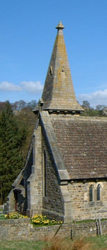
Blubberhouses is just a scattered settlement where the busy A59 Harrogate – Skipton road crosses the Washburn Valley. There was once a mill by the river and lead was mined on the surrounding moors. Today its most prominent feature is the little church on the hill overlooking the traffic heading to and from the Dales.
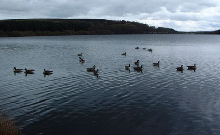
Thruscross – the most northerly of the four reservoirs occupying the Washburn valley. Yorkshire Water has created paths around these reservoirs (details from Yorkshire Water website) that can be linked to other rights of way to create varied walks by the water, through woods and over moors.
Arnold Underwood & LWC (April 2004)
|