
|
NORTH YORK MOORS 16.5km (10ỳ miles)
Blakey Topping & The Bridestones
Farmland, forest and moorland taking in the conical hill of Blakey Topping, before heading to Dalby Forest at Staindale. The return is via the weathered rock outcrops of the Low Bridestones
A good walk for spring before the bracken takes over!
Fact File
|
Distance
|
16.5km (10ỳmiles), but can be shortened.
|
|
Terrain
|
Forest, moorland and field paths & bridleways
|
|
Time
|
4Ẅ hours
|
|
Stiles
|
4
|
|
Grading
|
**** Quite strenuous
|
|
Suitable for
|
Keen walkers
|
|
Start/Parking
|
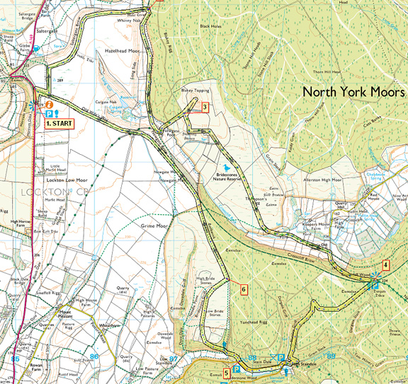
Hole of Horcum (A169 north of Pickering) Grid Ref: SE 853 938 |
|
Nearest Town
|
Pickering
|
|
Refreshments
|
None (Possibly ice-cream vans at Staindale Lake and Hole of Horcum car parks)
|
|
Toilets |
Near Staindale Lake
|
|
Public Transport
|
Coastliner 842 to Whitby passes the Hole of Horcum
|
|
Map
|
OS Explorer OL27 North York Moors (East)
|

Route created using TrackLogs Digital Mapping
Image reproduced with kind permission of Ordnance Survey and Ordnance Survey of Northern Ireland.

- (Start) Walk due north from the car park along the verge of the A169 for a short distance, turning right along a lane (Old Wifes way) to a gate. Follow the sign-posted path left down the side of a plantation to another stile. Do not cross but go right through gat into field. Now an easy stroll along Saltergate Brow with just sheep for company. Down to the left, the famous Saltergate Inn is undergoing conversion and extension to provide holiday apartments. Ahead the pyramid of Fylingdales early-warning station. The ridge swings round to the east and the path slips down its northern flank bringing you to one of the Moors famous crosses Malo Cross.
- (2.5km/1Ẅmiles) From here a narrow path picks its way down the valley between the Rigg on your right and the Forest on the left. Rising above the trees is Blakey Topping. The path cuts across the last field up to the lane leading to the farm at Newgate Foot. Walk down to the farm and bear left following the track down and then up alongside forest to a gate at the foot of Blakey Topping. Although you must return to this point, this hill just has to be climbed. You could perhaps leave some of your gear here and travel light up the hill and back. So go through the gate and up alongside the wall, crossing a stile to continue up a well-made path up through bilberries and bracken to the summit at 270m. Although from a distance the hill appears conical, it is elongated. There is a 360 panorama over the forests and moors. Having taken in the views retrace you steps to the gate.
- (4.8km/3miles) From the gate walk along the top side of the field for about 200m and turn left through another gate. Note hereabouts several large standing stones, thought to be the remains of ancient stone circle. Head east along a track passing some earthworks after which the track swings right down to a gate. The track now heads straight across an expanse of low-lying moor with forest-clad ridges to the south and north. After 1km you leave the moor and enter an oasis of pasture with lamas and some delightful isolated cottages. Negotiate a ford and continue along the narrow lane to a road junction. Turn right here and follow the road up through a gate onto Crosscliff Brow.
- (8.4km/ 5ỳmiles) Here tracks and paths radiate into the forest. The first path on your right as you approach up the hill) is signed Saltergate 4miles. This will take you unerringly (but boringly!) back to the Hole of Horcum. For a more interesting route taken the second track on the right. Go past the barrier and head straight into the forest. Keep to the main track as, in about 400m, swings right and, in a further 200m, right again. In another 100m another track joins from the left. Double-back left to follow this forest track for about 400m. Just after a left-hand bend look out for a narrow path on the right descending into Nattley Griff. This path brings you quickly down to the cottages at High Staindale. Drop down and bear right passing below the cottages to join the Dalby Forest Drive by Staindale Lake. Cut through the car park to join a riverside path which eliminates some road walking. At the western end of the lake you must join the road for the short distance to another car park and public toilets.
- (11.2km/ 7miles)Walk through the car park on the right to pick up footpath heading for the Bridestones. Ignore path left and enter the woodland. At the next fork, keep left to face a steady climb up through the trees to reach open moorland. The path turns right and heads for the string of rock features that comprise the Low Bridestones. Across to the left can be seen the High Bridestones on the parallel ridge. After passing all of the Low Bridestones, take the right fork and head across the moor to join the direct route from Staindale and turn left.
- (12.8km/8miles)The track heads along the edge of the forest to a gate and there joins the direct path from Crosscliff Wood. This track, Old Wifes Way, now takes you along the top of Newgate Brow with an excellent view of Blakey Topping (seen elongated from this direction). Its easy albeit not exciting walking for final km back to the gate. Turn left back to the car park.(16.5km/10ỳmiles)
Along the Way

Malo Cross
A boundary stone which, like Mauley Cross, is named after the de Mauley family who lived at Mulgrave Castle, near Sandsend.
Carved on its north-east head are the initials K with R E beneath - Sir Richard Egerton (Knight).
Blakey Topping
It is said that the giant Wade, following an argument with his wife, scooped up a handful of earth (creating the Hole of Horcum) and threw it at her. He missed her and it landed 1mile to the east forming Blakey Topping.
The legendary Saltergate Inn
Alas the fire has gone out, and this famous inn is being converted and extended to provide holiday apartments! However plans do show provision for a licensed area does this mean that one day the fire will burn again?
Bridestones a name given to various rock outcrops around the country. These sandstone outcrops have been weathered by wind and rain over thousands of years.
Arnold Underwood (July 2008)
|
