|
LINCOLNSHIRE - Donington-on-Bain
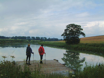
The Lincolnshire Wolds and River Bain
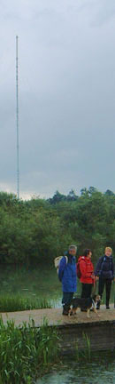
Lincolnshire Wolds - an area overlooked by æserious walkersÆ. The landscape may not be dramatic, but the rolling hills to provide open views across this intensively farmed countryside and there are numerous delightful villages tucked away among the folds of the landscape. Belmont TV transmitter above Donington-on-Bain will be your constant point of reference throughout this walk.
Fact File
|
Distance
|
16km/10 miles
|
|
Time
|
4Į hours
|
|
Map
|
OS Explorer 282, Lincolnshire Wolds North
|
|
Start/Parking
|
Donington-on-Bain (grid. ref: TF 236 829) ¢ with landlordÆs permission you may be able to use the pub car park. Alternative parking & start on unfenced road near Biscathorpe Church.
|
|
Terrain
|
Field paths, bridleways, and minor roads across undulating farmland
|
Grade
|
** (moderate)
|
|
nearest Town
|
Louth
|
|
Refreshments
|
Pub - The Black Horse - in Donington-on-Bain
|
|
Toilets |
none
|
|
Public Transport
|
Lincs Road Car service 158 (1 journey, Wed only). CallConnect Plus 51L from Louth - Demand Responsive service (Mon - Sat)
|
|
Suitable for
|
all
|
|
Stiles
|
8
|
- (Start) 1. Set off due north along the road out of the village. In about 800m (Į mile), at a bend, you will see the restored Mill Cottage ahead, on the River Bain. Take the right fork at the road junction then immediately left into fields to follow the Viking Way. This follows the valley of the River Bain due north, past a lake and reed beds. In due course cross a footbridge left over the river and head for the church at Biscathorpe and on to an unfenced road - (Alternative start/parking). Turn right along this road, which fords two tributaries of the river ¢ there are footbridges for walkers ¢ through a gate and up hill.
- (3.2km/2 miles) At a bend at the brow of the hill turn right along a broad bridleway that you will now follow for about 4km (2Į miles) along this ridge of the Lincolnshire Wolds. DonÆt miss a right turn in about 400m (╝ mile) otherwise you will end up at Grange Farm. After a further 1.6km (1 mile) you cross a minor road and 800m (Į mile) after that a footpath right provides a short cut back down to Donington.
- (6.8km/4Į miles) At the next road turn left up the hill towards a radio mast ¢ note the collection of disused radar dishes, no doubt redundant following the closure of RAF Binbrook a few years ago. Opposite the radio masts fork right along a farm track, and in a further 400m (╝ mile) turn left (the track on to Cold Harbour Farm is not a right-of-way). This brings you to another road where you turn right and walk to the next crossroads. There turn right again to follow this road, past the entrance to Cold Harbour Farm, to a road junction above Stenigot.
- (9.8km/ 6╝ miles) Take the left fork and you soon arrive at open area of hillside, now a Nature Reserve. Here you can leave the tarmac and follow a path downhill through this Reserve. This is an ideal area for a picnic lunch with views southwest over the valley. The path brings you steeply down through old quarry workings to the road down Red Hill. Opposite the road junction at the bottom of the hill a footpath continues through Manor Farm and along field edges. Ignore a footpath crossing at right angles and you will reach and enter an overgrown cemetery.
- (11.8km/7Į miles) Leave the cemetery and turn right along a track on the Viking Way once more. Follow this track for about 400m (╝ mile) as it skirts Colley Hill to arrive at a gate into open grazing land. The footpath goes right, through thistles, to follow the edge of the field around a small hill. As you approach an area of scrub and marsh, swing left round the hillside until the path descends to cross a boggy area and enters a belt of woodland. Beyond the wood you soon reach anther minor road. Turn right here and follow the road round through Fox Covert.
- (13.8km/ 8Š miles) Just beyond the trees, turn left to continue on the Viking Way along a permissive path, through farmland to eventually turn right along a track, which turns to cross the route of a long-gone railway line. The footpath now continues along the edge of fields back into Donington-on-Bain. (16km/10 miles)
An interesting extension of about 2.4km (1Įmiles) would be to turn left on entering the village and walk past the sewage works, across the River Bain, and up to the lakes at Benniworth Haven. Return via the bridleway to Benniworth House Farm, then down a footpath, across the river back into Donington.
Along the Way
Biscathorpe ¢ the parkland setting here was once the site of a village in medieval days, and the earthworks can be made out on the hillside opposite the church. All that remains today are the church, one or two houses, and Biscathorpe House further up the hillside behind the trees.
Arnold Underwood & LWC (June 2004)
|