|
EAST YORKSHIRE - Beverley (8½miles)
As featured in Country Walking Magazine September 2003
Beverley By-ways
This is any easy ramble, along quiet lanes and tracks to the south of Beverley. A rural backwater sandwiched between the expanding market town of Beverley and the sprawling estates of north Hull. The walk starts on Beverley Westwood, where commoners still have rights to graze their cattle from April to October.
Fact File
|
Distance
|
13km/8½ miles
|
|
Time
|
4 hours
|
|
Map
|
OS Explorer 293 (Kingston-upon-Hull and Beverley)
|
|
Start/Parking
|
Beverley Westwood (grid ref: TA 028 395). There is hard standing for a few cars by the Westwood gates - otherwise park carefully on the verge
|
|
Terrain
|
Field paths and bridleways, which can be muddy in places.
|
Grade
|
** Easy
|
|
nearest Town
|
Beverley
|
|
Refreshments
|
plenty of pubs and cafés in Beverley. The nearest pub to the Westwood is the Woolpack, just down the road from the start/finish point of the walk.
|
|
Toilets |
None
|
|
Public Transport
|
plenty of buses to Beverley from surrounding area. Service 180 operates via the Westwood to Walkington
|
|
Suitable for
|
for all, but care needed in crossing the busy A164 road
|
|
Stiles
|
3
|
- (Start) Set off along the edge of the Westwood past the backs of houses to the gates at the top of Cartwright Lane. Turn left, cross the road, and walk down towards the town. At a mini-roundabout cross the busy road and continue towards Beverley Minster. By some flats turn right into Kitchen Lane. Follow this old lane past allotments continuing forward (not left) where it becomes confined between old hedgerows, eventually emerging at a new link road (currently to nowhere). Cross over and continue with a new school on your left and modern housing on the right. At steps your path joins a tarmac path along the edge of the estate. Where this modern path twists and turns, keep straight on by the hedge on the grass, following a way-marked ‘running track’. This track passes through a thicket to emerge again on a tarmac path.
- (2.5km, 1½miles) Bear left, cross a footbridge over a dyke and follow the field side path through the flat agricultural landscape known as Beverley Parks. Cross another footbridge, head across fields to come to a lane (Shepherd Lane). Ahead can be seen the tower blocks of North Hull, and looking back, by way of contrast, can be seen Beverley Minster. Follow the lane to a junction.
- (4.8km, 3 miles) Turn right along a track, which takes you past a farm, round a bend and over a bridge crossing the Beverley By-pass. Just over the bridge turn sharp right at bridleway sign and follow a muddy track along the field side, adjacent to the main road. Eventually the hedgerow swings away from the by-pass taking your path towards a belt of woodland. Here you join a tarmac farm road, which you follow past a cottage down to the main A164 Humber Bridge link road.
- (5.8km, 3¾miles) You are now faced with the most hazardous part of the walk – crossing this very busy road to the bus stop opposite. From there, a footpath leads into the hamlet of Bentley. Walk through Bentley, past the tiny church, to join the Walkington road. You must now follow this road for about 1km. Once round a sharp right-hand bend there is a reasonable amount of verge on the right by which to avoid the traffic.
- (8.4km, 5½ miles) Just past Bentley Park House, a large red brick building, a ‘Beverley 20’ footpath sign points the way along a broad green lane which swings right into Bentley Moor Wood. Through the wood turn left, over a stile (Beverley 20 sign) and head north along field sides. Maintain direction ignoring a path to the right, until the path swings left then right becoming confined by hedgerows. Go through a gate to reach the Walkington Road (B1230). Turn right along the footpath crossing the bridge over the Beverley by-pass.
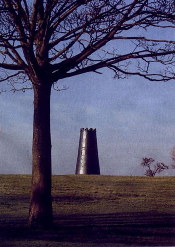
- (9.5km, 6½ miles) Over the bridge, immediately cross the road and head down a track alongside the by-pass. This track descends and after about 400m, just past a belt of woodland, a gate on the right opens onto a path. Take this path towards Beverley Westwood – Black Mill can be seen straight ahead. The path, sticky in places follows the bottom edge of fields – its confining fence having fallen into disrepair – until it bears left to a gate onto the Westwood. Keeping a good lookout for golfers, walk along a shallow valley in this undulating landscape. Climb a rise towards bushes passing right of a green, to cross a ‘bridge’ over the racehorse gallops and aim for Black Mill. Bear left at the mill and the trace of an old track can be followed towards Beverley. Negotiate the gallops again and continue down to the information board and car-parking area.(13km/8½miles)
Along the Way
Time permitting you could explore more of the Westwood or head down Westwood Road into Beverley. Black Mill is the more obvious of two former windmills on the Westwood - the other is incorporated into the golf course clubhouse. These mills were once used for grinding corn from farms in the surrounding area.
Beverley is the county town of the East Riding of Yorkshire and has much to interest the visitor. The main attraction is the Minster, but there is also the Priory, North Bar – the one remaining gateway into the old town, St Mary’s Church, and the many pubs!
Arnold Underwood (Dec 2004)
|

