|
EAST YORKSHIRE COAST - Barmston - (16km, 10miles)
'Crumbling Coastline'
When the Vikings landed at Barmston they had twice as far to walk from the beach to the village as we have today. Today’s visitors to the sandy beaches arrive by car from towns across East and West Yorkshire.
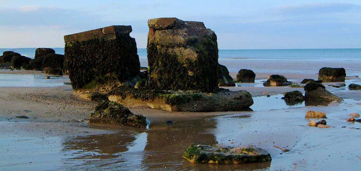
The low clay cliffs of the Holderness coastline are being eroded rapidly and the piecemeal efforts at sea defence to protect towns and villages along the coast may have resulted in greater erosion elsewhere. On this walk, a short section of cliff-top path just north of Barmston has disappeared and you may have to walk along the beach - so check the tides before embarking on this stretch!
Fact File
|
Distance
|
16.0km (10 miles)
|
|
Terrain
|
Flat - A mixture of field paths and farm tracks, which can be muddy, minor roads, and sections of beach and low cliff-top.
|
|
Time
|
4˝ hours
|
|
Stiles
|
6
|
|
Grading
|
** moderate
|
|
Suitable for
|
all
|
|
Start/Parking
|
Barmston cliff top or at roadside in the village, but remember roads are busy at holiday times (Grid Ref: TA 171593)
|
|
nearest Town
|
Bridlington
|
|
Refreshments
|
Shop and the Black Bull Inn at Barmston; seaside cafés in season at Barmston and shops, fish & chips, and the Board Inn at Skipsea
|
|
Toilets |
none
|
|
Public Transport
|
Infrequent services 270/130 from Bridlington to Driffield or Hornsea. More frequent at holiday times.
|
|
Map
|
OS Explorer 295 (Bridlington, Driffield & Hornsea)
|
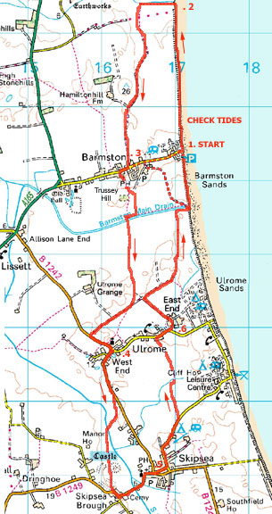
Image reproduced with kind permission of Ordnance Survey and Ordnance Survey of Northern Ireland.

- (Start – if tides favourable) At the east end of Barmston village the road ends abruptly, just past the entrance to a caravan park, at a "road closed" barrier on the cliff top. The footpath northwards from here should be along the cliff top, but this has been eroded back to the caravan park boundary fence, so if the tide is in your favour descend the slipway to the beach. Walk north along the beach with the long sweep of Bridlington Bay extending round to the cliffs of Flamborough Head with its lighthouse. The cliff, which was quite high at Barmston soon drops to just above beach level and you may find walking easier on its firmer ground. Continue north for about a mile (1.6 km) to where another drainage channel enters the sea at Fraisthorpe Sands.
- (2.4km, 1˝miles) North of here, the wide sweep of Bridlington Bay continues round to Flamborough Headland. Turn to walk inland alongside the southern side of the drainage dyke, called The Earl's Dike on some maps. At a waymark post turn left to head south. Go through a gate and join a farm track. This track skirts Hamilton Hill with its trig point, and leads back to the centre of Barmston village.
- (4.8km, 3miles - Alternative Start) At the road go right to pass or into the Black Bull pub. A few yards further, by a white cottage, turn left at a footpath sign to pass barns where fishing nets and lobster pots are repaired. Enter a field at a stile by a gate and walk straight across into a dense copse of trees and bushes. The path bears left and emerges from the woodland. Turn right at a broken gate and ahead is a strange sight - a conical mound, known as Trussey Hill, topped by a circle of skeletal tree trunks, looking like a timber version of Stonehenge. Maps show the right of way crossing the mound, but the path has been diverted left around the field side - follow the waymarks. Turn right alongside Barmston Drain then left to cross it at a footbridge. This drainage channel is surprisingly large - steep-sided, deep and wide. Most of the drainage dykes of northern Holderness feed into this drain. From the end of the footbridge continue straight on along the fieldside towards Ulrome, whose church is visible in the distance. It's about a mile (1.6 km) along the field side and it can be rough and muddy underfoot. Eventually you come to and turn right along a farm road, known as North Turnpike. A footpath forks left across the fields towards Ulrome church, but this may well be difficult to follow, so continue straight on to the junction with the B1242 road. Turn left to head into Ulrome West End by the church and the duckpond.
- (7.6km, 4ľmiles) Turn south along the B1242 towards Skipsea. In about ˝ mile (0.8km) at a footpath sign on the right leave the road and follow a path across fields to reach the prominent mound of Skipsea Castle. From the earthworks, walk up the tractor track to a stile by a gate. Walk along the road, which twists and turns through Skipsea Brough, past the church into Skipsea village.
- (10.4km, 6˝miles) Go straight on at the road junction past the war memorial and take the narrow lane on the left passing the Board Inn and heading towards Skipsea Sands. About ˝ mile (0.8km) out of Skipsea, a footpath sign by a stile indicates the way across fields towards Ulrome. After two fields of crops, which can be heavy going, the path enters an area of newly planted woodland – Rickarby woods, which can be explored by a network of paths. On reaching the road in Ulrome there, turn right and walk through the village towards the sea.
- (12.8km, 8miles) By a large Seaside Caravan Park name-board, bear left down a lane called North Road into East End. Follow this track round to the left, ignoring a footpath sign by the hedge on the right. Follow the track as far as a T-junction with North Turnpike and there turn right and head once again for the coast. At the end of the track continue straight on past a sign forbidding vehicles. Keep to the field side as it swings north, eventually coming to a drainage channel. Follow this channel towards the sea and join a rough track coming from the right. Follow this track along the top of the low cliffs. It dips to cross the Barmston Main Drain and continues along the cliff above Barmston Sands. Bear left to pass inland of two precariously situated buildings to join the road opposite the entrance to the caravan park on Barmston cliffs. (16km, 10miles)
Along the Way
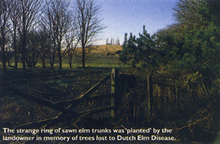
The mound at Barmston is ancient, being a Viking burial ground, but the trees on it are not. The circle of sawn elm trunks was "planted" by the landowner in recent years in memory of trees killed by the Dutch elm disease.
Skipsea Castle was built by Drogo de Beverer, who was made Lord of Holderness immediately after the Norman Conquest. Today the mounds of his Motte and Bailey castle are still prominent in the fields west of All Saints Church, Skipsea.
More recent ruins of fortifications are the wartime "pill-boxes" along the cliff top, although many have been swallowed up by the encroaching waves.
Large caravan parks have grown up along the coastline bringing a large influx of holiday-makers in the summer months - their number greatly exceeding the resident population. However the locals have benefited as they have use of the leisure facilities provided for the holidaymakers.
Arnold Underwood (Jan 2004,July 2006)
|