|
EAST YORKSHIRE WOLDS - Bainton - 15km (9Ẅmiles) or 10km (6Ẅmiles)
'Wolds & Woods'
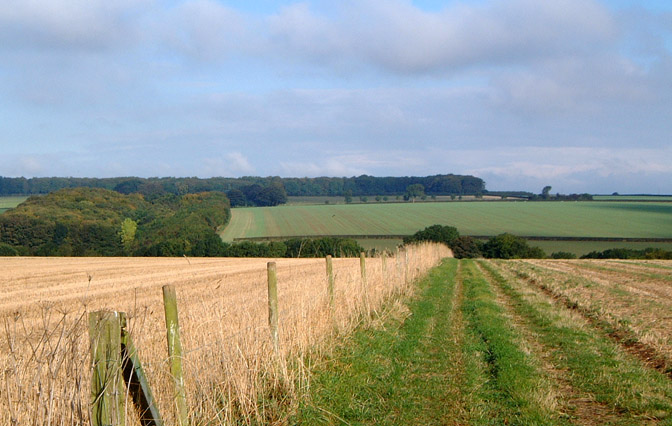
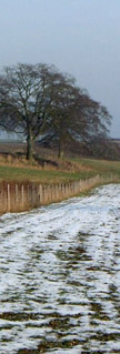
Winter is a good time to explore the rolling landscape of the Yorkshire Wolds with its wide open views. This is an ideal walk for this time of year as the going is generally firm underfoot, other than for a short stretch near Bainton.
Fact File
|
Distance
|
15km (9Ẅmiles) or 10km (6Ẅmiles)
|
|
Terrain
|
Field & woodland paths, tracks & minor roads
|
|
Time
|
4 (3) hours
|
|
Stiles
|
8
|
|
Grading
|
** easy
|
|
Suitable for
|
all
|
|
Start/Parking
|
Lay-by off A614 just north of Bainton(Grid Ref: SE ) |
|
nearest Town
|
Driffield
|
|
Refreshments
|
Wolds Village Tea-rooms & Restaurant near Bainton roundabout, Star Inn at North Dalton.
|
|
Toilets |
none
|
|
Public Transport
|
Buses 142 and 743 from Driffield serve North Dalton and Bainton Church (Mon-Sat) and 744 (York Driffield - Bridlington, daily) serves North Dalton and Bainton Roundabout.
|
|
Map
|
OS Explorer 294
|
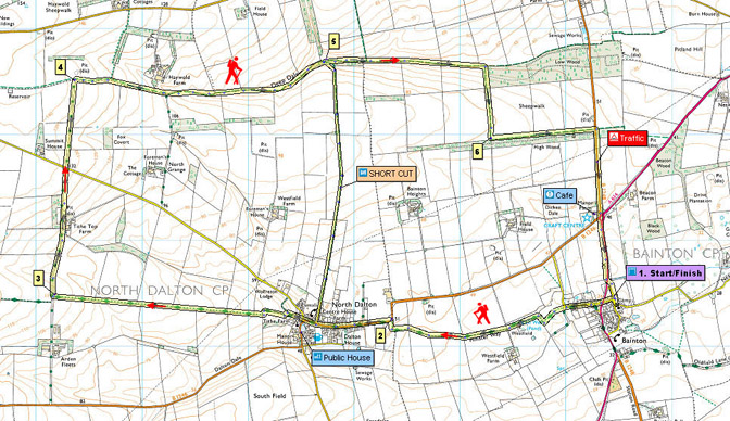
Route created using TrackLogs Digital Mapping
Image reproduced with kind permission of Ordnance Survey and Ordnance Survey of Northern Ireland.

- (Start) Walk towards the church and turn right down the lane opposite. Cross the busy A614 with care and take the road opposite. Turn left past cottages and at the end, where the road turns right, go through a gate to the left into a field (way-marked Minster Way). Continue forward across earthworks to a kissing gate into the next field. Turn right to arrive at a gate, where it can be muddy. Cross a decrepit stile by the gate and go left alongside the hedge towards a small wood. Walk round the edge of the wood note Ell Well, a pond, inside the wood and come to gate onto a farm road. Cross the farm road and walk on along a wide track (still on the Minster Way). Cross a stile and turn right to a road. .
- (3.2km, 2miles) Turn left along the road (B1246) into North Dalton. The Star Inn is at the west end of the village, round the corner by the village pond. The church stands on small hill opposite. (For shorter route, you must back-track and take a lane heading north by the telephone box. This track passes the village cricket pitch and after passing through a gate climbs gradually onto the Wolds, with good views all round. The track now drops down to reach woodland. Go through a small gate and follow a narrow path which bears left down through the trees into Deepdale at point 5.) In North Dalton Take a lane heading west past Tithe Farm. A footpath sign now indicates the way, left, along a sunken lane. At the end of this lane cross a stile and go left round two sides of a small field. With a hedge now on your left, go through a gate, and head west alongside the hedge for about 2km (1ỳ miles) to meet a concrete farm road.
- (6km, 3ẅ miles) Here you leave the Minster Way and turn right and follow this farm road due north for about 1km (ẅ mile) to a road. Cross straight over and continue north on what is now a green lane between hedgerows. At the top you meet another green lane, the Hawold or Haywold bridle road, at right angles.
- (7km, 4Ẅmiles) Turn right to follow this ancient route due east for about 3km (2ẅ miles). Cross a farm road from Haywold Farm which is in a sheltered valley to the left. The route then gradually descends into this valley amid rolling farmland. In area shown as Deepdale on the OS map you come alongside a belt of woodland on the right. It is here the shorter route joins from North Dalton.
- (9.5km, 6miles)Continue east on the ancient Hawold track along the valley floor to the corner of Low Wood. Turn right here uphill alongside the wood and on towards High Wood, Do not enter this wood - the track in High Wood is private and is not a right-of-way
- (12km, 7Ẅmiles) Turn left and walk along the edge of this wood to reach the B1248 road. Turn right along the road. You must now walk along the verge of the B1248 for about 0.8km (Ẅ mile) back towards Bainton. Take care as this is a straight, fast stretch of road. Just before Bainton roundabout are the Wolds Village Tearoom and craft centre, which is worth a visit. From the tearoom, walk to the roundabout and cross the B1246 to join the footpath, which runs from the bus-stop to Bainton village, alongside the A614. Note the ruined tower of and old windmill on the right before crossing the main road to reach the lay-by. (10km/7miles)
Along the Way
The Minster Way is a 40mile route linking the Minster Churches of Beverley and York.
The architectural style of St Andrews church at Bainton dates from the 14th century the outside wall is decorated with the faces of some strange animals!
There were once several windmills in the area the one in ruins seen on the edge of the village was built in 1818.
Arnold Underwood (Oct 2004)
|