
|
COMMON & CANAL
Allerthorpe Common and the Pocklington Canal (9Ẅ miles)
A walk for winter with no hills. Starting out through the woods and heathland of Allerthorpe Common followed by a pleasant section of the Pocklington Canal as far as Melbourne village
Fact File
|
Distance
|
15.2km/9Ẅmiles
|
|
Terrain
|
Minor roads, bridleways and canal bank
|
|
Time
|
4 hours
|
|
Stiles
|
5
|
|
Grading
|
** Easy
|
|
Suitable for
|
all but care along country roads
|
|
Start/Parking
|
Allerthorpe Common. Grid Ref. SE 752473 |
|
Nearest Town
|
Pocklington
|
|
Refreshments
|
Allerthorpe Lakeside Park tearoom. Pubs in Allerthorpe and Melbourne, and numerous pubs and cafes in Pocklington
|
|
Toilets |
Allerthorpe Lakeside Park (for patrons only)
|
|
Public Transport
|
East Yorkshire bus X46 Hull - York serves Pocklington
|
|
Map
|
OS Explorer Market Weighton & Southern Wolds
|
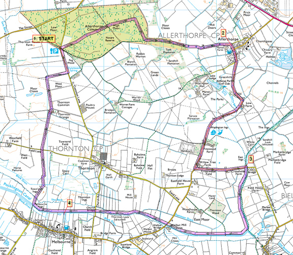

Route created using TrackLogs Digital Mapping
Image reproduced with kind permission of Ordnance Survey and Ordnance Survey of Northern Ireland.

- (Start) From the car park cross the road and go through the gate. Take the left fork (not the bridleway) and follow the broad ride across the common. The common is a mix of sandy heath, dotted with silver birch and gorse, and dense blocks of coniferous woodland. Head straight on until you come to fence. Here turn right and walk down the edge of the wood eventually reaching open farmland. Continue along the clear path and swing right into Allerthorpe village to reach a T-junction by the Plough Inn.
- (3.1km/2 miles) Turn right and walk along the pavement out of the village. You now have about 1Ẅ miles of roadside walking. Although only a country road it is quite busy. There are a couple of stretches of wide verge to give relief from the tarmac, one being by the entrance to Allerthorpe Park Lake. The café here, overlooking the lake, might tempt you for morning coffee or afternoon tea! Continue along the road past the entrance to an electricity sub-station and then turn left along a narrow lane towards Bielby. This brings you to humped-back bridge over the Pocklington Canal by a restored lock.
- (6.3km/4Ẅmiles) Cross the stile on the right before the bridge and head west along the right bank. You can walk on either side of the canal, but keeping to this side avoids a deviation into Bielby. This section is rather overgrown, which is odd because the locks appear to have been restored. You pass a swing bridge, which hasnt swung for many years and in another mile reach another lock at Walbut Bridge. There are a few seats here making it a pleasant place to stop on a nice day. Follow the towpath under the road bridge to continue towards Melbourne. Here there is a canal basin, which should be holding a few boats, as the canal is navigable this far, from the River Derwent. Cross the swing bridge to reach the canal basin and the path into Melbourne village (for the pub).
- (11.2km/7miles) From the swing bridge, continue along the canal from Melbourne as far as a footbridge. Turn right away from the canal to follow this path across squelchy ground to a footbridge over a drain. Continue along the next field side (also squelchy underfoot) to a gate in the corner. Go through and left to continue on a tractor track along field sides to Thornton Grange Farm. After passing the farm, maintain direction along field side with Allerthorpe Woods directly ahead. At the end of the field turn right (by a fallen waymark post) and continue to the Thornton road. Turn left along the road back to the car park at the edge of the wood. (15.2km/9Ẅmiles)
Along the Way
The Pocklington Canal was built in 1818 by George Leather Junior, linking the market town of Pocklington on the edge of the Wolds with the River Derwent and thence to the industrial towns of West Yorkshire. In 1847 it was sold to the York & N Midland Railway Co after which trade declined. The last commercial barge use was in 1932. The Pocklington Canal Amenity Society was formed in 1969 with the intention of restoring the canal. With the assistance of British Waterways and Humberside County Council they have so far completed half the task as far as Melbourne
The canal is now one of the most important waterways for wildlife in the whole of the UK. It is bordered by grassland, which offers rich pickings for the Barn Owl, which is thriving in this ideal environment. Thirteen species of dragonflies and damselflies can be found along the ten-mile stretch of the canal including the Emperor dragonfly, Britain's largest.
Allerthorpe Common Nature Reserve is a small but superb example of lowland heath in the Vale of York, supporting an impressive range of heathland wildlife. It is designated as a Site of Special Scientific Interest.
The reserve is a particularly good place to see adders and lizards, it supports a rich variety of water beetle and dragonfly species, and it is one of the last places in Yorkshire where the Marsh St. John's-Wort thrives
Arnold Underwood with LWC (Feb 2008)
|
