
|
North Lincolnshire - Alkborough 15.0km (9Ẅmiles)
'An amazing walk'
Alkborough is a picturesque village in North Lincolnshire situated overlooking Alkborough Flats and Trent Falls - where the Rivers Trent and Ouse merge to for the Humber.The village is famous for its 'turf maze' known as Julian's Bower which is situated near the viewpoint over the river. The walk crosses farmland to Winteringham, then follows the flood bank of the Humber back round to Whitton and up to Alkborough
Fact File
|
Distance
|
15.0km (9Ẅmiles)
|
|
Terrain
|
Field paths and tracks, river bank. Just one short climb at Whitton
|
|
Time
|
4 hours
|
|
Stiles
|
10
|
|
Grading
|
** Easy
|
|
Suitable for
|
all
|
|
Start/Parking
|
Alkborough; park to avoid causing congestion or at Paddocks tea-room (please ask first) |
|
Nearest Town
|
Winterton
|
|
Refreshments
|
Paddocks Tearoom in Alkborough (check opening times - e-mail: College Farm - Paddocks Tearoom), Bay Horse Inn at Winteringham
|
|
Toilets |
None
|
|
Public Transport
|
Stagecoach Service 60 from Scunthorpe (not Sundays) - not convenient for walkers; Frequent Humber FastCat 350 from/to Hull/Scunthorpe serves Winteringham (daily)
|
|
Map
|
OS Explorer 281 Ancholme Valley (Scunthorpe & Barton)
|
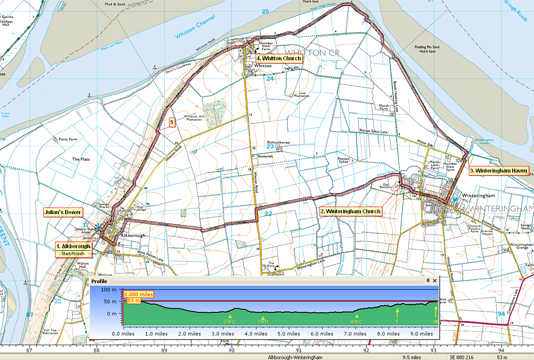

Route created using TrackLogs Digital Mapping
Image reproduced with kind permission of Ordnance Survey and Ordnance Survey of Northern Ireland.

- (Start) Walk out of Alkborough in the direction of West Halton. Were the road bears right a footpath sign on the left indicates a path along the back of houses through some well-maintained gardens. Pass a run containing Amys chickens and enter a paddock which may contain sheep. The path angles right and comes to a lane which you cross and continue through more paddocks
- (1.5km /1mile) Turn right here onto a clear path across arable land heading directly towards Winteringham, three miles away. At the Whitton/West Halton road turn left, and then, after about 50yards, turn right to maintain easterly direction. In a further half-mile the path does a right-left zigzag across a footbridge spanning a dyke. Now walking with the deep dyke, Haven Drain, on your left Winteringham church on its small hill can be seen directly ahead. Continue along the track by the drain, ignoring the right turn of the path, shown on the OS map. At a footpath sign turn right which brings you to Winteringham Church.
- (4.5km /2ẅ miles) Walk up the lane by the church and turn left into the village. Follow the road through the village, which has many interesting old buildings, until you come to a crossroads by the Bay Horse Inn. Turn left here and taking heed of the notice on the pub wall walk downhill past old cottages towards the River Humber and Winteringham Haven. This rather exotic name applies to what these days, is a muddy creek, home to the Winteringham Sailing Club. Many centuries ago this was a major crossing point of the Humber between Roman settlements on the Ermine Way. Turn left to cross Haven Drain and, by an information board, go through a footpath gate to access the Humber flood bank.
- (6.6km /4ỳ miles) The path now follows the flood bank for 3miles to the village of Whitton. Navigation is straight forward just keep the river (or mud if the tide is out) on your right. There seems no sign of the path shown on the OS map cutting across the fields, and the obvious route is to follow the curve of the river bank round Whitton Ness. If the tide is low, the mud flats will be attracting flocks of waders, ducks, and geese. As you swing round towards Whitton, the flood bank becomes further from the river, being separated by a floodplain of grassland, broken up by pools, drains and ditches a favourite grazing area for geese
- (10km/6Ẅmiles) At Whitton your walk along the flood bank ends at a gate, where there is another information board. Turn left into the village and walk uphill yes another hill past the interesting church. At the top of the hill go straight across the road to a footpath gate. From here your route continues along the hillside with panoramic views across the Humber to East Yorkshire and beyond. The steep hillside is used by a local motor-cycle scrambling club, so you may find the otherwise peaceful surroundings disturbed somewhat! The cattle that share the same hillside seem unconcerned though. Keep to the higher path where signs show a choice and continue along the top. The path now enters a wooded area and switches to walking along a field edge with your views across the river blocked by the trees.
- (12.4km/7ẅmiles) After about 800m you emerge onto the open hillside again overlooking an area of flooded land known as Alkborough Flats. This low-lying ground was originally drained for agriculture, but in recent years the river bank has been breached to allow it flood again. This provides an ideal habitat for wildlife as well as reducing the risk of flooding elsewhere. Continuing along the top of the ridge back into trees where surprisingly you have to go down some steep steps to cross a track then back up the other side and over a footbridge. As you approach Alkborough the path becomes enclosed by a wire fence as you continue under the shelter of trees to emerge onto an access road. Cross and follow the path signed Prospect Lane and continue below houses then up into the village near the church. Cut through to the church and take a few minutes to look in the porch at the maze set into the floor. Leave the church to continue along Back Street turning right at the sign to visit Julians Bower (the turf maze) and the view point. From here you look out over the Flats to Trent Falls where the River Trent merges with the Ouse to form the Humber. The tearoom is just round the corner.
Along the Way
Alkborough
Alkborough turf maze, also known as Julians Bower, sits high on the Trent Ridge. Thought to be cut by Monks in the 12th Century, the site offers panoramic views across the confluence of the rivers Trent, Ouse and Humber.
Although referred to as a maze, being unicursal and having only one way in and one path through, it is more accurately a labyrinth.
The pattern of the maze is recorded in a 19th century stained glass window and on the floor of the porch of the nearby Church of Saint John the Baptist, and also on the gravestone of James Goulton Constable in Alkborough cemetery.

Alkborough Flats is an area of low-lying arable farmland of nearly 4 kmĠ situated at the "Confluence of the Rivers" (Trent Falls) where the Rivers Trent and Ouse join to form the Humber estuary. The alluvial plain and is now jointly owned by the UK's Environment Agency and English Nature.
Alkborough Flats was used as a bombing range during World War II. Bombers would take off from RAF Elsham Wold and drop smoke bombs on the target.
Flood defences which were built in the 1950s to protect the area, have been breached to allow water to reclaim the land at high tide and in times of flooding. This has created a new intertidal habitat in the inner part of the Humber estuary with reed beds, lagoons and grazing areas.
Arnold Underwood (Sept 2011)
|
